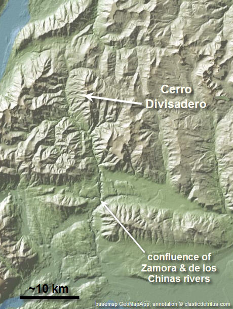
Cerro Divisadero – my PhD field area in Patagonia
A paper for a component of my PhD work is finally in press (woo hoo!). I will put together a post about it once it’s uploaded to Sedimentology’s website.
Before that though, I wanted to describe the general setting and show some photographs of my field area. The paper is about a detailed outcrop study of deep-marine stratigraphy at a mountain called Cerro Divisadero in southern Chile.
First, I will take you through a series of maps zooming in on the area.
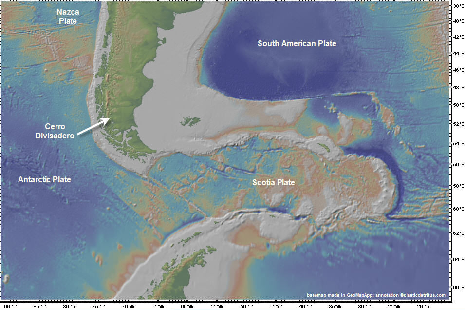
basemap made in GeoMapApp
My worked was focused on sediments deposited in the latest Cretaceous (~75-65 million yrs ago). In the map above, you’ll need to “undo” the Scotia Plate and put the southern tip of South America and the northern tip of the Antarctic Peninsula back together. The timing and details of the development of the Scotia Plate and related tectonic features are, of course, much more complicated than that. But, for the purposes of this post we need not dwell on the post-Cretaceous tectonic evolution.
Below is a paleographic map at around 66 Ma from the Paleomap project website. Look at the southern tip of South America and note that narrow north-south oriented marine basin. This basin is the Magallanes Basin (a retroarc foreland basin); also called the Austral Basin in Argentina.
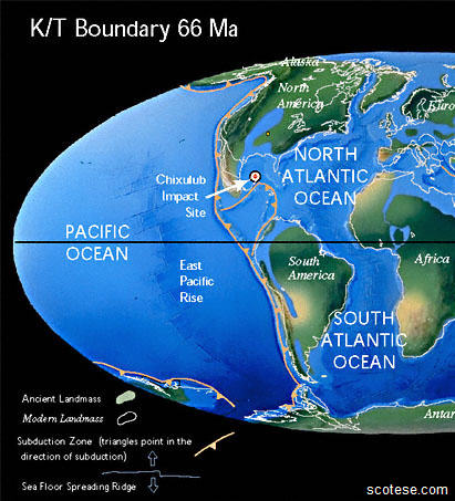
The Magallanes Basin was an elongate marine basin that widened and opened to the south. Eastward subduction and an associated eastward-propagating fold-thrust belt created an orogenic (i.e., mountain) belt. Foreland basins form adjacent to these mountain belts and end up collecting the clastic detritus shed off the mountains (another chapter of my PhD was investigating these larger-scale tectonic evolution with provenance analysis … I’ll post about at some point in the future).
For this post, you need to picture a medium- to large-sized sediment dispersal system filling in that basin from north to south. As the deltas advanced basinward (southward) they fed a linked deep-marine slope system in which turbidity current deposits (i.e., turbidites) were deposited (see this simplified block diagram for a visualization, but note that that example is not a direct analog).
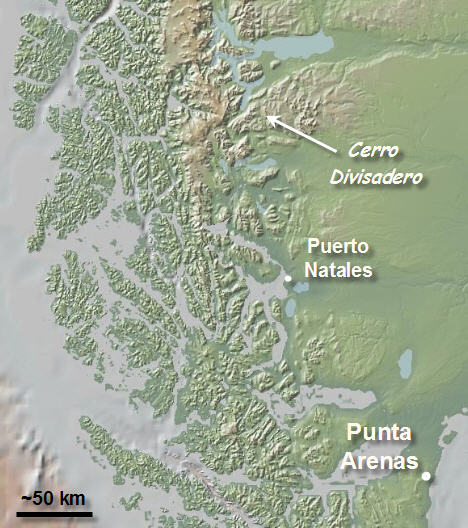
Okay, let’s zoom in a bit more … the map below shows the position of Cerro Divisadero relative to a Chilean town on the Straight of Magellan called Punta Arenas. This is the city most fly to when they visit Chilean Patagonia. For us, the journey from California would typically be something like: San Francisco -> Los Angeles -> Lima -> Santiago -> Puerto Montt -> Punta Arenas and would usually be a 20-hour journey when added up.
basemap made in GeoMapApp
From Punta Arenas, we would drive (~3 hours) to a much smaller town called Puerto Natales, which sits on the shores of the most inland position of the Seno Ultima Esperanza, which connects to the Pacific Ocean. Puerto Natales would be our “base” for 5-7 weeks each year – this is where we would buy food and other supplies (and get a shower) between excursions into different field sites.
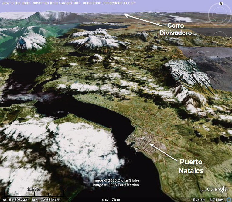
The next map below zooms in showing a perspective view to the north (from GoogleEarth) with Puerto Natales near the bottom of the image. Cerro Divisadero is in the distance to the north. Note the east-dipping strata on the right side of the image. That is part of this Upper Cretaceous outcrop belt that trends north-south (parallel to the Andean orogen).
basemap from GoogleEarth
Before we head north to Cerro Divisadero, below is a photograph of the view from the Puerto Natales waterfront.
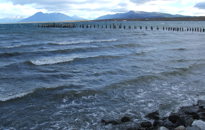
Seno Ultima Esperanza, Puerto Natales, Chile (© 2008 clasticdetritus.com)
Puerto Natales is a bustling little town in the summer … it is the closest town to one of the main attractions of Chilean Patagonia, Parque Nacional Torres del Paine. So, there was always a lot of backpackers/trekkers from around the world milling around town (mostly Europeans, Australians, Chileans from the north, and Americans). Unfortunately, after four field seasons I don’t have any photographs of the town itself … just rocks and scenery nearby. Doh!
From Puerto Natales it is about a 2 1/2 hour drive to the confluence of two rivers, the Rio Zamora and Rio de los Chinas. The map below shows another topographic map zoomed into that confluence and Cerro Divisadero.
basemap made in GeoMapApp
Alright, we’re getting closer but still not there.
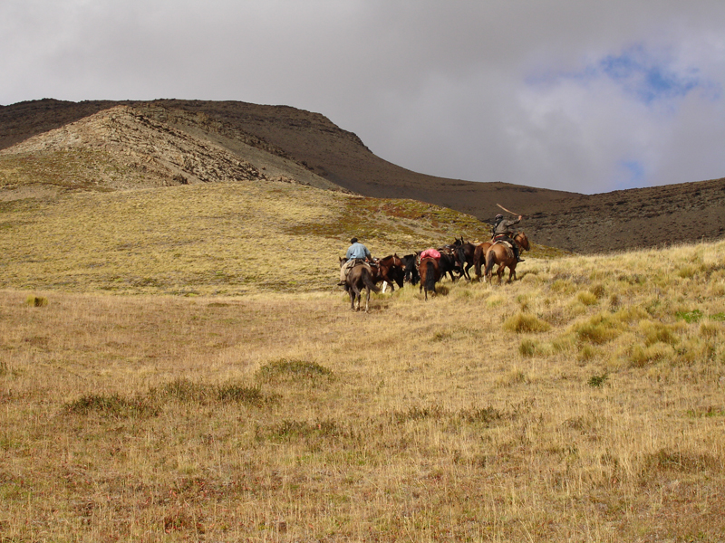
A few km north of the confluence, we would have to leave our vehicle and get on horseback. Below are some photos from an excursion to Divisadero in 2005 (four of us, four pack horses, and two gauchos).
packing up the horses (photo from LC)
In the photo above that’s me looking on as the two gauchos we hired to take us to this site pack our gear into bags. These guys are experts at perfectly balancing out the load on the pack horses … we just needed to stay out of their way. Note the craptacular weather … not windy (for once), but drizzly and probably about 45 degrees Farenheit.
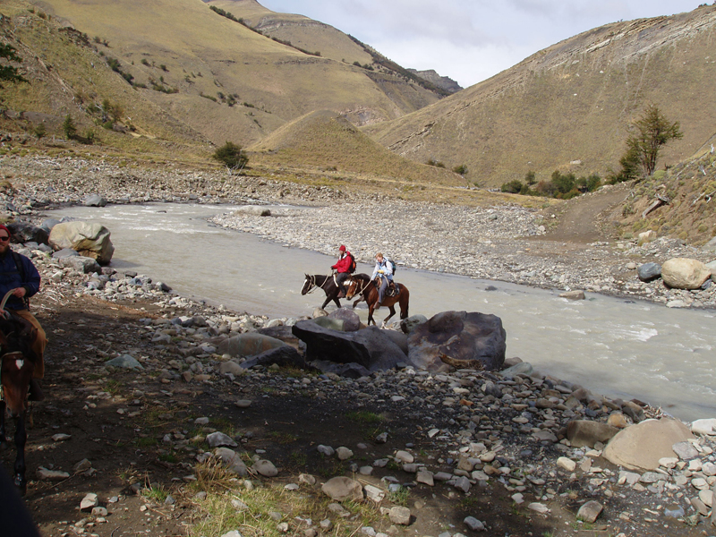
crossing Rio Zamora (photo from JAC)
The weather got better and better during this particular ride. Why did we have to take horses? The photo above is why – there’s an old road going right through that stream crossing. Nobody really uses the road anymore so, even if you could get across here without too much trouble (it’s quite low in this photo), the road is not maintained and there are several stretches that are impassable. Note the cute turbidite beds peeking out of cliff in the upper right.
The horse journey takes 3-4 hours with a thrilling terrifying last hour or so that is cross country through patches of woods and steep gully crossings. That was always the time I felt a bit ‘old-school’ for a short time because we’d be trotting across the pampas looking up at the ridgeline and sharing observations about the geology. Although those moments of sepia-toned geo-romanticism would be interrupted every few minutes by feelings that I might perish at any moment due to the whims of a 700-pound animal.
the gauchos leave us at Divisadero (photo from JAC)
The gauchos would drop us and all our gear off and then head back to civilization (i.e., a ranch in the middle of nowhere). For this particular excursion, we were staying for 11 nights. Basically, we set up the date for them to come back and get us … and that’s how it worked (we had a sat phone in case we needed to get out earlier than planned). In the photo above, that’s Chechin and Luis riding off with all the horses … leaving the four of us … in the middle of nowhere … for 12 days.
Finally! We’re there … after 20 hours of flying, a 3 hour drive to Natales, another 3 hour drive to meet the gauchos, and then 3-4 hours on horseback (and a lot of planning before and in between all these steps).
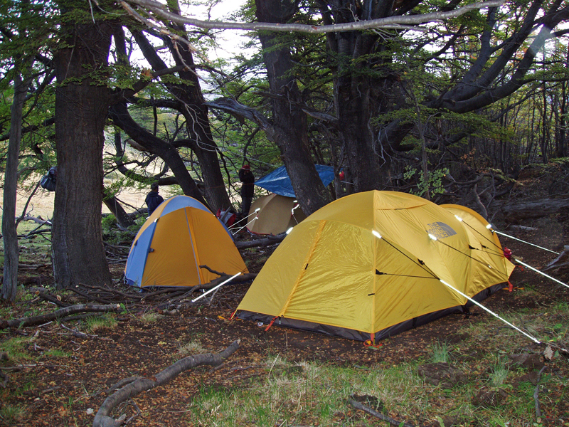
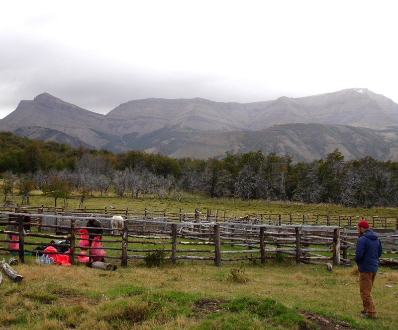
campsite at Cerro Divisadero (photo from JAC)
The photo above shows our campsite. Although difficult to see in this photo the reason this spot was chosen is because there’s small ridge behind and to the right of the tents that effectively blocks the wind. As many of you already know, Patagonia is ridiculously windy – finding a sheltered area to camp is crucial. The trees also provided a bit of extra cover for the rain and snow (although one trade-off is laying in your tent listening to the branches above creak and sway in the gusts of wind). The other key aspect of this spot is that it is only a 20-minute hike to the lowest outcrops (but a 2-hour hike to the top of the exposure). There’s something nice about living on the rocks you are studying.
What about the geology? I will put together another post about that soon … but, to whet your appetite, here’s a photo from near the top of the Cerro Divisadero ridgeline.

view to the northwest from Cerro Divisadero (© 2008 clasticdetritus.com)
Hey, that looks familiar!
~~~~~~~~~~~~~~~~~~~~~~~~~~~~~~~~~~~~~~~~~~~~~~~~~~~~~~~~~~~~~~
Sea-Floor Sunday #26: Global bathymetry map
There are several world maps that show bathymetry out on the internets available for download. Last week I came across one I had not seen yet.
GEBCO (General Bathymetric Chart of the Oceans) is an initiative joining the Intergovernmental Oceanographic Commission and International Hydrographic Organization.
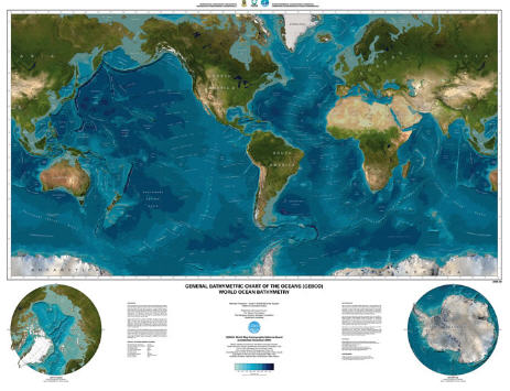
The image below is a low-resolution snapshot of the global map they created.
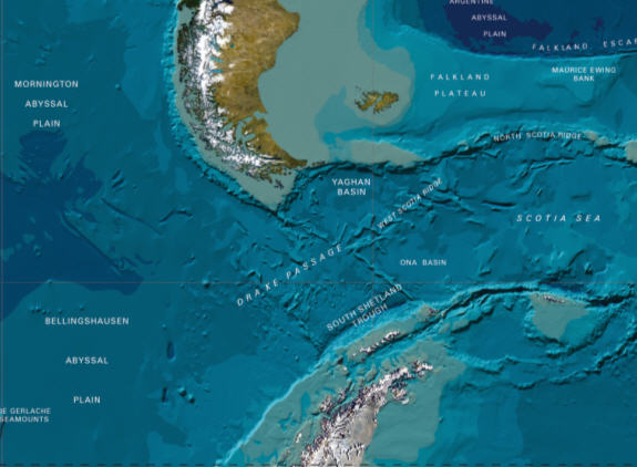
Here are a few close-ups showing some of the detail in this map.
What I like about this map is that the land parts of the map are from satellite imagery … makes a nice combination with the blue-themed bathymetry.
There’s low-resolution (3.6 MB) version and a beautiful high-resolution (32.5 MB) version … if you have access to a plotter, sneak it into the queue and put it on your wall.
You can find the images here.
~~~~~~~~~~~~~~~~~~~~~~~~~~~~~~~~~~~~~~~~~~~~~~~~~~~~~~~~~~~~~~~~~~
Some geoblogospheric reading
I haven’t done a roundup of goings-on in the geoscience blogging world in a long time. There’s a lot of good stuff out there these days. Here is but a small sampling:
– Olelog has a great post about the Cretaceous oceanic anoxic events.
– MJC Rocks continues his series on the Colorado Plateau geology.
– Silver Fox continues to share photographs of life and work in ever-widening Nevada.
– Lab Lemming shows us an outback sunrise.
– Andrew is adding to his collection of photos and information about the geology of the California coast.
– The Lost Geologist shares some stories and photos from a trip in Romania.
– Ron is back blogging and showing off his Gigapan images (Durango, Colorado and Split Mountain anticline).
– Rising to the Occasion is back on the blogging scene.
~~~~~~~~~~~~~~~~~~~~~~~~~~~~~~~~~~~~~~~~~~~~~~~~~~~~~~~~~~~~~~~
Session at AGU 2008 meeting
I just received notification that a session proposal that a colleague and I submitted for the 2008 AGU meeting (Dec 15-19 in San Francisco, CA) was accepted. Booyah!
I have not chaired an AGU session before, so I am excited … I love the AGU meeting. I’m also excited about the topic. My background and experience is in the observation and interpretation of natural depositional systems. My colleague and co-chair is involved in designing and analyzing experimental depositional systems (similar to these). There is a lot to be learned by comparing and contrasting the approaches and results. We are hoping to get a good mix of researchers that are active in this field.
Here’s the session description from the AGU meeting website:
–
Natural and Experimental Depositional Landscapes and Stratigraphic Architecture: Bridging the Gap Between the Surface and Subsurface
This session aims to characterize net-depositional landscapes from natural systems and numerical/physical experiments in an effort to link surface form and process with the depositional record. Given the wide array of remote sensing techniques and available data sets, such as 3D seismic-reflection surveys, a primary objective is to discuss landscape evolution in both a forward and inverse sense. Forward-based research will focus on landscape geometry and kinematics with special emphasis on the linkages between the channel network structure, channel migration, and sediment routing, which are critical components for predicting the spatial distribution of deposition and erosion. Inverse-based research will focus on extracting time-integrated landscape evolution via the preserved depositional record (from subsurface and/or outcrop). Our hope is that overlap between forward and inverse methods, when layered on the broad range of spatial and temporal scales comprising the session, will provide a first step towards linking surface evolution under net-depositional conditions with patterns observed in the stratigraphic record.
–
If this is within your area of expertise, please consider submitting an abstract (deadline is September 10th, 2008). I will post another reminder next month.
~~~~~~~~~~~~~~~~~~~~~~~~~~~~~~~~~~~~~~~~~~~~~~~~~~~~~~~~~~~~~~~
This week’s Friday Field Foto heads back down to southern South America.
While doing my own PhD work down there, I had the opportunity to help out another student with his project on the underlying formation in the basin filling succession.
The Upper Cretaceous Cerro Toro Formation is well-known among sedimentologists for the spectacularly-exposed conglomerate member. These conglomerates were deposited in a marine basin in water depths of at least 1500 m (5000 ft) (based on foraminifera in overlying shale).
The conglomerates are turbidites and fill a ~5 km-wide channel belt that ran along the axis of the elongate foreland basin. Picture the submarine channel system running along the axis of Chile trench (althought that is in the subduction zone trench, whereas this would’ve been in the foredeep on the other side of the arc … but you get the idea).
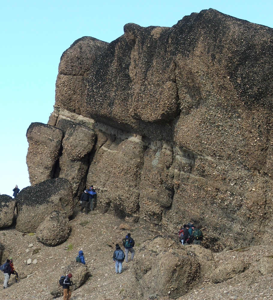
In the photo above, note the two nearly-equal thickness packages – a lower one dominated by traction structures (the nearly-horizontal stratification) and some sandstone lenses, and an upper, more massive, package. The clasts are generally pebble to cobble sized and mostly Paleozoic metasedimentary rocks.
I’m second author on a recent paper in Sedimentology about this system. I am absolutely swamped right now and haven’t found the time to put together a good post about the study … stay tuned.
In the meantime, here’s the abstract:
Deep-water foreland basin deposits of the Cerro Toro Formation, Magallanes basin, Chile: architectural elements of a sinuous basin axial channel belt (Sedimentology, v. 55, doi: 10.1111/j/1365-3091.2007.00948 )
Coarse-grained deep-water strata of the Cerro Toro Formation in the Cordillera Manuel Señoret, southern Chile, represent the deposits of a major channel belt (4 to 8 km wide by >100 km long) that occupied the foredeep of the Magallanes basin during the Late Cretaceous. Channel belt deposits comprise a ca 400 m thick conglomeratic interval (informally named the ‘Lago Sofia Member’) encased in bathyal fine-grained units. Facies of the Lago Sofia Member include sandy matrix conglomerate (that show evidence of traction-dominated deposition and sedimentation from turbulent gravity flows), muddy matrix conglomerate (graded units interpreted as coarse-grained slurry-flow deposits) and massive sandstone beds (high-density turbidity current deposits). Interbedded sandstone and mudstone intervals are present locally, interpreted as inner levée deposits. The channel belt was characterized by a low sinuousity planform architecture, as inferred from outcrop mapping and extensive palaeocurrent measurements. Laterally adjacent to the Lago Sofia Member are interbedded mudstone and sandstone facies derived from gravity flows that spilled over the channel belt margin. A levée interpretation for these fine-grained units is based on several observations, which include: (i) palaeocurrent measurements that indicate flows diverged (50° to 100°) once they spilled over the confining channel margin; (ii) sandstone beds progressively thin, away from the channel belt margin; (iii) evidence that the eroded channel base was not very well indurated, including a stepped margin and injection of coarse-grained channel material into surrounding fine-grained units; and (iv) the presence of sedimentary features common to levées, including slumped units inferring depositional slopes dipping away from the channel margin, lenticular sandstone beds thinning distally from the channel margin, soft sediment deformation and climbing ripples. The tectonic setting and foredeep architecture influenced deposition in the axial channel belt. A significant downstream constriction of the channel belt is reflected by a transition from more tabular units to an internal architecture dominated by lenticular beds associated with a substantially increased degree of scour. Differential propagation of the fold-thrust belt from the west is speculated to have had a major control on basin, and subsequently channel, width. The confining influence of the basin slopes that paralleled the channel belt, as well as the likelihood that numerous conduits fed into the basin along the length of the active fold-thrust belt to the west, suggest that proximal–distal relationships observed from large channels in passive margin settings are not necessarily applicable to axial channels in elongate basins.
–
Happy Friday!
~~~~~~~~~~~~~~~~~~~~~~~~~~~~~~~~~~~~~~~~~~~~~~~~~~~~~~~~~~~~~~~~~~~~~~~~
Papers I’m Reading – July 2008
In June I started a monthly series of simply listing some journal papers/articles I’m either reading, have read, or hope to find time to read. Four are from this year and one is an oldie but a goodie. I may add to it before the end of the month.
Here’s my list for July 2008:
- Saller, A., et al., 2008, Characteristics of Pleistocene deep-water fan lobes and their application to an upper Miocene reservoir model, offshore East Kalimantan, Indonesia: AAPG Bulletin, v. 92, p. 919-949 [link].
- Straub, K.M., et al., 2008, Interactions between turbidity currents and topography in aggrading sinuous submarine channels: A laboratory study: GSA Bulletin, v. 120, p. 368-385 [link].
- Heard, T.G. and Pickering, K.T., 2008, Trace fossils as diagnostic indicators of deep-marine environments, Middle Eocene Ainsa-Jaca basin, Spanish Pyrenees: Sedimentology, v. 55, p. 809-844 [link].
- Scott, A.C., et al., 2008, Temperature proxy data and their significance for the understanding of pyroclastic density currents: Geology, v. 36, p. 143-146 [link].
- Heezen, B.C. and Ewing, M., 1952, Turbidity currents and submarine slumps, and the 1929 Grand Banks earthquake: American Journal of Science, v. 250, p. 849-873 [could not find digital version].
~~~~~~~~~~~~~~~~~~~~~~~~~~~~~~~~~~~~~~~~~~~~~~~~~~
Sea-Floor Sunday #25: West African continental margin
I apologize for the drop in frequency and quality of my blogging lately … I have a bunch of paper revisions that are all converging at once that I need to get done (in addition to my day job).
–
Today’s Sea-Floor Sunday image is neither a bathymetry (sea-floor topography) image nor a photograph. Today’s example is a fantastic line drawing from a 1964 paper about the Congo submarine canyon by Heezen et al. One degree of latitude is approximately 110 km, so this image spans over 2,400 km (1,400 mi) in the north-south direction. This image is near the beginning of the paper and provides context for the rest of the paper.

(© AAPG)
The Niger Delta is in the upper left of the image and the offshore/onshore volcanic chain immediately to the south is known as the ‘Cameroon line’. The subject of this particular paper is the Congo submarine canyon, which is the prominent submarine drainage system at ~6 degrees S. The Congo system is interesting because, unlike the Niger to the north, there is no large delta being constructed. The Congo river is directly connected to the head of the submarine canyon. For those interested in the transfer of terrigenous sediment (i.e., derived from continent) to the deep sea, this situation has some interesting implications regarding transport mechanisms. I’ll put together a more detailed post sometime soon.
You don’t see line drawings like this as much these days (this one by line artist Marie Tharp). While I certainly love the resolution that modern multibeam bathymetry technology can produce, there’s something to be said about an image that combines science (i.e., constrained by observations/data) with aesthetics. The monographs of Ernst Haeckel are a superb example of this.
–
Heezen, B.C., Menzies, R.J., Schneider, E.D., Ewing, W.M., and Granelli, N.C.L., 1964, Congo submarine canyon: AAPG Bulletin, v. 48, no. 7, p. 1126-1149.
~~~~~~~~~~~~~~~~~~~~~~~~~~~~~~~~~~~~~~~~~~~~~~~~~~~~~~~~~~~~~~~~~~~~~~
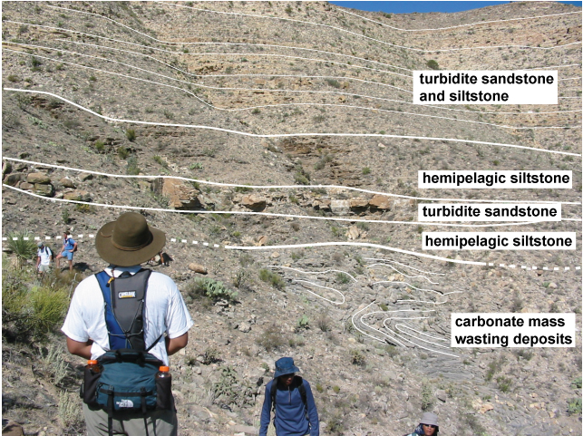
Friday Field Foto #58: Geopuzzle – Interpret this!
This week’s Friday Field Foto is a geopuzzle … tell me something about the stratigraphy shown in this photograph in the comments below correctly and you win! What do you win? Nothing … sorry, I still haven’t made those t-shirts … someday.
In addition to the challenge of interpreting the geology, part of the challenge is trying to see as much as you can. These aren’t 100% exposed … there are some (sharp) plants and talus slopes covering bits and pieces.

Part of winning is being able to describe what you’re looking at in this photo … use reference points and other ‘landmarks’ in the photo to point out specific features.
Good luck and Happy Friday!!
UPDATE: Annotated with very basic interpretation
~~~~~~~~~~~~~~~~~~~~~~~~~~~~~~~~~~~~~~~~~~~~~~~~~~~~~~~~~~~~~~~~~~~~~~~~~~~~~
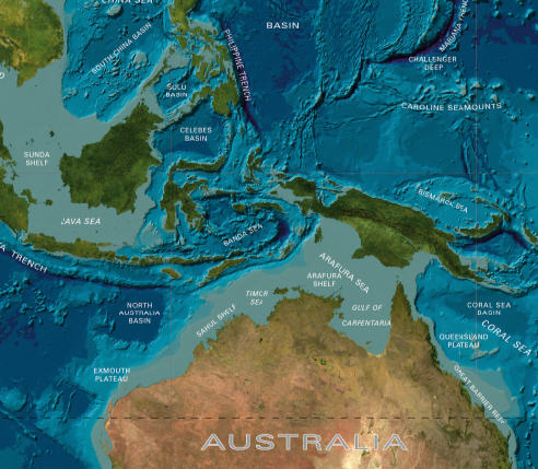
Sea-Floor Sunday #24: Marianas Trench
Back to some larger-scale images highlighting plate teconic features for this week’s Sea-Floor Sunday. I came across a great website from University of New Hampshire for more bathymetric (sea-floor topography) images.
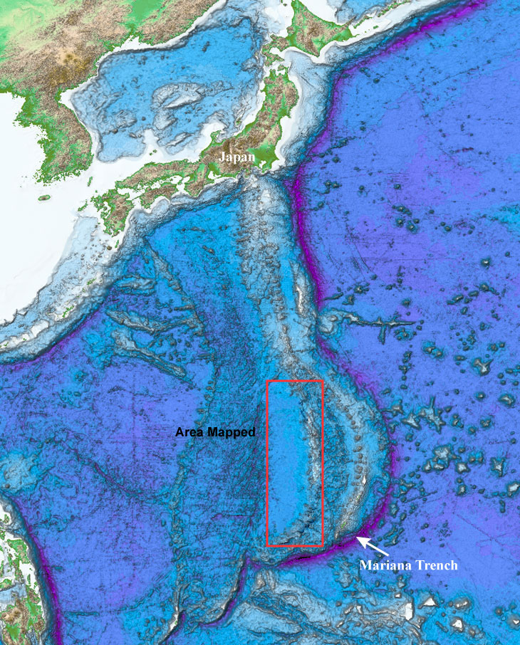
To see more images of this area, including within the red box shown on this map (which shows the back-arc region very nicely), check out this page on that same website linked to above.
