Friday Field Foto #58: Geopuzzle – Interpret this!
This week’s Friday Field Foto is a geopuzzle … tell me something about the stratigraphy shown in this photograph in the comments below correctly and you win! What do you win? Nothing … sorry, I still haven’t made those t-shirts … someday.
In addition to the challenge of interpreting the geology, part of the challenge is trying to see as much as you can. These aren’t 100% exposed … there are some (sharp) plants and talus slopes covering bits and pieces.

Part of winning is being able to describe what you’re looking at in this photo … use reference points and other ‘landmarks’ in the photo to point out specific features.
Good luck and Happy Friday!!
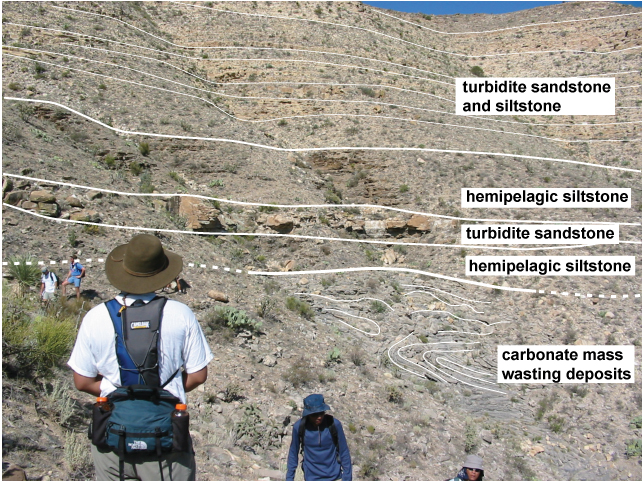
UPDATE: Annotated with very basic interpretation
~~~~~~~~~~~~~~~~~~~~~~~~~~~~~~~~~~~~~~~~~~~~~~~~~~~~~~~~~~~~~~~~~~~~~~~~~~~~~

Brian,
How about this…
– Submarine debris slide, contorted mass transport deposit [Camelbak Beds].
– Channel/levee facies, comprising:
+ Interbedded muds and sand {Fedora Beds].
+ Massive thinning out channel sand.
+ Channel levee mudstone [Brown Vegetation Beds].
– Overlain by laterally extensive sheet submarine sands and muds [Spiky Gamma Ray Member] with occasional channel development (e.g 20% from top centre).
Richard.
Richard … nice work … yeah, you got it! That was a lot more detail than I thought I’d get.
These are Permian rocks in the Delaware Mts of west Texas. The gray contorted strata are mass wasting deposits of the Cutoff Fm, which are thin-bedded carbonate beds that have been folded and such from slumping. The interbedded sands/muds (your Fedora member) is the lithostratigraphic base of the Brushy Canyon Fm and is called the “Pipeline Sh” member … it is typically a really dark siltstone recording a condensed interval before the sands above really kick in. Then there is that relatively isolated thick, massive sand you pointed out. When you follow this unit to the left and off the photo it pinches out onto the dark siltstone. Then that is overlain by more of the dark siltstone (there are arguments about whether it’s levee facies or not). In other areas, the “Pipeline Sh” does not have sandstone bodies within it, in this particular area, it does. And then, above that, sandstone intervals are more common and contain, as you point out, a mix of channel-filling bodies and more sheet-like bodies typical of the Brushy Canyon.
This is a great exercise. Thanks Richard for seeing so much. I can see the rocks, but I can’t always put it together as well as you.
I see a moderately warm day, in which most people ditch their sleeves but the guy who got the snot burned out of him on day one keeps his parka on.
Any chance you can put up an annotated image for those of us with a lousy eye for sedimentary facies?
Lab Lemming … that’s a good idea … I will put an annotated photo up later today.