Sea-Floor Sunday #10: Puerto Rico Trench
UPDATE: Also see this post from December 2009 of higher-resolution bathymetric images from the same region.
–
I guess I’m feeling subductive this week (see Friday Field Foto #40). The bathymetric image for today is a perspective view (looking west) of the North American and Caribbean plate boundary focused on the northeast part of the Caribbean Plate.
The image below is from the Caribbean earthquake and tsunami hazards studies page of the USGS’s Woods Hole Science Center.
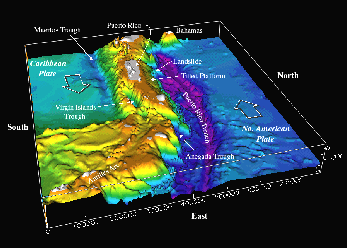
The Puerto Rico Trench reaches water depths greater than 8 km making it the deepest part of the Atlantic Ocean (the Marianas Trench gets to 11 km in case you’re wondering). The North American Plate is subducting underneath Caribbean Plate. In the view above, the main subduction zone where the plate motions are more orthogonal are further south. This view is where the arc starts to curve around to the west.
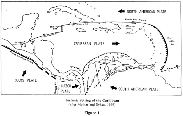
This map below (found here) shows a simplified map of the region and the primary tectonic boundaries. The bathymetric image above is the area where it says Puerto Rico Trench in the northeastern part of the Caribbean Plate.
A few years ago I went to the conference ‘Backbone of the Americas’ in Mendoza, Argentina. The conference was focused on the tectonics of both North and South America. One of the best talks I saw was by Pindell about the Caribbean area. It is quite a messy area tectonically with many aspects not fully agreed upon (which is fun!).
To find out more, this page is GoogleScholar with Pindell as author. There’s tons of stuff there to check out.
~
See all Sea Floor Sunday posts here.
Trackbacks
- Sea-Floor Sunday #58: Northern Puerto Rican margin - Tech News Archive
- "There Is A Profound Human Urge To Connect With Other People - The Internet Nomad
- She Cited As An Example A Group Of Women In West Africa Who Produce Shea Butter, A Plant-based Product Used For Cosmetics And For Food Such As Margarine - Hot News In Tech
- At The Store, The Phone Takes A Picture Of The Bar Code, Which Includes An Embedded URL, And The Phone's Screen Is Redirected To A Website That Hosts The Clips - Hot News In Tech

Thanks for highlighting our work. Let me also refer you to woodshole.er.usgs.gov/project-pages/Caribbean where you can download many more images and watches snippets of a movie about the seafloor.
Best, Uri
Uri … thanks for coming by and thanks for the link. Those are some fantastic images!
This is amazing. I love looking at pictures of geology.
I notice that the curve of the Yucatan penninsular is very near the conjunction of two plate. Can anyone tell me if there is evidence of plate movement disruption, or increase of movement calulcations due to the asteroid impact just north of the Yucatan Penninsula.
It seems that such an impact would potential alter the stresses that are transmitted due to the fracture of the impact basin.
If anyone knows, please email me.
thanks
Stephanie R
Thank you for this awesome resource! I have a growing interest in bathymetry, but come here with nearly zero knowledge. You’re posts and media are stunning and understandable even for the newbie!