Some photos from Peyto Lake, Canadian Rockies
Ever since I saw Hindered Settling’s fantastic post about the delta at Peyto Lake (Alberta, Canada) I wanted to go visit it. A trip up to Alberta and B.C. back in August got me close but, unfortunately, we did not have time to hike down and get closer to the delta. So I only have these photos from the viewing area. Enjoy!

Peyto Lake, Alberta, Canada (© 2008 clasticdetritus.com)

Peyto Lake delta, Alberta, Canada (© 2008 clasticdetritus.com)

Peyto Lake delta, Alberta, Canada (© 2008 clasticdetritus.com)

Peyto Lake delta, Alberta, Canada (© 2008 clasticdetritus.com)

Peyto Lake, Alberta, Canada (© 2008 clasticdetritus.com)
Hindered Settling followed up the original post with more (here and here) … if this lacustrine delta intrigues you as much as it does me, I encourage you to go read those posts.
~~~~~~~~~~~~~~~~~~~~~~~~~~~~~~~~~~~~~~~~~~~~~~~~~~
Sea-Floor Sunday #31: Lake Erie bathymetry
I guess technically this isn’t the sea floor … but hey, lakes are cool too!
–
This week’s image is a bathymetric map of Lake Erie, which is one of the Great Lakes in the northern United States. You can find the image and links to more information here.

Bathymetry of Lake Erie -- credit: NOAA NGDC (http://www.ngdc.noaa.gov/mgg/greatlakes/erie.html)
To give you a sense of scale, Lake Erie is ~330 km (200 mi) long.
Note how the central and eastern parts of the lake are subdivided into two distinct basins. I think – but could be wrong – that the bathymetric high separating them is a now drowned glacial moraine deposit.
–
See all Sea-Floor Sunday posts here.
~~~~~~~~~~~~~~~~~~~~~~~~~~~~~~~~~~~~~~~~~~~~~~~~~~
The Me Meme
I’ve been tagged for a meme, this time by Chris … okay here are the instructions:
- Take a picture of yourself right now.
- Don’t change your clothes, don’t fix your hair…just take a picture.
- Post that picture with NO editing.
- Post these instructions with your picture.
I don’t have one of these fancy-schmancy computers with a camera built in, but what I did have next to me was my cell phone with it’s craptacular quality … but, hey that’s what it is.

I took this last night when I first saw I was tagged (note the darkness outside behind me), but just now got a chance to post it.
Let’s see … I tag Chris (of goodSchist.com) and Dave of the relatively new Sedline News blog.
~~~~~~~~~~~~~~~~~~~~~~~~~~~~~~~~~~~~~~~~~~~~~~~~~~
Friday Field Foto #66: Puente del Inca (near Mendoza, Argentina)
In 2006 I had the opportunity to go to a geology conference in Mendoza, Argentina on my way back from field work in Patagonia. Part of this conference, called ‘Backbone of the Americas’, was a day trip from Mendoza at the foot of the Andes up to a view of the highest peak in the western hemisphere, Aconcongua.
The point of the trip was to check out the fold-thrust belt structure of the Andean Cordillera. Along the way we stopped at a popular attraction called Puente del Inca.

Puente del Inca, Argentina (© 2008 clasticdetritus.com)
To be perfectly honest, I know essentially nothing about this place … it was a really quick stop (and I haven’t tried Googling it either … yeah, I’m lazy).
If anyone knows more about this place – both the natural and human-made structure – please comment below.
Happy Friday!
–
see this older Friday Field Foto from this trip here
~~~~~~~~~~~~~~~~~~~~~~~~~~~~~~~~~~~~~~~~~~~~~~~~~~
My 2nd Blogiversary!
Callan’s recent post about the results of his geoscience blogging survey reminded me that my second year of blogging was coming to a close … I nearly forgot!
It’s been two years (September 2006) since I started blogging. The first year was version 1.0 (called …Or Something) and hosted on Blogger (blogspot) … remember that? Then about a year ago I redesigned it, changed the name, bought my own domain, and switched software (from blogspot to wordpress).
For my first blogiversary I did a stratigraphic analysis of this blog. After all, a weblog is simply a website with dated posts in reverse-chronological order … youngest on top, oldest on bottom.
This year, I don’t really have a detailed account of the last year of posts … but, what I do have are some visitor stats. I’ve been fortunate to have gained a lot of regular readers (per # subscribers in GoogleReader) as well as visitors from elsewhere on the internets.
The graph below shows monthly visitors for the past year.

This past month (September 2008) just barely beat out the previous winning month, July 2008, with 16,500 unique visitors! Note the dropoff in visitors in August … this is what happens when you stop blogging for a couple weeks.
A lot of these visitors are finding their way here via search engine terms searching for various things like “daisetta sinkhole”, “puerto rico trench”, “outer continental shelf”, “turbidites”, “sedimentary structures”, and “wheeler diagram”.
I doubt that most of these visitors stick around for the long haul … perhaps they find the nugget of information, image, or link they were looking for and move on. Those that have found me by random searches and are now regular readers, welcome!
And to my long-time regular readers, commenters, and fellow geobloggers — thanks for keeping me in your online reading routines!
~~~~~~~~~~~~~~~~~~~~~~~~~~~~~~~~~~~~~~~~~~~~~~~~~~
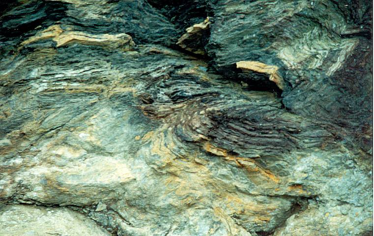
Friday Field Foto #65: Geopuzzle!
I was reading Callan’s fantastic summary of his geoblogosphere survey and was reminded about how fun geopuzzles can be. So, this week’s Friday Field Foto is a geopuzzle.
Your goal is to be the first to describe what is going on with this rock … I’m gonna leave it at that, no clues.

To make it a bit more difficult there is no scale shown (on purpose).
Happy Friday!
~
UPDATE (9/30/2008): Answer!
Silver Fox basically got it right … and Andrew knows me too well – these are, of course, turbidites. This particular image is of mudstone-rich deposits with one silty bed in it. Stratigraphic up is to the left and the entire image is about one meter across.

The diagonal lineaments (from upper left to lower right) are fractures that, we were told, are related to the uplift of these ~600 million year-old rocks during the Mesozoic. The very obvious, nearly horizontal lineaments are very recent glacial striations.
If you want to learn more about this outcrop (Canadian Rockies), see this post for details and more photographs.
~~~~~~~~~~~~~~~~~~~~~~~~~~~~~~~~~~~~~~~~~~~~~~~~~~
The Accretionary Wedge #13: Fluvial deposits on Mars
Note: This post is part of the geoscience blog carnival, The Accretionary Wedge #13: Geology in Spaaaace!, hosted by goodSchist this month.
Actually, I guess this is more geology from space.
I’m cheating just a little bit because I’ve posted about these images before … but it was a year and a half ago and they are that cool that it’s worth doing again. The images below are from a 2003 Science paper by Malin et al. detailing fascinating landforms on the surface of Mars. You can also see these and more images on the Mars Global Surveyor site here.
High-resolution mapping of planet surfaces (including Earth) from orbiting spacecraft is revealing the beauty and complexity of erosional and depositional landforms. The better resolution (in some cases sub-meter) allows researchers to gain a more comprehensive appreciation of the scales of features. Images from space provide the large-scale context while also revealing intricate details.
These particular images are from what are interpreted to be ancient river and delta deposits exposed on the surface of Mars. This area is known as the Eberswalde Delta (contained within the crater of the same name).

Malin et al. (2003); Science
In the image above note the branching and spreading out of the curvilinear features from left to right. This is called a distributive pattern and is an important criterion for recognizing sediment deltas and fans (alluvial, submarine).
Besides the fact that rivers and deltas are awesome and here are some examples from another planet … these particular exposures are unique in that they are revealed in inverted topography. That is, the channel deposits (which presumably have coarser-grained material in them) were more resistant to subsequent erosion so now they are positive topographic features (ridges, mesas, plateaus).

Malin et al. (2003); Science
Note the criss-crossing of the channel features in the image above.

Malin et al. (2003); Science
The image above is my favorite. Take a look. See it? Yes … an ancient meander loop on Mars! How cool is that?!
Compare to this nice image of Mississippi River meander loops here on Earth. While these are certainly different scales, the form and patterns are very similar. If you looked around on GoogleEarth, I’m sure you could find a nearly identical analog (if you do, let me know in the comments).

Mississippi River (credit: Nasa Earth Observatory)
Now, the next step is to go ground-truth those Mars features … I would love to be able to walk around and check out the vertical cross-sectional view of those inverted channel-fills.
~~~~~~~~~~~~~~~~~~~~~~~~~~~~~~~~~~~~~~~~~~~~~~~~~~
Sea-Floor Sunday #30: Submarine channels, deep-water Nigeria
In case you missed it, check out my post from last week about a relatively new online source of geoscience information and images, the Virtual Seismic Atlas.
One of the coolest parts of a 3D seismic-reflection survey is the very detailed map of the sea floor.

credit: Virtual Seismic Atlas (http://www.seismicatlas.org/)
This image is a perspective image of the sea floor in deep water offshore the Niger Delta. The most prominent features are the submarine channels cutting across the slope. Also note the narrow ridge that is roughly perpendicular to the channel trend (near the green-gray boundary by color). These ridges are compressional features caused by folding and thrust-faulting of the underlying sediment. The upper part of the slope on continental margin deltas such as the Niger will typically have extensional (i.e., normal) faults – in deeper water near the lower slope or base-of-slope, that updip extension is balanced by a compressional zone. Also note the scale of these submarine channel systems (scale bar on lower left) … these suckers are big.
Here’s the blurb about this image directly from the VSA site:
Sea bed images derived from 3D seismic for part of deep-water Western Niger Delta. The submarine canyons carve through ridges that are underlain by anticlines that represent part of the deep-water fold thrust belt. Various generations of canyons can be identified on the basis of cross-cutting relationships.
See the original image from VSA here.
–
Note: All images above are property of Virtual Seismic Atlas (VSA). They are available for personal or educational purposes, but please visit their site and read terms of use [pdf] before doing so.
~~~~~~~~~~~~~~~~~~~~~~~~~~~~~~~~~~~~~~~~~~~~~~~~~~
Friday Field Foto #64: Nice ‘Z’ fold in Patagonian outcrop
Here’s another one for the structural geology fans out there.
This is a photo of a cute little ‘Z’ fold in some Cretaceous strata in Patagonia (from this place).

Cretaceous Tres Pasos Formation, southern Chile (© 2008 clasticdetritus.com)
Sedimentologists and stratigraphers will typically try and find outcrops that lack structural deformation. This is because one of our goals is to precisely reconstruct the distribution and layering of sedimentary rocks. If the rocks are all faulted, folded, fractured, or otherwise FUBARed this becomes very challenging.
But it’s important to point out that, the whole reason the outcrops are there in the first place is because of structural deformation. In the case above, a series of mountainside exposures are uplifted and dipping to the east (in photo above, note the overall tilt of strata to the left). Associated with that uplift was some localized and relatively small-scale reverse faults. In other words, we need some deformation to produce the outcrops (but I’d also point out that structural geologists love sedimentary rocks because it allows them to very precisely map structures).
In the example above, you can quite easily put that sandy package (which is about 20 m thick, by the way) back together. The other thing I like about this photo is how you can see the ‘Z’ repeated in the gully in the background.
Happy Friday!
~~~~~~~~~~~~~~~~~~~~~~~~~~~~~~~~~~~~~~~~~~~~~~~~~~
Papers I’m Reading – September 2008
Continuing on with the monthly theme of what peer-reviewed papers I am reading (or planning to read).
Here’s the list for September:
Check out June, July , and August lists.
~~~~~~~~~~~~~~~~~~~~~~~~~~~~~~~~~~~~~~~~~~~~~~~~~~
