Submarine fans during a highstand in sea level
![]() As I mentioned a few weeks back, I am a co-author on a paper in the September 2007 edition of Geology. The first author, a collaborator of mine, does not have a blog (he’s too busy publishing papers!), so I figured I would write a post about the paper here on Clastic Detritus.
As I mentioned a few weeks back, I am a co-author on a paper in the September 2007 edition of Geology. The first author, a collaborator of mine, does not have a blog (he’s too busy publishing papers!), so I figured I would write a post about the paper here on Clastic Detritus.
The title is: Highstand fans in the California Borderland: The overlooked deep-water depositional system
I’ll get into what highstand fans are in a moment. First, what is the California Borderland? The NOAA topography-bathymetry map below shows a continental-scale view of the southwestern part of North America. The California Continental Borderland is that rhomb-shaped area offshore and south of the big bend in the San Andreas transform margin. It extends southward offshore of Baja California but the offshore part narrows considerably.
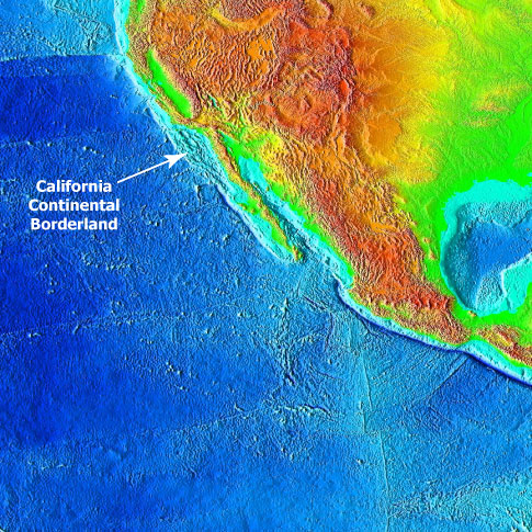
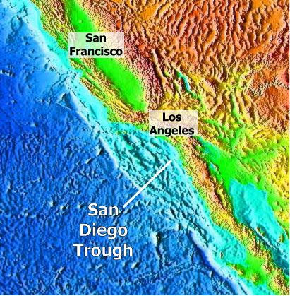
The next image (below) zooms in a bit and nicely shows the pockmarked nature of the Borderland (area in the lighter blue color). The crust in this area experienced some extension (stretching) ~10-15 million years ago (give or take) producing deep basins bounded by normal faults. In the last few million years, compression related to the evolving San Andreas system reactivated some of these normal faults into reverse faults and thrust faults. So now, these deep basins are bounded by some uplifting submarine ridges, some of which pop out of the ocean as the Channel Islands. To see a perspective view of the Borderland, check out this post from several months ago. We have been studying the basins directly adjacent to the present coastline and the sediments that fill them. The Highstand Fans paper focuses on the systems in the San Diego Trough.
Okay…that is a brief background on the setting of the Borderland region. If you want to learn more about the San Andreas Fault system and see more diagrams showing exactly where it goes, check out this USGS website.
So, the whole point of this paper is to highlight that submarine fans do indeed form and grow during highstands of sea level. Traditional sequence stratigraphic models typically show that significant sediment bypass from onshore to way offshore, in the deep-marine realm, occurs when sea level is low (called “lowstand”).
Below are some idealized figures showing the difference between lowstand and highstand within the context of conventional sequence stratigraphic models. I annotated these images, which are from the fantastic Univ of South Carolina sequence stratigraphy website.


As I said above, when sea level is low, coarse-grained sediment bypasses the exposed shelf and accumulates in deep-water as a submarine fan. During highstands of sea level, the coastal plain and shelf is accumulating sediment and the deep basin is starved resulting in no submarine fan growth.
The most important thing to remember is that these conceptual models were developed from data along passive margins (e.g., east coast of North America, west coast of Africa, etc.) where large sedimentary systems build out basinward (like the Mississippi delta is doing). In that context, the highstand vs. lowstand model does indeed work. There are certainly some exceptions, but by-and-large, this is not a horrible rule of thumb for passive continental margins.
For tectonically active continental margins, however, we have a completely different story. We, of course, are not the first to point this out. Several previous studies have documented the occurrence of turbidite deposition during the current highstand. With this paper, we wanted to go beyond documenting the presence of a system and dig a little deeper by analyzing volumes of sediment and rates of accumulation of both highstand and lowstand systems in one area.
Okay, so I’m going to attempt to lay all this out without a lot of jargon and extraneous information. There are three different submarine fan systems. The figure below shows the activity of these systems against the sea-level curve (black line) and oxygen isotope stages since 50 ka (50,000 years ago). When the black curve is low, sea level is low. Note that La Jolla system (light blue) is active during relative highstands whereas the other two are active during lowstands.
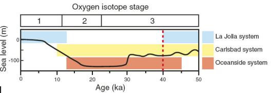
Using a tight grid of seismic-reflection profiles we (i.e., the first author) painstakingly correlated and mapped out the distribution of the three submarine fan systems. Radiocarbon ages from boreholes provide the constraint on timing and help confirm correlations. After all that, we calculated the sediment volumes and associated accumulation rates. We found that the highstand system (the light blue above) accumulated more sediment in a shorter time than the other two systems combined since 40 ka.
It gets even more interesting (to sed dorks like me, anyway) when you look at how these submarine fan systems are fed coarse-grained sediment. There are no large rivers dumping directly into the submarine canyons that feed the submarine fans. They get their sand from the beach. At present, La Jolla submarine canyon receives sand directly from the beach…the canyon head goes nearly right up to the beach. See this post from a while back showing a bathymetric image of La Jolla submarine canyon.
In this area, there is a north-to-south longshore drift (called a littoral cell) that transports sand along the beach. When a submarine canyon intersects the littoral cell…the beach sand has the potential to be carried down into the submarine canyon as a turbidity current and then deposited way offshore on a submarine fan. The image below from the paper shows the difference in littoral cell/submarine canyon activity during highstand vs. lowstand periods.

The left part of the figure shows that during the last lowstand (~20,000 years ago), the coastline was out at the current continental shelf edge. Numerous submarine canyons and gullies head at the shelf edge and were able to intersect sand from numerous littoral cells. During the more recent highstand in sea level, the shelf was flooded pushing the coastline back leaving the shelf-edge canyon heads stranded. In this situation, the littoral cell sand just keeps on going south until it is intersected by the La Jolla submarine canyon. So, all those smaller littoral cells are combined into one (called the Oceanside littoral cell) during the highstand. This results in one larger submarine fan instead of numerous smaller submarine fans.
So, in this situation not only does submarine growth occur during a highstand in sea level, the fan is more voluminous and accumulates sediment at a faster rate. Does this rock the foundation of sequence stratigraphy to its very core? Not really. But, as we point out in the paper, the application of the lowstand-only models is what is widespread. The sequence strat models themselves are not the issue…just the application of them to any and every turbidite system on the planet. The fact that tectonically active margins have relatively narrow continental shelves (10s of km) compared to passive margins (100s of km) is the fundamental difference.
An additional aspect of this kind of research relates to trying to quantify the volumes and rates of sediment transfer from onshore to offshore. Tectonic geomorphologists are busy calculating rates of erosion, denudation, and uplift in mountainous onshore areas (the source of sediment). The timing and distribution of sediment accumulation in the “sink” offshore needs to be integrated with the onshore work. Hopefully, getting at all these various rates (accumulation, erosion, denudation, uplift, subsidence, etc.) will lead us to a better understanding of the dynamics of continental margins.
–
Link to full text of pdf here (w/ subscription).
A Comment and Reply published in Geology came out in April 2008, see this post.
–
Covault, J., Normark, W., Romans, B., & Graham, S. (2007). Highstand fans in the California borderland: The overlooked deep-water depositional systems Geology, 35 (9) DOI: 10.1130/G23800A.1

Excellent post! I have spent most of my time in the Midwest and east, so I haven’t had much of a chance to focus on the amazing geology out west. That is a really fascinating system. I like your straight forward explanation about the Oceanside Littoral Cell creating one large fan instead of numerous smaller fans. I have done some work on the Bengal Fan and it is cool to see how on different scales there are similar processes occurring between the La Jolla Canyon and the Swatch of No Ground Canyon.
Have you been able to work out any estimates for fluid flow rates from the head of the canyon to the fan?
Keep up the excellent posts! I like the new setup.
Thanks Russell…I don’t know too much about the Bengal system (except that it is the single largest sediment accumulation on the planet!)…you should post about it sometime :)
You’ve probably seen the Kudrass et al. (1998) Geology paper about how storms and tides influence sediment transport into the Swatch of No Ground Canyon. Pretty cool.
As for your fluid flow rates question…do you mean for individual sediment gravity flow events? Or, whether or not there is temporary storage in the canyon head before getting down to fan?
Now that you mention it, I am curious about both. But I was initially asking about individual gravity flow events. I am always amazed at how quickly sediments move through these systems.
I have seen that paper, it is very cool. Kudrass is 2nd author on Michels et al. (1998) paper from Marine Geology about cyclone-dominated sedimentation patterns on the G-B submarine delta. I can’t say that I agree with it all, but they make some very interesting arguments for their position.
You might check out the Weber et al. 1997 Geology paper titled “Active growth of the Bengal Fan during sea-level rise and highstand” as it seems fairly relevant to your paper.
I am actually working up a post about some of my current research on the Ganges-Brahmaputra Delta, hopefully I’ll get it finished soon.
We don’t have information about the velocity of individual gravity flow events for Borderland systems. Direct measurements of turbidity currents (with current meters and such) is very difficult.
See the Paull et al. (2003) paper in Geo-Marine Letters about a turbidity current that was ‘caught in the act’ in Monterey submarine canyon…if I remember they were able to make some measurements. But, I think the current lifted up their heavy equipment off the canyon floor and then redeposited it several km down-canyon!
Without looking this stuff up, I recall that estimated/measured velocities for turb currents have a huge range…some are actually not as fast as one would think (few meters/sec), while others are an order of magnitude faster.
As for duration of sediment retention in the canyon head before being flushed down-system, this is also not very well known. But, as more and more ocean observation systems are being designed and deployed (e.g., NEPTUNE system out of U of Washington), I hope we can amass more direct measurements of these processes.
Yes, the Weber et al. ’97 paper is a good one…I need to remember to revisit that.
I enjoyed the highstand fans paper, and provided some input to Jake, as I have been studying these fans south of the border. My first comment is to make the point that the major Borderland faults are predominately strike-slip, like the San Andreas, with components of extension (mostly during Miocene) and shortening after shift of PAC-NOAM transform to southern San Andreas. I have a paper coming out this month, Geol Soc London, Special Publication on Tectonics of Strike-Slip Restraining and Releasing Bends–good examples of the basin and ridge formation during modern strike-slip faulting. Regarding flow rates in submarine canyons, Professor Francis Shepard wrote a book on the subject based on observations in Borderland and Baja California canyons and fans. Lastly, data from the Banda submarine canyon, near Ensenada, suggests that these canyons form by headward erosion of slope gullies that eventually may capture the littoral cell deposits. About a year or two ago, divers observed a significant change in bottom morphology at West End of Santa Catalina Island, suggesting active submarine landslide–unfortunately, no one has bothered to investigate further with side-scan sonar or multibeam to get dimensions and character.
Thanks for the great web-site, there are some spectacular things to see in the seafloor morphology (and subbottom structure, too).
Mark
Mark…thanks for coming by, glad you like the blog. I look forward to checking out your GSL paper.
Regarding submarine canyon head morphology and processes, Charlie Paull at MBARI continues to collect information from Monterey. Seems like each time we get more information we find out something we never knew…which is really exciting.
Hello Brian,
Great site – I like it. And I like your paper – I’m a big fan of questioning the lowstand model in the face of all sorts of various evidence. But do you really think the lowstand model is a good rule of thumb for passive margins? Like most elements of the sequence stratigraphic model, it lacks any substantive evidence or indeed theoretical basis, so I’m not so sure. I strongly suspect that many deltas can reach the shelf edge through normal progradation on most types of margin, and if this is the case, it is unlikely shelf-edge deltas are uniquely or even typically lowstand.
Anyway, keep up the good work with the site.
cheers, Pete
Peter … thanks for the kind words about this paper.
You say: “I strongly suspect that many deltas can reach the shelf edge through normal progradation on most types of margin, and if this is the case, it is unlikely shelf-edge deltas are uniquely or even typically lowstand.”
That’s a really good point. Just for the sake of discussion, while *some* deltas could get to shelf edge during non-lowstand conditions, wouldn’t *all* deltas be at the shelf edge during lowstand conditions?
In this way you’ll possess a good notion concerning the game play and you will additionally study
new types of playing.