Sea-Floor Sunday #21: Cyclic steps in the deep sea
After several larger-scale sea-floor images highlighting tectonic features, I’m going to zoom in a bit for today’s Sea-Floor Sunday and show you some very cool geomorphological features that develop on the sea floor.
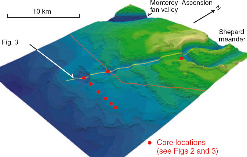
What the heck is a “cyclic step”? We’ll get to that later … first, I want to show a regional map to give you some context. The area we’ll look at in more detail is called the Shepard Meander, a huge meander bend in the Monterey submarine channel. In the map below, it is just barely on the image in the lower left (annotation mine). The Monterey submarine canyon, which is offshore of the central Californian coast, transitions from a canyon cut into the bedrock of the continental shelf to a submarine channel system off in deeper water that has both erosional and depositional features associated with it.

(MBARI 2003)
The rest of the images and much of the information for this post are from a 2006 paper in Sedimentology by Fildani et al. called “Channel formation by flow stripping: large-scale scour features along the Monterey East Channel and their relation to sediment waves”.
There is far too much in this paper to do justice to it in one blog post – I will simply be showing a few images of these very interesting features. I recommend you take a look at the paper if you want to get into the nitty-gritty.
So, let’s zoom in a bit on the Shepard Meander. Take a close look at this bathymetric map (Fig. 2 from their paper). Note the Shepard Meander in the upper right of the map. The width of this view is approximately 35 km.

(Fig. 2, Fildani et al., 2006)
The Shepard Meander is obvious and striking on this map, but the channel itself is not the focus of this paper. If you take another look at the map above, note the train of arcuate “scoop”-shaped scour features in the bathymetry. They are four prominent scours heading directly away from the bend in the channel and decreasing in relief away from the channel.
The next image below (Fig. 3 from the paper) shows the bathymetric profile, at 10x and 2x vertical exaggeration. Note the scale bar — these are huge features, each of them kilometers across.

(Fig. 3, Fildani et al., 2006)
Although the Monterey submarine channel (to the right in profiles above) is certainly eroding at the base of the channel, it is important to note that a component of the channel relief is because it has muddy/silty depositional levees that build up along the sides of the channel thalweg.
For yet another view of this train of scours, the image below (Fig. 5A from their paper) is a colored perspective image of the bathymetry with Shephard Meander on the right side of the image.
(Fig. 5A, Fildani et al., 2006)
What’s evident in this image (and if you go back to contour map above and look closely) are the depositional features on either side of the scour train. Although they appear “terraced” in the image above, this is a bit misleading because they are actually rather smooth depositional sediment waves – essentially a field of gigantic bedforms.
So, what’s going on here? We have a sediment wave field with a train of scours in the middle of it adjacent to and pointing away from a major bend in a submarine channel. If we go back to the title of the paper, they mention a process called flow stripping. This phenomenon, which was first discussed as an important process in the deep sea by Piper & Normark (1983), is best explained with an illustration.
(Fig. 7, Peakall et al., 2000)
An important aspect to remember about turbidity currents (i.e., sediment-laden, gravity-driven currents that occur in the submarine world) is that they can be thicker than the channel that confines them. As the turbidity current comes roaring down the channel and approaches a bend (see image above from Peakall et al., 2000), the lower part of the flow, which has the coarser material, will continue along the axis. The upper, typically more muddy, part of the flow is taller than this confinement so it “spills” out of the channel. In other words, the flow is stripped.
If you scroll up a bit and look at the images of the Shepard Meander and the associated sediment waves and scour train again, you can imagine this process occurring at the channel bend. So, the flow stripping process explains how sediment gets out the channel, but what about these scours?
At the risk of oversimplifying, essentially what is happening here is analogous to the formation of antidunes. If you remember back to your sed/strat class, antidunes are bedforms that typically develop under conditions of supercritical flow. As I mentioned above, please read the paper for the full story of the sedimentary processes and mechanics since, as always, this analogy can only be taken so far.
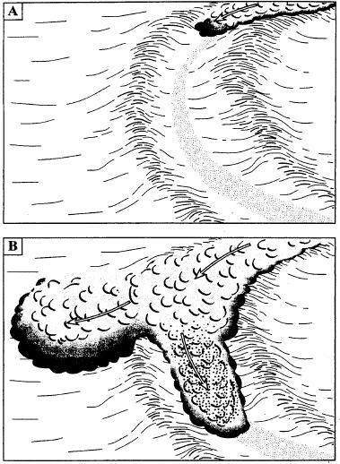
You may be thinking … well that makes sense for the sediment waves, but what about the scours? Finally, we get to the title of the paper. Cyclic steps are phenomena documented and studied by geomorphologists from bedrock channels. Basically, cyclic steps are erosional features produced by supercritical flow, whereas sediment waves are depositional features produced by supercritical flow.
Again, this is best communicated with an illustration. The photos below (Fig. 8 from Fildani et al., 2006) show examples of cyclic steps from a bedrock channel (A) and in a simulated bedrock channel (B).

(Fig. 8, Fildani et al., 2006)
To wrap this up … the final question is: why do these cyclic steps occur outside the submarine channel? This ties it back to the flow stripping process. As the top part of the turbidity current is stripped away from the main part of the flow at the bend it is (1) now going down a steeper gradient – the levee slope is steeper than the thalweg gradient and (2) the flow is all of the sudden a lot thinner. These two conditions contribute to the flow becoming supercritical.
As resolution of bathymetric mapping gets better and better, researchers are finding cyclic steps in other submarine fan systems around the world. One of the interesting implications is if these scour trains are incipient channels – that is, when the levee is finally breached fully, the new channel will find this pathway and develop in that position.
–
References:
Fildani, A., Normark, W.R., Kostic, S., and Parker, G., 2006, Channel formation by flow stripping: large-scale scour features along the Monterey East Channel and their relation to sediment waves: Sedimentology. doi: 10.1111/j.1365-3091.2006.00812.x
Peakall, J., McCaffrey, W., and Kneller, B., 2000, A process model for the evolution, morphology, and architecture of sinuous submarine channels: Journal of Sedimentary Research, v. 70, p. 434-448.
Piper, D.J.W. and Normark, W.R., 1983, Turbidite depositional patterns and flow characteristics, Navy submarine fan, California Borderland: Sedimentology, v. 30, p. 681-694.
Bathymetric image of regional Monterey Canyon area from this MBARI website.
~~~~~~~~~~~~~~~~~~~~~~~~~~~~~~~~~~~~~~~~~~~~~~~~~~~~~~~~~~~~~~~~~~~~~

Very interesting – and great graphics!
This would be a great post for ‘researchblogging.org’ — did you give up on using the icon?
zs … they’ve had issues getting wordpress.com blogs to work, but I think they fixed that … I simply haven’t tried it again … you’re right though, maybe I’ll do that
Another type of constructional steps – tufa barrages in bedrock channels (Viles et al 2007, Sedimentary Geology 195 39-53)
Really interesting post.. thanks.
I received this comment and decided to move it to this post because it’s the most recent post somewhat related to the question.
Monica asks: “Hi! in your experience…do u know any example of sediment waves on levees founded or described in outcrop?
thanks.”
Great question. My intutition is that some of the interpreted levee successions in outcrop do contain sediment waves. The issue is definitively recognizing them … a big problem is that these features are extremely subtle (100s to 1000s meters in wavelength and only several meters in amplitude). They are so apparent on bathymetric maps and seismic-reflection profiles because of vertical exaggeration. So, you would need a very big outcrop (at least a couple km) with the thin-bedded levee facies exposed perfectly (which is tough to find).
Off the top of my head, I can’t think of a paper/study that specifically discusses sediment waves in outcrop … I could do a bit of digging around if you’re still interested.
This, like many of your other photos, is an example of dendritic patterns from electrical discharge. You can’t possibly be looking at these forms and seeing erosion.