Friday Field Foto #81: Permian turbidites in the Karoo Basin
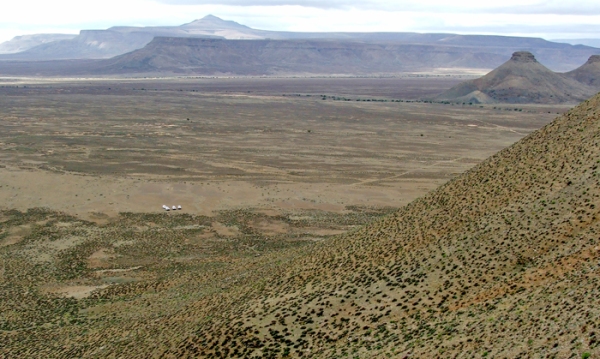
This week’s Friday Field Foto is from a trip to South Africa I went on about a year ago. We went to look at the relatively famous Permian turbidite outcrops in the Karoo basin.
The area pictured here is called the Tanqua Karoo, and is a spectacular place to examine a preserved submarine fan (note the small group of light-colored vehicles down in the valley). The cliff-forming rocks that form the mesas and buttes in the distance (and what I’m standing on taking this photo) are sandstone bodies that can be correlated across many 10s of km.
Check out photos from a wildlife reserve not too far from this area on this post.
Happy Friday!
~~~~~~~~~~~~~~~~~~~~~~~~~~~~~~~~~~~~~~~~~~~~~~~~~~
Q&A with yours truly on The Reef Tank blog
I was recently contacted by a blog called The Reef Tank, which is an online community of reef hobbyists interested in marine science.
In recent months they have been reaching out to scientists whose research deals with marine science and marine conservation issues. They’ve profiled climate scientists, oceanographers, ecologists, marine conservationists, and others.
They’ve expanded their interests to include marine geology, and in their first post on that subject they asked me some questions about my research interests and how the discipline of geology, which typically deals with longer time scales, intersects marine science.
Head on over and check out the Q&A and the rest of The Reef Tank blog — there’s a lot of good stuff.
~~~~~~~~~~~~~~~~~~~~~~~~~~~~~~~~~~~~~~~~~~~~~~~~~~
Sea-Floor Sunday #44: Bounty Trough, offshore New Zealand
One of the deep-marine sedimentary systems I’ve been wanting to learn more about is an area offshore of the east coast of the South Island of New Zealand.
Before showing you the image of the week, below is a map from GoogleEarth showing the location of the Bounty Trough, which is an east-west-trending trough interpreted as a remnant continental rift (bounded by the Chatham Rise to the north and the Campbell Plateau to the south).
The white box highlights the area shown in the image below. I’ve rotated the image (north is to the right) to take advantage of the more vertical layout of this blog. Warm colors (reds and oranges) are shallower water and cool colors (blues) are deeper water. The width of the image is approximately 230 km.

Bounty Trough, offshore New Zealand (credit: NSF Margins http://baby.indstate.edu/gomez/margins.html ;note - image is rotated, north is to the right)
Note the tributary submarine canyons/channels coalescing into a single axial conduit down-system.
Click on the image to go to the source and learn more.
–
Here are a couple of recent papers about this deep-marine sedimentary system. See references therein for much more:
- Uenzelmann-Neben et al., 2009, Neogene sediment structures in Bounty Trough, eastern New Zealand: Influence of magmatic and oceanic current activity: GSA Bulletin [link].
- Shapiro et al., 2007, Petrology and provenance of sand in the Bounty submarine fan, New Zealand: GSA Special Paper 420 [link].
–
To see all the Sea-Floor Sunday posts click here.
~~~~~~~~~~~~~~~~~~~~~~~~~~~~~~~~~~~~~~~~~~~~~~~~~~
Friday Field Foto #80: Thrust fault contact in Nevada
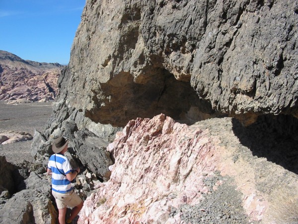
This week’s Friday Field Foto is a close-up view of the Keystone Thrust in southern Nevada.
The key criterion for correctly recognizing a thrust fault is to demonstrate that there are older rocks on top of younger rocks (assuming the whole thing isn’t upside down). In many cases, this isn’t necessarily straight-forward.
What’s great about the Keystone Thrust, at least in this location, is that dark gray Cambrian (540-490 Ma) limestones are on top of bright pinkish and buff-colored sandstones of the Jurassic (200-145 Ma) Aztec Formation. The contact is very easy to see!
Happy Friday!
–
see this older Friday Field Foto for a different view of this same outcrop
~~~~~~~~~~~~~~~~~~~~~~~~~~~~~~~~~~~~~~~~~~~~~~~~~~
Sorry for the lack of posts lately … to be perfectly honest, I’m in a blogging slump of late. Life is catching up with me and I simply haven’t found the time to finish up some posts. But don’t fret … I have numerous posts in ‘draft’ stage waiting to be finished.
–
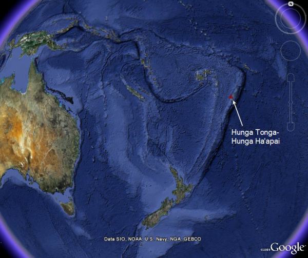
This week’s Sea-Floor Sunday shows some regional bathymetric images for the recent eruption of Hunga Tonga-Hunga Ha’apai* volcano along the Tonga volcanic arc. Check out coverage at both Eruptions and The Volcanism Blog for all the details and plenty of links to even more details.
The first image is from GoogleEarth and zoomed way out to give you global context.
Hunga Tonga-Hunga Ha’apai is toward the northern end of a subduction zone extending some 3,000 km south through the Kermadec arc and then the north island of New Zealand.
The next image below (from here) zooms in a bit more and has a different color scale (note: for scale, Fiji is about 700 km from Hunga Tonga-Hunga Ha’apai on this map).
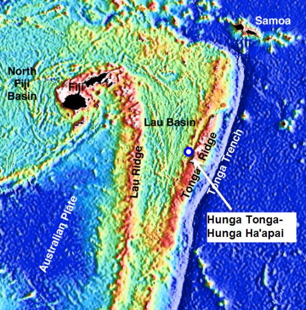
Locationof Hunga Tonga-Hunga Ha'apai volcano on Tonga arc (credit: http://www.science.psu.edu/alert/Images/r2k_laubathymetry.jpg)
The Pacific Plate is subducting westward underneath the Australian plate creating this oceanic volcanic arc (check out this slick visualization of the deep seismic data showing the subducting slab). Bathymetry data is absolutely critical for understanding oceanic arc systems becase the vast majority of the area of these prominent features is underwater.
Have a nice Sunday!
–
* I am glad I’m writing that and not attempting to pronounce it
~~~~~~~~~~~~~~~~~~~~~~~~~~~~~~~~~~~~~~~~~~~~~~~~~~
Friday Field Foto #79: Shazam!
When stratigraphers construct correlation diagrams of sedimentary rocks across many 10s to 100s of km the depiction of small-scale relationships has to be simplified. It’s impossible to show meter-scale detail on a diagram meant to depict regional relationships*.
For example, here is a correlation diagram for the siliciclastic depositional systems in Utah related to the Cretaceous Western Interior Seaway (from the Univ of South Carolina sequence strat website, a great resource).
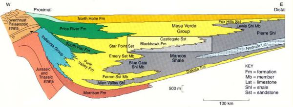
Credit: Univ of South Carolina Sequence Stratigraphy website -- Cretaceous lithostratigraphy showing the prograding shoreline facies of the Mesa Verde Group interfingering with the Mancos Shale (after Coe et al, 2003); http://strata.geol.sc.edu/index.html
Note how boundary between the yellow (Ferron Member, Emery Member, Blackhawk Fm, etc.) with the gray (Mancos Shale) is not a smooth line — it is drawn as a jagged line. Stratigraphers informally refer to these as ‘shazam’ lines and they are meant to represent facies changes among different rock types that are the same age.
But when you zoom in to the scale of an outcrop, the ‘shazams’ are typically larger than what you can see in any one spot.
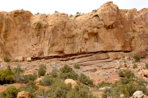
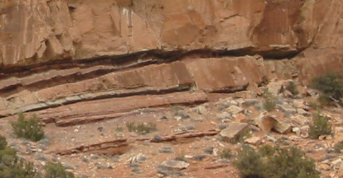
This week’s Friday Field Foto is an example of this type of relationship at the outcrop scale. The below photo is from Triassic (?) strata in Dinosaur National Monument in northeastern Utah (note: the below photo is not part of geology shown on diagram above, that was just an example).
The next image is zoomed in a bit more.
Note how the finer-grained layers (dark red is siltstone) are pinching out towards the right. Just below that, a sandstone bed is thinning to the left. So there you go — shazam! Over several kilometers most of this sandstone cliff is replaced by finer-grained strata by this style of small-scale interfingering of facies.
–
* That said, I can envision a visualization tool similar to the Gigapan viewer in which one can zoom in and out of a correlation diagram and observe multiple scales of relationships. That would be a fun and challenging diagram to construct.
~~~~~~~~~~~~~~~~~~~~~~~~~~~~~~~~~~~~~~~~~~~~~~~~~~
Papers I’m reading — March 2009
Here is my monthly list of papers I’m reading (or want to read) for March 2009.
- Somme, T.O., et al., in press, Relationships between morphological and sedimentological parameters in source-to-sink systems: a basis for predicting semi-quantitative characteristics in subsurface systems: Basin Research, 10.1111/j.1365-2117.2009.00397.x [link].
- Catuneanu, O., et al. (27 other authors!), 2009, Towards the standardization of sequence stratigraphy: Earth-Science Reviews, v. 92, p. 1-33 [link]. — Also see The Dynamic Earth’s post about this paper here.
- Wynn, R.B., et al., 2002, Characterization and recognition of deep-water channel-lobe transition zones: AAPG Bulletin, v. 86, p. 1441-1462. [link].
- Einsele, G., et al., 1996, The Himalaya-Bengal fan denudation-accumulation system during the past 20 Ma*: The Journal of Geology, v. 104, p. 163-184 [pdf].
- Zuhlsdorff, C., et al., 2008, Persistent quasi-periodic turbidite activity off Saharan Africa and its comparability to orbital and climate cyclicities: Geo-Marine Letters, v. 28, p. 87-95. [link].
–
* now that I look at that title … isn’t that supposed to “myr” in that usage?
Happy St. Patrick’s Day Rock (repost)
Yeah, I know … St. Paddy’s Day is more of an American holiday than an Irish one … blah blah blah, etc., and so on … whatever, it’s fun!!
Because I am really lazy busy I am going to re-post my green rock from last year’s St. Patrick’s Day.
This photo is from the Cambrian Bliss Sandstone in the Franklin Mountains of westernmost Texas. The greenish material is glauconite … an authigenic mineral that typically forms in marine shelf settings, thought to reflect very slow sedimentation rates. In this example, the glauconitic sandstone is actually reworked material (note the cross stratification).
To learn more about what glauconite actually is, how it precipitates in sedimentary rocks, and what it means, check out this paper from Chavez and Reid (2000; Sedimentary Geology, v. 136)
Happy St. Patrick’s Day!
~~~~~~~~~~~~~~~~~~~~~~~~~~~~~~~~~~~~~~~~~~~~~~~~~~
Sea-Floor Sunday #42: Faulted sea floor, Ionian Sea
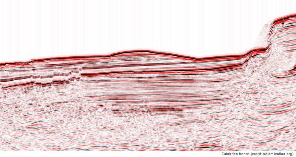
The majority of Sea-Floor Sunday images I show are maps of sea-floor topography (or bathymetry), so this week I am instead going to show a cross section image of the sea floor and shallow subsurface.
Last year I posted about the online seismic-reflection image collection website Virtual Seismic Atlas. They now have 410 individual images and are always getting more (in fact, if you have access to images that could be released to the public, they are always looking for data donors).
They have several fantastic images from a survey in the Ionian Sea (south of Italy). The first one below is about 25 km across (click on image to go to page on VSA).
The next image below zooms in a bit more to show the detail.
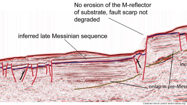
The image below is the same as above but with some annotation explaining the features.
And, zoomed in a bit.
The high-resolution images of both the interpreted and uninterpreted profiles can be found here.
What’s great about the Virtual Seismic Atlas site is that many of the images are of sufficient resolution and quality that they could be used for teaching (e.g., a tectonics and sedimentation class).
–
To learn more about the tectonic evolution of this area, check out this page from Columbia University’s Earth Institute.
~~~~~~~~~~~~~~~~~~~~~~~~~~~~~~~~~~~~~~~~~~~~~~~~~~
Friday Field Foto #78: Sampling volcanic ashes
As most of my readers already know, I recently returned from another trip to southern Chile to look at the Cretaceous sedimentary rocks exposed in the Patagonian Andes (my 6th year in a row). This year was different in that the primary purpose of the trip was to convene an SEPM field conference with my colleagues and show others in our field these great rocks.
But, since it is such a long way to go, we added a couple days before and after the conference to do a bit of field work. A student at my alma mater completed her final (?) field season down there this year. She is a structural geologist working on the evolution of the basin in relation to the fold-thrust belt.
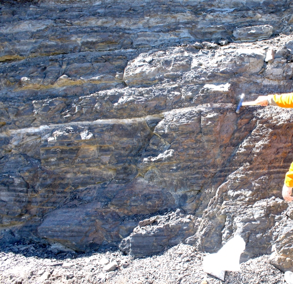
In the last couple of years an old road was improved significantly, which created numerous new roadcut outcrops. These new roadcuts reveal some incredible exposures of previously unexposed deep-marine sedimentary rocks. What the roadcuts also reveal are some volcanic ashes! In this week’s photo the prominent white stratum (also marked by hammer at right side) is one of these ashes.
This ash layer, along with several others, were sampled and their ages will be determined sometime this year as part of this student’s dissertation. This is very exciting because this basin needs some more age control badly.
~~~~~~~~~~~~~~~~~~~~~~~~~~~~~~~~~~~~~~~~~~~~~~~~~~
