Where on (Google)Earth? #90
January 12, 2008
JMA found BGC’s Scottish coast location for #89. Since JMA also does not have a blog, he emailed me a location and I’ll post it here for him.
For any new players to Where on (Google)Earth, simply put the lat-long or detailed description of the location in the comments below. A lot of us will typically say a little something about the geography or geology and sometimes we share our tactics for searching. If you win, you get to host the next one.
As usual, the Schott Rule is in effect (previous winners must wait one hour for every win that they have before offering a solution).
Good luck!
Post Time: January 12th, 2008, 10:05 AM Pacific Standard Time (convert to your time zone here)
~~~~~~~~~~~~~~~~~~~~~~~~~~~~~~~~~~~~~~~~~~~~~~~~~~~~~~~~~~~~~~
7 Comments
leave one →

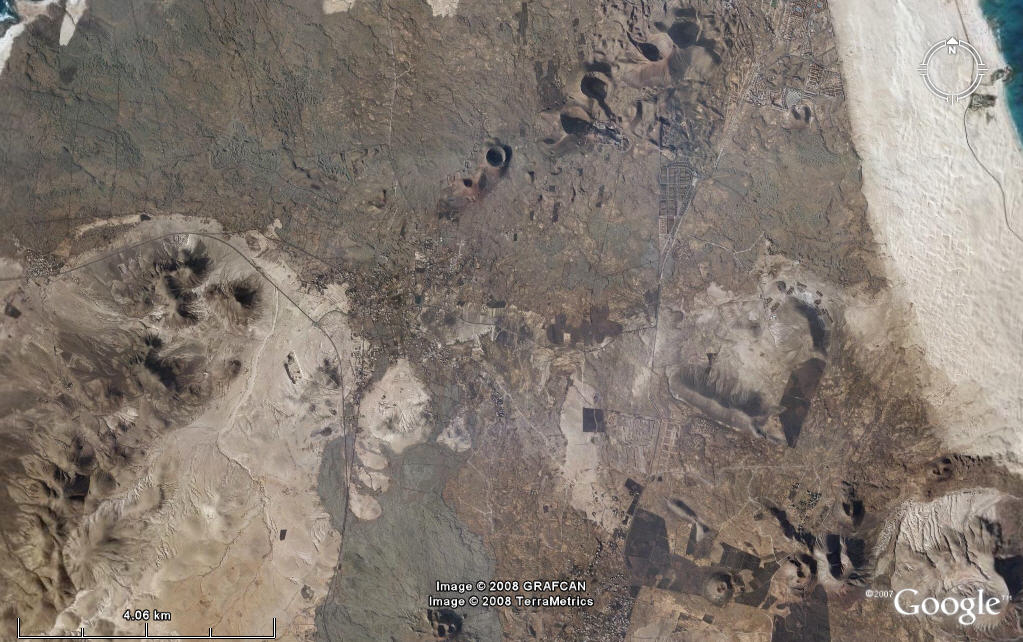
I saw them from above on my vacation to Lanzarote to the north if it many years ago. Those are cinder cones and maybe some lava flows in the northern part of the canary island of fuerteventura. Last volcanic activity was likely holocene. At least I don’t know of any historic eruptions. The canary islands are said to be resting above a hot spot that is fed by a mantel plume (though I heard there are people who disagree on that). Those dunes on the east side are suppossed to be a great beach area and in the west the bright area ia basicly desert. The island has a pretty dry and windy climate. Sometimes gets some airborn sand from the sahara.
Approximate coordinates:
28°41’9.30″N
13°54’18.65″W
How to find? Well, there aren’t that many textbook volcanic fields on the world. Island maybe, but it’s too green there. Then I remembered my vacation on Lanzarote (my shoes melted there from the hot soil).
Mathias … nice work, the next one is yours! You can either put one up right away, or you can wait a few days … up to you.
JMA … if you have any other info about this location (your pick), go ahead and put it in the comments …
Thanks!
I saw there is some kmz file with previous locations. Can you point me to it? I don’t want to ask for the same location by accident. Once I have it I will take a pick.
Mathias … Ron is the one who keeps updating the .kmz file … as far as I can tell, the one he links to in this post is the most up-to-date (linked to in the word “veterans”).
http://ron.outcrop.org/blog/?p=131
Ron … if you are reading this, can you post a link to the kmz here? And, now that we are on the subject, how do you link to a kmz…I know how to link to other pages, but not files like that.
WoGE master file (currently thru WoGE 82).
http://ron.outcrop.org/kml/WoGE.kmz
WoGE #91 – it’s up! Head over to http://lostgeologist.blogspot.com/ it’s the top post.
I can’t really add any comments because Mathias explained it so well. The dunes on the east are said to be be airborne sand from the Sahara but when I went there it had a very high proportion of shelly fragments.
I went exploring around the northernmost cone but it was being used as a rubbish dump. That that was in the late 90’s so hopefully it’s changed now. I understand that holiday development on Fuerteventura is now being limited.