Sea-Floor Sunday #2: Submarine landslide
Today’s bathymetric image is from Santa Barbara Basin, offshore southern California. Santa Barbara Basin has received a lot of mud (and very little sand) since the Last Glacial Maximum (~18,000 yrs ago), and therefore has a nice “smooth” look to it in the bathymetry. But, there is a prominent geomorphic feature that pops out. It is a submarine landslide scarp and deposit called the Goleta Slide. Click on the below image for a larger view.

Here’s a blurb from the Monterey Bay Aquarium Research Institution (MBARI) mapping program website:
The Goleta slide is a 134-km2 compound slump and debris flow off Coal Oil Point near Goleta. The slide is 14.6-km long, and is 10.5 km wide, extending from 90 m to nearly 574 m depth. The Goleta landslide is composed of distinct western, central and eastern segments, suggestive of multiple failure events. Each segment contains a well-defined head scarp, down-dropped head block and a slide debris lobe. The debris lobes exhibit hummocky topography in their central areas that appear to result from compression during down slope movement. The toes of the western and eastern lobes are well defined in the multibeam image, whereas the toe of the central lobe is less distinct and presumably older.
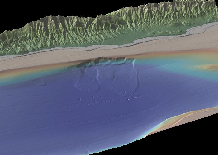
Below is another image…this one a perspective image looking north-northeast. The headwall scarps along the continental shelf edge are clearly visible. This one is also worth clicking on for a larger and higher-resolution view.
There have been numerous studies about Goleta slide…I don’t have time right now to go into them in detail. This link will take you to Google Scholar with “goleta slide” in the search box.
These images were produced with a freeware application called GeoMapApp from the Marine Geoscience Data System. Sometimes it’s a little bit clunky to use (not as slick as GoogleEarth), but is a good way to explore for high-res bathymetry data in a global database.
–
UPDATE: You may have found your way here through geology.com/news. Thanks to them for the link! If you want to see more sea-floor images, check these posts out.

There certainly have been multiple slides at Naples Point. If you walk the beach here you’ll find a 16 million year old slide in the Miocene age, Monterey shale. The slide is marked by a tectonic breccia at its base, within the Monterey shale. It is exactly up dip from the recent offshore slides! I mapped this slide in the 1950s when I mapped the geology of the Santa Barbara coast. It can be seen on both sides of a canyon that breaks through the sea cliffs at Naples Point. At the eastern outcrop, the blocky breccia rests on steeply dipping Monterey shale. Here, it looks like a recent slide or just a slump. At the western outcrop the blocky breccia is seen to be beneath the Monterey shale. It is a syn-sedimentary slide within the Monterey shale! Other geologists have mapped this as a channel, but there are no signs that the blocky chunks of Monterey shale have been moved along by water flow in a channel. This is a tectonic breccia at the base of a very old slide!
Eric Phillips, Geologist
Eric … wow, thanks for commenting! You must have some great stories to tell. The only outcrops I’ve looked at along the coast there are the Miocene rocks at Gaviota beach.
Your welcome Brian. We did have a lot of fun and excitment in the 1950s exploring for oil, particularly on the little drill ships we used in the Santa Barbara Channel. Our ship was the La Busca, a 136′ converted W.W.II minesweeper. We drilled over the port side with a significant list.
I was very lucky and was assigned to map the entire coast from Point Mugu to Point Conception. I went out only on low tide days and it took about 3 years. I also mapped portions of the Santa Maria coast and Santa Cruz (a month staying at the cattle ranch), Santa Rosa and San Miguel Islands in the S.B. Channel.
The “must see places” along the coast are the syn-sedimentary slides just around Point Mugu to the west, in the Topanga formation in the cliffs and the abundent fossils just over the cliff edge right at the point, the oil seeps at Carpenteria, the syn-sedimentary slides at Santa Barbara Point, but only at low tide, the gracefully curving strike of the Monterey shale in the tide pools near Gaviota Pass, again only at low tide and of course the interesting Miocene tectonic breccia and slide at Naples Point. You ought to get some pictures of thses two outcrops at Naples. Every geologist I’ve ever taken there, swears the easterly outcrop is a recent slump. I just say, “It looks old to me.” As we walk the 200 yards to the westerly outcrop we argue over what we’ve just seen. At the westerly outcrop, we have a good laugh.
Looking at the rocks at all these sites makes for great picnic days.
Eric Phillips, Geologist
How about one of you University of California, Santa Barbara, geology students taking a nice run up the beach to Naples Point and taking two pictures of the Miocene tectonic breccia that is evidence for the slide I described. Then get Brian to put the pictures on Clastis Detritus? I think that would be really interesting to a lot of people. Don’t make up your mind at the outcrop at the eastern side of the canyon that cuts the cliffs. I know you’ll think that’s a recent slide. Go to the western outcrop and you’ll see for sure it is a Miocene age slide. That would make a great post for Brian. And, thanks Brian for passing the recent posts on to me. Eric Phillips