Geologic Misconceptions: “Layer-cake” stratigraphy
This post is part of the fifth installment of the geoscience blog carnival, The Accretionary Wedge. The topic is ‘geologic misconceptions’ and it is also National Pie Day. Instead of pie, I discuss cake … a very messy, uneven cake. Head on over to Green Gabbro for info and links to all the posts for TAW #5.
~
I don’t care if the sedimentary layers in this image “look” flat…they’re not.
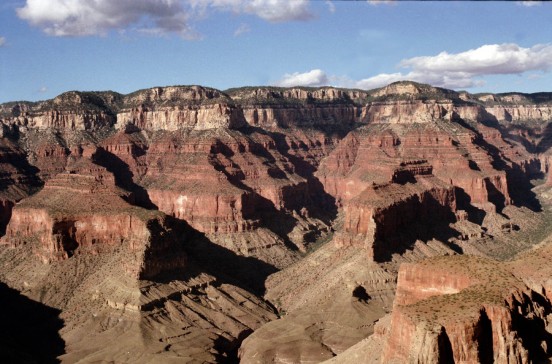
Okay … maybe they are essentially “flat” over a few or even several 10s to 100s of kilometers. But … as one who studies strata, one of my pet-peeves is the portrayal of sedimentary successions as perfectly flat layers.
It is more appropriate to think of sedimentary layers as sedimentary bodies. No sedimentary layer goes on forever … they eventually pinch out, get cut out, or gradually change into a different type of sedimentary rock. As a result, these bodies have a shape to them … they are not rectangles. Nearly all sedimentary bodies, when viewed in a 2-D cross section, are some sort of wedge-shaped body. Bailey (1998) called these bodies “lenticles”, that is, they have a lenticular shape. The geometry might not be visible unless you impose a great deal of vertical exaggeration (as stratigraphers often do with cross sections) but it is there nonetheless.
Why does this bother me? Or, to put it another way, why is this important?
The “layer-cake” view of stratigraphy bothers me because it does not appreciate (1) complex patterns of deposition/erosion or (2) complex patterns of preservation. A snapshot of a depositional system (i.e., some place where there is net accumulation of sediment) looks more like this:

credit: GoogleEarth
That’s the Lena Delta in Siberia from GoogleEarth … click on it for a nice, hi-res version.
In most cases, however, we do not see a fully-preserved delta in the rock record. The processes of long-term preservation creates a body of sediment/rock that is typically an amalgam of numerous elements of the system over a long period of time. These processes can, in some cases, “smooth” out some complexities but they also introduce some of their own.
Most geologists who don’t specialize in stratigraphy know what I’m talking about. If you do a lot of field geology and have done some mapping, you have, at one time or another, had to deal with units that have significant thickness changes or the study area. In other cases, you may have been able to treat the sedimentary layers as having essentially constant thickness across the mapped area (e.g., some epeiric sea carbonate rocks do indeed go on for 100s of km with little thickness change).
But, the point of bringing this up is not so much for geologists, but for everyone else. Of course, the term stratigraphy itself is rooted with the word for “layer”. I’m not going to get too nit-picky…that’s fine if we call them layers. But, the next time (and every time after that) that you are looking at a sedimentary “layer” remember that what you are looking at is actually a 3-D body with a complex shape and even more complex history.
–
UPDATE: check out the post by Hindered Settling about misconceptions that arise from 2-D vs. 3-D representations.
Trackbacks
- Accretionary Wedge #5: Geological Misconceptions and Pie
- The Accretionary Wedge #5: Geological Misconceptions and Pie « The Accretionary Wedge
- goodSchist.com » Blog Archive » The GeoBlogosphere Review #1
- Wooster Geologists » Blog Archive » Wooster’s Fossil of the Week: A bryozoan etching (Upper Ordovician of Indiana)

Maybe you just need to bake your cakes more crookedly.
I don’t know about you, but my layer cakes always come out crooked. And lumpy. And missing filling in some spots. (They always taste fine, but apparently I am incapable of assembling them properly.)
Back in the 70s my dad was a district ranger (interpretation) on the south rim of the canyon. We lived there for five years. He also taught a course called “The Geology of the Grand Canyon” through Yavapai Community College. I (when I was 12) took the course (I brought it up to the minimum necessary students). One of the biggest shocks for the students was on one of the field trips down to Phantom Ranch at the bottom of the Grand Canyon. Dad showed them the Grand Canyon series atop the Great Uncomformity. Some of the students just could not get their mind around sedimentary rocks at an angle. Another on which confused some of the students was the Temple Butte Limestone (wedged in between the Redwall Limestone and the Tonto Formation) which is thin, spotty and found in lenticular cells not more than 40 metres wide in the East end of the canyon, but the further west one goes, the thicker it is.
Good post. I enjoy your site. Even though I am an historian, the geology of my youth keeps rearing up and sending my mind in new directions.
Incidentally, if you find yourself in Northeastern Pennsylvania, there is a roadcut near Wilkes-Barre, PA (Route 309, Cross-Valley Expressway) which shows shale lenticles about 10 to 15 metres across and up to 1 to 1.5 metres thick.
Lab Lemming and Tuff Cookie … perhaps we should someday have a cake/pie creating contest … whoever makes the most creative geologically-inspired baked good wins!
Billy … thanks for the nice words. I hate to admit it, but I’ve never been down to the bottom of the Grand Canyon. I’ve only been there once and that was only at the rim for a family reunion. It’s still on my list.
Brian R.: It’s worth doing. Back in the 70s, my dad did a lot of work with the geological maps to produce a color-coded version. If memory serves, the most interesting area (geologically speaking) is the east end where the Colorado is running North-South before taking the right turn through the Coconino and Kaibab plateaus. I think (and again, its been a while so I could be wrong) that the Grand Canyon Group shows up a lot on the North side of the canyon (geographic west). The outcroppings near Phantom Ranch are fairly small.
I haven’t been back there since 1988 (sister’s funeral) and haven’t been into the canyon since 1978. One of the absolute best ways to see the geology (if you’re not a hiker) is by raft or dory. The fluted schist (man, that sounds dirty, doesn’t it) in places in the inner gorge are incredible. And don’t worry. The side hikes up the canyons get hou to plenty of sedimentary outcrops.
Great post. I work on sedimentary architecture on various scales, so this is right up my alley. Excellent idea for a misconception.
Years ago I did some quadrangle mapping along the Flint River, just north of Lake Blackshear, on the Georgia Coastal Plain, for the Georgia Geologic Survey.
On a nearby tributary, Turkey Creek, in an asymmetrical valley, one could sit on a bluff composed of Middle Eocene Lisbon Fm., Late Eocene Clinchfield Fm., and a cap of Miocene Altamaha Fm. (fluvial deposits). Across the creek, Quaternary alluvium of the modern floodplain overlay the Miocene Altamaha Fm. at the same elevation of the Middle Eocene Lisbon at the base of the bluff. In other words, you couldn’t correlate from one side of Turkey Creek to the other.
Five miles to the southeast, a well log recorded 60 feet of Late Eocene limestone above the Clinchfield Fm., totally missing from the Turkey Creek bluffs.
A mile and one half to the west, along the Flint River (east bank), the Miocene Altamaha overlay the lower Middle Eocene Congaree/Tallahatta (the Lisbon and Clinchfield were missing).
My boss didn’t believe me and hired one of the elder statesmen of Georgia geology, Tom Crawford, to field check my work. After a couple of days in the field, Tom agreed with me that the geology was screwed up. He suggested a couple of minor map changes just to mollify the boss and to just leave the rest to someone else to straighten out, as the mapping project schedule didn’t permit a detailed study of the area. He was able to explain the situation to the boss.
Previous workers had suggested some sort of subsurface structures in the area, but had not attributed any surface oddities to the structures (maybe they just ignored them). There is a thesis/dissertation project awaiting someone there.
Hi, I’m part of a team of translators (English-Spanish)working in a proyect related to terms included in the field of geology. We are very interested in the information we have seen in your blog and would like to know how to contact you and if we may forward some questions.
Thank you very much
Barnaby
Barnaby … go to the “About” page and you’ll find my contact info.
por buscar mi postre favorito..!!strata..!!muy interesante..!!