Sea-Floor Sunday #3: Gulf of Mexico continental slope
This blog has moved to Wired Science (as of Sept 14, 2010)
URL: http://www.wired.com/wiredscience/clasticdetritus/
RSS: http://www.wired.com/wiredscience/category/clastic-detritus/feed
–
The continental slope in the northern Gulf of Mexico has a very distinct appearance. Note the pock-marked nature in the water depths colored red in this bathymetric image below. The coastal area at the northern end of the image is the Mississippi delta of Louisiana.
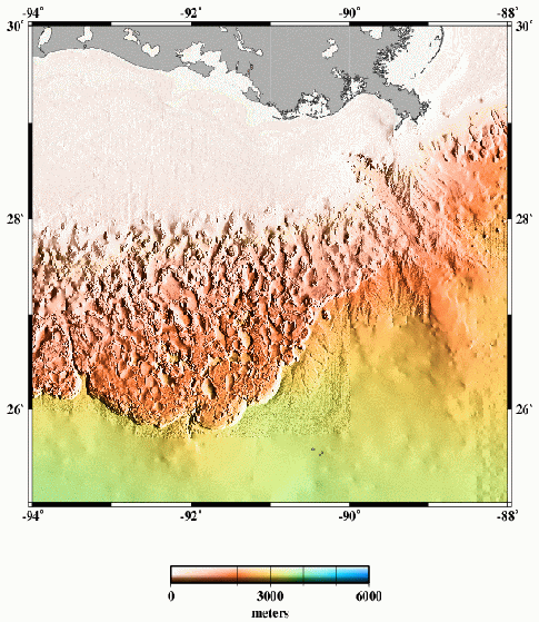
The transition from the pock-marked slope to the smoother and lower-gradient abyssal plain (yellowish colors in image above) is a rather abrupt escarpment with nearly 1,000 m of relief.
Here’s another image of the GoM continental slope from a great Geology paper from over 10 years ago now by Pratson and Haxby (link to paper here). This is a perspective view looking towards the east. The black area in the upper left is the continental shelf.
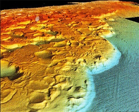
The escarpment I pointed out above is clearly visible in this perspective image. Note the arcuate shape of the trend of this escarpment (called the Sigsbee Escarpment). If it reminds you of a thrust-front, that’s because it is!
The morphology of the GoM continental slope is dominated by salt tectonics. Jurassic evaporites have evacuated causing some areas to sink (the pocks, or “mini-basins”). That evacuation is balanced by salt diapirsm in other areas. Overall, the entire slope is affected by gravity and slowly moving towards the deeper part of the basin. The Sigsbee escarpment is the compressional front of that large-scale movement. In detail, each mini-basin is extraordinarily complex showing fascinating relationships between turbidite sedimentation and salt movement. A feedback is set up such that turbidites are deposited in the lowest parts (that’s what they do), which causes more underlying salt to evacuate, which in turn makes the basin subside, which maintains that spot being the lowest. Some mini-basins have 20,000 feet of Quaternary sediment in them!
There’s tons of information out there regarding the Gulf of Mexico. If you’re interested in more, you won’t have much trouble finding cool stuff.
–
Check out this page (a professor at Colorado School of Mines) for more about salt tectonics, in general.
Top image from here.
See all Sea-Floor Sunday posts here.
~~~~~~~~~~~~~~~~~~~~~~~~~~~~~~~~~~~~~~~~~~~~~~~~~~~~~~~~~~~~~

So which bits have oil in them?
it’s everywhere…sort of
most of the hydrocarbons that are in sediments above the salt have been discovered, and are being produced
the big unknown now is how much is hosted sub-salt … the big issue is that the salt wreaks havoc on seismic imageing … you just can’t see anything below that stuff, it’s all fuzzy
so, there are some very expensive holes ($100 million a shot!) being drilled just to find out … some of these wells are over 30,000 ft deep
Man, if somebody gave *me* a 100 million dollar drilling budget…
“Man, if somebody gave *me* a 100 million dollar drilling budget…”
They’d expect you to find something worth $100,000,000.01
How can I find imagry of the bottom in a certain area. I am a fisherman in Mississippi. If I could find bathymetric imagery or multi beam mapping of a certain area it would help tremendously. Any type of bottom mapping would really help. If anyone would know how to get this information please let me know.
Steven,
As far as I know, there’s no one place to find all sea-floor maps for a certain area. Most of the data I find is from various places. One good source is this NOAA site: http://www.ngdc.noaa.gov/mgg/coastal/coastal.html
But this is pretty regional in resolution … I’d imagine for a fisherman you’d want very high-resolution images. That would take a lot more hunting around for the most appropriate. I will keep my eye open and post about it if I find something.
Is it not true that depressurizing the continental shelves through oil and gas extraction will accelerate coastal subsidence as landward strata slump into the evacuated pockets that held the oil and gas?
Google “North Sea floor subsidence” and you will note that the sea flor capping Norway’s Trol and Ekofisk oil fields has subsided a remarkable 25 feet!
Jim
Jim … that is a great question. I think you’re right that oil/gas production can influence subsidence. But, to what extent and how that differs case by case, I don’t know off the top of my head. I’d hate to speculate too much w/out looking into it some more. Something for a future blog post for sure. If any other readers know some good refs/links please put them here.
I notice that you discussed drilling for oil under salt formations. Just recently, a large sinkhole in Texas was blamed on the undermining and collapse of a salt dome.
Jim
Drilling in deeper and deeper water on the continental shelves means drilling closer and closer to the inflection point where the relatively gradual slope of the shelves plunges much more steeply to the oceanic abyss. In other words, the undisturbed strata that buttress the coastlines are getting thinner and thinner.
This can only lead to disaster. Should shelf subsidence cause the loose alluvial burden on the shelves to start to slide, what engineering marvel could prevent this moving silt from plunging into the abyss and generating a tsunami? Note that both sides of the Florida Strait, narrow and steep, are being actively considered for oil and gas extraction.
I(a layman) agree that each case is different, but subsidence in general due to mineral/fluid extraction is already so commonplace that alarm bells should be ringing loudly and clearly. Instead we get this fatuous “Drill, baby, drill!” political sloganeering, and the subsidence issue seems totally ignored in the rush to oil riches. Again, this can only lead to disaster.
Jim
Jim says: “Drilling in deeper and deeper water on the continental shelves means drilling closer and closer to the inflection point where the relatively gradual slope of the shelves plunges much more steeply to the oceanic abyss.”
There has been ‘deepwater’ (i.e., beyond the continental shelf edge) drilling activity in offshore regions of the Gulf of Mexico (GoM), Niger Delta, and Zaire/Congo canyon already (for the past 15 years give or take). There are certainly much fewer as compared to the shelf. And, at least in the GoM, there are numerous production platforms somewhat close to the continental shelf edge.
Jim says: “Should shelf subsidence cause the loose alluvial burden on the shelves to start to slide, what engineering marvel could prevent this moving silt from plunging into the abyss and generating a tsunami?”
So, do you mean that the entire shelfal area will ’tilt’ seaward causing sediment gravity flows? Are you envisioning a regional, larger-scale phenomenon or at smaller scales? I guess I’m having a bit of difficulty understanding what you are saying here.
In terms of generating a tsunami, the key ingredient is significant and rapid vertical displacement of the water column. The 2004 tsunami was caused by a thrust fault (subduction zone fault) that ruptured and vertically displaced the water column. Another potential hazard, which is more closely related to the process you are describing, would be a landslide event. Failure of volcanic edifices (e.g., Canary Islands) into the ocean can create this displacement of water. The effect of submarine landslides w/r/t tsunami generation is not very well known.
I’m not saying we shouldn’t be concerned, or even worried, about drilling-induced subsidence, but we need to carefully clarify exactly what the hazards are, where they are, how to mitigate them, and so on.
I see the problem of subsidence, whether gradual or sudden, as a fairly widespread phenomenon. The shape of our main Gulf oil field south of Louisiana, long(east-west)and thin, indicates that a fairly contiguous volume of the sea floor is essentially being hollowed out.
Lots of oil/gas sites are similar to the mouth of the Mississippi. The mouth of the Rhine is a major gas producer, the Niger as you said, the mouth of the Congo, the mouth of the Volga, the mouth of the Tigris-Euphrates, etc. All with loose semi-fluid alluvial deposits. Whatever the risk of subsidence-induced tsunamis, this situation is so commonplace the risk cannot be small.
Thanks for your helpfulness and courtesy
Jim
I don’t know of any particular examples of this kind of subsidence, do you? If the risk was more than minimal, surely there would be examples?
As discussed in Insurance Journal:
Subsidence — Some areas of the Gulf of Mexico floor have experience several feet of subsidence, or settling, related to production.
Usually, significant settling is found in older platforms because it can take 20 years to obtain 8 to 12 feet of subsidence. For example a platform installed in 250 feet of water 35 years ago may have been installed with a deck height of 45 feet. But after 20 years of production from multiple wells, there may be 10 feet of subsidence that reduces deck height to, say, 35 feet — leaving the platform more vulnerable to wave-in-deck loads never considered in the original design.
A further problem is that ground water, generally closer to the surface than deposits of oil and gas, migrates into the evacuated pockets that held the oil and gas. In essence, countries like Saudi Arabia are trading water availability for oil, not necessarily a good deal.
Jim
Jim … just an FYI (see today’s post), I’m disabling commenting for about a week while I travel. I’ve been getting a lot of spam lately … if you comment, it won’t be lost, but it won’t show up until I approve it next week.
DOI: 10.1306/5D25C0CB-16C1-11D7-8645000102C1865D
Progress of Exploration in North Sea
P. E. Kent (2)
AAPG Bulletin
Volume 51 (1967)
After an account of the occurrences of oil and gas in the countries adjoining the North Sea the paper outlines the regional structural features of northwestern Europe. The outcrop geology of the North Sea floor is described and followed by an account of the stratigraphic succession in the Tertiary, Cretaceous, Jurassic, Triassic, and Permian formations. Geophysical surveys have included gravity and magnetic surveys which define the main basins, and seismic work which has shown that salt structures ranging from non-piercing salt pillows to steep-sided diapirs are developed through most of the southern North Sea. Drilling has led to discovery of three gas fields of commercial size in the basal Permian sandstone up to the time of compilation of this paper. One additional dis overy since has been made in the…”
Note the commonalities of the various oil/gas regions.
Jim
The Storegga Slide: A Major Challenge on the Northeast Atlantic Margin
Espen Sletten Andersen1, Anders Solheim2, Petter Bryn1, Carl Fredrik Forsberg3, Kjell Berg4, and Tore Kvalstad3
1 Norsk Hydro ASA, Oslo, Norway
2 International Centre for Geohazards, Oslo, Norway
3 Norwegian Geotechnical Institute, Oslo, Norway
4 Pertra AS, Trondheim, Norway
The Ormen Lange gas field, which is the second largest gas field offshore Norway, was discovered in 1997. The field is located in water depths of 850 to 1100 m, in the central scar left after the Storegga Slide. This submarine slide occurred about 8200 years ago and is one of the greatest submarine slides ever recorded. Run-out is nearly 800km into the Norwegian Sea, and the volume of mobilized sediments is roughly 3000 km3. The affected area is 90 000km2, equivalent to nearly 30% of the Norwegian mainland, and the slide caused a devastating tsunami. The Storegga Slide is only the last in a series of huge slides in the same region during the last 0.5-1.0 My.
Extensive multidisciplinary geohazard studies have been carried out since the discovery of the field, including morphology, geophysics, regional and local geology, geotechnical borings, slope stability assessments, numerical modelling, gas hydrate studies, etc. The studies have revealed a close relationship between the variable glacial – interglacial depositional regimes and large-scale sliding. Long periods of contouritic, fine-grained deposition in an interglacial to interstadial regime, are interrupted by short periods of intense, rapid glacial deposition during peak glaciation. This caused excess pore pressure to build up in the buried deposits, reducing stability. The slide was triggered on the mid-lower slope and developed retrogressively.
The studies were performed in a fruitful cooperation between industry and academia, and showed that such an integrated, multidisciplinary approach was the key to success. Despite challenging morphological and geotechnical conditions, the Ormen Lange area is considered safe with regards to new large slides. The Norwegian Parliament approved development of the Ormen Lange gas field in 2004. This presentation emphasises on the slide morphology, the deposits and the geohazard aspects of the region.
I’m just a layman, but this kind of thing doesn’t seem very safe to me, and it’s going on all over the world.
Jim
The Ormen Lange gas field is described as centered under the massive Storegga slide, described as one of the greatest submarine landslides ever.
Note that North Texas has been experiencing what was described as “unusual” seismic activity in the last couple of months. This seems to include the Barnett shale formation, where large-scale gas extraction has just begun.
Too many common factors among mineral extraction, subsidence and seismic activity to be realisticly written off as coincidence.
Point made?
Jim
Jim … are you claiming that Storegga slide was triggered by drilling activities?
No. I’m suggesting that the centrality of the large gas field to the slide area implies the possibility that the slide was caused by a major “burp” of the gas field , which then destabilized the alluvial deposits and caused them to move suddenly.
As I say, I’m just a layman; would such a “burp” necessarily leave specific evidence of its occurrance?
Jim
I see … well, if gas was leaking to the surface (either slowly or catastrophically) at some point in the past (at least as old as 8,200 yrs per age of slide) then there probably wouldn’t be a gas field left at all. That is, the trap and seal would’ve been compromised. But, I don’t know anything about the details of that area or those fields, so I can’t say for sure.
In terms of evidence for an ancient “burp” … that’s tough because the effects it has on what can get preserved (i.e., the sediments) is secondary and thus subjective.
But, again, I’m no expert on slope stability issues. Some quick googling found a couple docs that might interest you or at least lead you down a path to finding relevant references:
Slope Stability and Land Slides in the Deep Sea:
Influence Parameter Gas Hydrates
Click to access GrupeKiel2002.pdf
A simple model for submarine slope stability analysis
with gas hydrates
Click to access 60713_NGT_no_3_06_17.pdf
These are both specific to gas hydrates but have information regarding the parameters considered by geoengineers when evaluating/mitigating slope stability in areas where gas could be a hazard.
The first reference you provided begins with the following comment:
“Decomposition of gas hydrates is thought to be a major cause for the instability of submarine slopes and deep sea floor….”
Apparently this concept has been knocked aroound since at least 1982.
Long-term oil seeps are of course commonplace in places like southern California and offshore G-O-M. Mexico’s supergiant offshore field, Cantarell, was discovered when a fisherman kept complaining to authorities about oil (which turned out to be from seeps) fouling his nets and the Mexican government finally investigated. In the novel “Oil”, about southern Cal’s oil industry, Bunny and his father hit the mother load when they notice an oil seep and decide to take a chance. Even in this instance, the author noted a coincidence between oil deposits and earthquakes.
Jim
Jim says: “Even in this instance, the author noted a coincidence between oil deposits and earthquakes.”
I’m not sure what you mean here … that the occurrence of petroleum is near faults? Or that the timing of earthquakes is related to the extraction? There is plenty of data to investigate this relationship.
Jim, I’m happy to keep discussing this but, to be honest, I’m a bit unclear of what you are trying to say. I apologize if I don’t understand. I need you to refer to more specifics, more hard data.
Where I’m going ultimately with all this(which I’ve been doing since 1978)is to argue that offshore oil extraction should be phased out because of the threat of catastrophic subsidence, in favor of the shale oil deposits of Utah, Wyoming, and Colorado.
The smallest estimate of the amount of shale oil in the deposits is 400 billion barrels. With our present oil consumption at 22 million barrels per day, 400 billion barrels theoretically provides 25 million bpd for forty years, enough to provide a bridge fuel to a presumably more technically advanced future, and incidentally to crush OPEC.
Given that this so completely dwarfs the several tens of billions of barrels potential of offshore extraction, offshore drilling might as well be phased out, the subsidence threat avoided, and investment capital put to other uses.
Oil shale has important advantages. The deposits are within a 2000-mile radius of Des Moines, Omaha, St. Lois and Chicago to the East, and Las Vegas, Phoenix, and Southern Cal to the West. Because the shale lies athwart the Continental Divide, the shale is uphill from most of its markets.
The oil would require some pumping , but when you’re moving millions of tons of product, the ability to do it mostly with, rather than against the force of gravity, is significant.
There are certainly coincidences between oil deposits and faults and actual seismic activity. Canterell is situated in a web of great cracks in the Earth’s crust left by the asteroid that hit Yucatan 60 million years ago. Tangshan, site of a devastating quake in 1976, is on the rim of what was China’s largest active offshore field.
Significant oil fields in Sumatra are in proximity to the fault that caused the great Indian Ocean tsunami. Baluchistan, newly productive of natural gas, suffered a major quake, while the adjacent Iranian hinterland north of the Persian Gulf, has suffered many quakes as well. Sakhalin is another example of this dualistic phenomenon, and of course Southern Cal.
The public(speaking as a layman) understands tectonics in generalities; that is, a great continental plate butts against another great continental plate. In reality, where the plates meet are continental “crumbs”, bits of crust that are minimal in geological terms, but vast multi-county areas in human terms. All these “crumbs” are pressed together like the stones in an arch and hold each other in place.
Oil extraction is now getting well below 20,000 feet, and some of this is near faults. This is getting to be at the depth from which shallow earthquakes spring. It is easy to imagine extraction and consequent slumping activating a fault and causing one of the crumbs to shift, activating the other crumbs in response.
Makes sense to me.
Jim
Jim, while it may make sense … our understanding needs to be founded in data. I’m not saying the data doesn’t exist, I haven’t explored this topic … perhaps you can list some specific books/articles that discuss these topics?
An example of this subsidence/slumping effect is the new fault that appeared accross the “neck” of the Mississippi Delta south of New Orleans and northward of the Delta’s southernmost point.
This is consistent with what I have been saying. While the fault is now opening very slowly, there is no telling if the spreading will accelerate, and if extraction becomes widespread in even deeper water, spread acceleration would be expected.
Note that this slumping effect need not become apparent very quickly. The new Mississippi Delta fault only appeared after decades of offshore extraction–thousands of square miles south of the delta being undermined, and many more to come.
Jim
Just thought I’d throw this in, recognizing the need to demonstrate an alternative to offshore oil.
Neither party seem to get it economically. We are facing an annual shortfall of a trillion or a trillion-and-a-half dollars in investment capital to meet the renovation needs of our infrastructure, our manufacturing sector, our armed forces, and our health and education systems. This is about ten percent of our present GDP, and can only be accomplished in a low-tax, pro-growth environment.
How? Specifically, do first that which can reach fruition first. Concentrate on that which has the most beneficial secondary effects. Concentrate on that which can achieve a broad national concensus. A few examples:
1. A program of national housing renovations would put tens of thousands of tradespeople back to work, put a prop under sliding real estate values, and would begin to save energy from the moment the first broken window were fixed.
2. The “gross-effect battery” uses bulk waste products, such as acidic mine seepage, manure holding ponds, windrows of spoiled fruit, and garbage leachate as bulk electrolytes in crude but very large batteries. These bulk waste products are commonplace in society, and their electrochemical potential might as well be used as the waste would exist anyway, while the gross-effect battery can be designed to produce fresh water as a by-product.
3. Piezoelectric cells generate electricity when the cells suffer mechanical distortion. Many natural processes generate vast quantities of mechanical energy which is now wasted but available to be tapped: earthquakes, volcanoes, geysers, windstorms, avalanches, and many other examples abound. The calving of icebergs from glaciers involves the movement of million of tons of frozen fresh water, which movement could be translated into electricity while the water could be preserved from salt contamination.
4. Abrogate housing codes that demand high-maintenance landscaping and do not allow clothes to be dried on outdoor lines. “No blood for oil!” makes for a snappy slogan, but it does not answer the question of where the fuel for our economy will come from.
5. The smallest estimate of oil in Rocky Mountain shale is 400 billion barrels. This is enough to provide 25 million barrels per day for the next 40 years and to crush OPEC(our present oil consumption is 22 million BPD).
6. Incorporate regenerative shock absorbers into cars, along with regenerative brakes.
7. Develop urban agriculture, and incorporate community gardening into school curricula.
This would take millions of truck ton-miles off our overstressed highways and reduce pollution and wasteful congestion.
8. Emphasize the exploitation of “inner space”–the sea floor and upper atmosphere–over “outer space”. This would vastly accelerate returns on investment(I have a patent regarding bathysphere exploration).
I have no wish to understate the problems facing our country, but clearly there is no reason we cannot overcome them. “Do first that which can reach fruition first.”
Jim says: “An example of this subsidence/slumping effect is the new fault that appeared accross the “neck” of the Mississippi Delta…”
Is this your observation? I need a reference … where’s the data?
ect
Subsidence and Fault Activation Related to Fluid Energy Production, Gulf Coast Basin Project
Subsidence Related to Fluid Energy Production Home
Introduction:
Project Overview
Investigators
Research Objectives:
Production Parameters
Reservoir Parameters
Framework
Ground Characterization
Geophysical Methods
Land Loss
Publications
Project Contact:
Bob Morton
Related Link:
» USGS Energy Resource Program
Introduction
Image showing possible effects of petroleum production.
Figure 1. Possible effects of petroleum production. Prolonged or rapid production of oil, gas, and formation water (2) causes subsurface formation pressures to decline (3). The lowered pressures (3) increase the effective stress of the overburden (4), which causes compaction of the reservoir rocks and may cause formerly active faults (1) to be reactivated (5). Either compaction of the strata or downward displacement along faults can cause land-surface subsidence (6). Where subsidence and fault reactivation occur in wetland areas, the wetlands typically are submerged and changed to open water (7). Figure is not to scale. D, down; U, up.
The Gulf Coast Basin is a region where subsidence and fault activation are common around large, mature oil and gas fields even though moderately deep hydrocarbon production has generally been disregarded as the primary cause.
This project will test the hypothesis that long-term, large-volume oil and gas production in the Gulf Coast Basin has resulted in land-surface subsidence and activation of deep-seated faults around some fields. The project will:
* Investigate the magnitudes of environmental impacts;
* Estimate rates of deformation;
* Identify reservoir parameters that are indicators of subsidence potential; and
* Evaluate geophysical methods for regional subsidence detection and monitoring.
Other tasks will be to:
* Investigate the mechanisms and timing of subsidence;
* Determine if the processes are still active;
* Examine the environmental changes such as reductions in land elevations and elimination or replacement of plant communities;
* Develop conceptual and empirical models to predict subsidence impacts on the basis of production histories and regional geologic framework.
The results of these investigations will provide a basis for designing marsh and barrier-island restoration projects, planning hurricane levees, and managing oil and gas production.
thanks … looks like this link, right?
http://coastal.er.usgs.gov/gc-subsidence/
$2,835,823
Our Goal: $6 million
Donate Now »
[Expand]
Support Wikipedia: a non-profit project
Donate Now »
[Expand]
Support Wikipedia: a non-profit project — Donate Now
Michoud fault
From Wikipedia, the free encyclopedia
Jump to: navigation, search
The Michoud fault is a geological fault line that runs through eastern New Orleans. [1] The Michoud fault is the subject of extensive scientific inquiry into why Louisiana is losing vast tracts of land. [2]
Subsurface mapping identified the Michoud fault, on the basis of well cutoffs and seismic surveys. [3] Sedimentary growth implies that movement along the Michoud fault has been intermittent since Oligocene time (Bebout and Gutierrez, 1983). A cross section in McBride (1998) shows a high-angle normal fault that was correlated by Dokka (2006) with the Michoud fault. This fault merges with a low-angle detachment fault at –7 km deep that developed along the top of a slightly south-dipping zone of weak salt and shale. These structures are considered to be related to a regional south-vergent extensional-contractional complex described by Peel et al. (1995; Fig. 1). Movement of the complex and thus on the Michaud fault reflects gravitational instabilities and down-dip motion during times of high sedimentation (Peel et al., 1995).
The Michoud fault belongs to a class of geologic structures known as growth faults (Mauduit, T., Brun, J. P. 1998). Growth faults are common geologic structures of regions undergoing high sedimentation rates, such as river deltas and passive margins. They often develop where weak rock layers (detachments) such as salt, anhydrite, or shale underlie regions of rapid sedimentation. These weak zones allow the growing mass of material above them to slide downhill, either continuously or episodically. These downslope movements will be correspondingly experienced in the headwall region (such as that occupied by the Michoud fault) either as slow (barely perceptible) or rapid (catastrophic) subsidence. Growth faults are also sometimes called “listric faults”, implying that the fault is a concave-upward surface that transforms nearly vertical displacements at the surface into nearly horizontal ones at depth.
The Michaud fault is not unexpected or unusual as a geologic feature of the Mississippi Delta. Holocene faulting and tilting is widely recognized in many world deltas, such as the Nile, the Ganges-Brahmaputra, the Yangtze, the Po River, and the Rhine.[4]
[edit] References
* Bebout, D.G., and Gutiérrez, D.R., 1983, Regional cross sections, Louisiana Gulf Coast: Baton Rouge, Louisiana Geological Survey Folio Series 6, 10 p.
* Dokka R.K., 2006. Modern-day tectonic subsidence in coastal Louisiana. Geology vol. 34, p. 281-284.[1]
* Hickey, M., and Sabate, R., eds.,1972, Tectonic map of Gulf coast region, U.S.A.: Tulsa, Oklahoma, Gulf Coast Association of Geological Societies and American Association of Petroleum Geologists, Scale 1:1,000,000
* Peel, F.J., Travis, C.J., and Hossack, J.R., 1995, Genetic structural provinces and salt tectonics of the Cenozoic offshore U.S. Gulf of Mexico: A preliminary analysis, in Jackson, M.P.A., et al., eds., Salt tectonics: A global perspective: American Association of Petroleum Geologists Memoir 65, p. 153–175.
* Törnqvist, T.E., Bick, S.J., van der Borg, K., and de Jong, A.F.M., 2006. How stable is the Mississippi Delta? Geology vol. 34, p. 697-700.[2]
* Mauduit, T., Brun, J. P. 1998. Growth fault/rollover systems: Birth, growth, and decay. J. Geophys. Res. Vol. 103 , No. B8 , p. 18,119-18,136.
[edit] References
1. ^ Geologic Faults Cause Structures In New Orleans to Sink, Study Says
2. ^ http://www.cbsnews.com/stories/2006/03/31/tech/main1459939.shtml
3. ^ (Hickey and Sabate, 1972)
4. ^ (Törnqvist et al., 2006)
[edit] External links
* Fault Motion Animation
* Tectonic control of subsidence and southward displacement of southeast Louisiana with respect to stable North America
* Baton Rouge – Denham Springs Fault System, Lake Pontchartrain
Retrieved from “http://en.wikipedia.org/wiki/Michoud_fault”
Categories: Structural geology | Geographic areas of seismological interest | Seismic faults
Jim, you don’t need to copy/paste in everything from a page … just the link (if available) or the full citation of a paper (authors, year, title, journal/book/website, etc.) is fine.
I’ve been posting fuller accounts because it makes it more convenient for the discussion, as well as for interested 3rd parties who may pop in from time to time, to have the relevant material right on the thread, rather than having to re-access info every time. Does this impinge too much on your computer’s memory?
Thanks again for your patience and a most informative(from my point of view)blog.
Jim
Ref. FORBES, 11/24/08, p 73
This article discusses Shell’s Perdido field in the G-O-M, some 200 miles offshore and in water at least 7,500 feet deep.
This is at least 50 miles beyond the present major oil extraction zone, which runs in a narrow east-west crescent south of the Miss. Delta, and(according to the article) at least 4,000 feet deeper than what was considered “deep” water just a few years ago.
In other words, there is a strong gravitational gradient between the present main production zones and the proposed new zone. Likewise, the article describes the Perdido field as being situated accross “multiple fault lines”–in other words, the “continental crumbs” I have posited. Extraction and resultant pressure diminuation seem very unwise.
Perdido is exhibit A in my Pantheon of Ghastly Conclusions, but it is hardly the only one. The above recent posts specificly cite the Nile Delta as suffering the same kind of stress faulting as the area from New Orleans southward, and likewise having gas deposits in its hinterlands(offshore Gaza and elsewhere). There can only be a similar result–subsidence, and salinization of delta farms, a catastrophe for Egypt–while the continental shelf offshore Gaza is narrow and steep, an invitation to catastrophic subsidence, especially as the hinterland of Gaza includes the active Arava Fault on which the Dead Sea(many new sinkholes)lies.
As I said, there are so many similarities–oil and gas deposits offshore of highly-sedimenting rivers, large fields discovered near areas subject to stress faulting The whole Gulf of Mexico coastline from Cuba around to Florida, Alabama, Louisiana, Texas, Mexico, Maracaibo, and eastward offshore and to the Orinoco Delta–an enormous connected crescent hundreds of miles long crossing numerous faults. It is impossible not to conclude that the great oil bonanza and the subsidence it induces will end with a tremendous thud somewhere.
Jim
New York Times, Dec. 2,, 2008, page D 3
An article in today’s Science Times regarding iceberg formation provides an analogy to the seaward creep of land masses and acceleration due to submarine subsidence:
“…Scientists studying the potential impact of climate change need to be able to simulate how ice sheets and shelves behave, including how fast icebergs form. But no one has been able to formulate a basic rule for calving.
“Now Richard B. Alley of Pennsylvania State University and colleagues have come up with one. The rate of calving, they report in Science, is primarily a function of the rate at which an ice shelf spreads.
“This rather simple rule was devised after long study of data from ice shelves, including the largest in the world, the Ross Ice Shelf in Antarctica. They found that faster-spreading shelves have a higher rate of calving, while shelves that spread more slowly DUE TO BUTTRESSING FROM THE SIDES OR THE SEA FLOOR(my emphasis)produce icebergs at a lower rate…”
Disregard the fact that the ice fragments will float and the strata fragments will sink due to their greater density. It is clear that ice creep, and by implication the seaward creep of strata, is moderated by the buttressing effect of the regional continental shelf. Given that sea floor subsidence due to oil extraction(which we agree is commonplace)can only diminish this buttressing effect, it seems reasonable to conclude that offshore extraction can only accelerate this creep, whether we are talking ice or somewhat plastic strata. This is especially true where an enormous alluvial weight is deposited annually, enough to cause stress fractures, as at the mouths of major river systems like the Mississippi.
That seals it.
Jim
Brian–I would like to talk about my bathysphere patent, because I would love to get some feedback from the professionals here, some of whom are active in undersea exploration. As I have a commercial interest in it, I thought it best to get your permission first.
Jim
Jim … I’m a bit confused why you need any permission from me for anything. I’m just a guy with a blog. Feel free to elaborate here or you can e-mail (see the ‘About’ page) if you want.
Brian–many site managers object to members discussing their commercial interests, for fear of people getting conned.
At any rate, this is a summary of my patent, #6,438,957, “Piezoelectric Power Generating Arrangement Activated By Elements Caused To Rotate By Natural Energy Source”. I am a great believer in the future of undersea exploration; the patent describes what is essentially a cargo bathysphere functioning as a funicular car between a floating base on the ocean’s surface and bases at various depths and especially the bottom. The mechanical energy of the bathysphere’s descent and ascent is converted into electrical energy and compressed hydrogen and oxygen which are delivered to the undersea colonies along with the standard cargo.
The bathysphere empty is positively buoyant, it will float unloaded. As desired, the compressed hydrogen and oxygen could be used to affect the buoyancy.
The bathysphere has lateral hatches to facilitate loading/unloading. It also has a vertical hatch at the top for the initial loading at the surface. The bathysphere is intended to moor under a floating supply base or between the hulls of a catamaran supply ship. Initially, the, top hatch of the bathysphere is flush with the deck of the supply base or catamaran.
The bathysphere is held in place by piezoelectric latches. Thus, as the craft is loaded, the weight of the cargo will increasingly stress the latches and cause them to emit an electrical charge, which in turn could be stored in batteries or as pressurized hydrogen and oxygen electrolyzed from the ambient sea water.
When the bathysphere is released to begin its descent, the latches are immediately de-stressed, again causing the piezoelectric cells to emit a charge comparable to the entire weight of the craft and cargo, which charge can be further stored or utilized. The craft is piezoelectric-coupled to a cable between the floating base and the subsurface base; thus it rides the cable down.
The hull of the bathysphere is mounted with diaphragm-like tubes. The flexible head of the diaphragm is connected internally to a toothed rack which meshes with a gear on a shaft.
As the craft descends, increasing water water pressure forces the flexible head of the diaphragm inward and thus drives the toothed rack against the gear, thus turning the shaft and producing either AC or DC electricity as desired. The descent may be stopped at any desired depth, causing the piezoelectric coupling to emit an electrical charge proportional to 1/2mass X velocity squared, both at stop and restart.
At the bottom, the bathysphere is engaged by piezoelectric latches, again producing electricity proportional to 1/2 massX velocity squared, which in a descent of miles could be very large.
As the craft is unloaded, it becomes increasingly buoyant, again stressing the piezoelectric latches. The craft is then re-loaded for the trip to the surface, allowing for the innate buoyancy to lift the craft back. It seems likely the trip down will carry heavy equipment for expanding the undersea colony while the trip up will carry small, high-value objects suchh as geological and biological samples and refined gold or gems.
As the bathysphere rose, the decreasing water pressure would draw out the head of the diaphragm, causing the toothed rack to again turn the shaft, but in the other direction, producing AC/DC.Thus a highly profitable long term energy exchange , producing surplus electricity and pressurized gases in both descent and ascent, would be established.
Comments?
Jim
Jim … sounds interesting … but, I have absolutely zero technical expertise in this and really can’t offer anything of value. Sorry. You might see what the guys at the blog Deep Sea News think (http://blogs.discovery.com/deep_sea_news/) — they have way more knowledge about deep-sea equipment and exploration than I do. Good luck with your endeavor.
I came across this blog while looking for a deepwater Gulf bathymetry digital elevation model.
Subsidence above producing oil and gas fields does happen. One does not have to go to the North Sea. It has been documented in quite a few producing fields in the Gulf of Mexico region, but it tends to be very localized. In other words, producing oil from the sedimentary rocks of the Gulf will not cause the ENTIRE shelf margin to subside or collapse.
For instance, Caillou Island field located in the coastal waters off Louisiana used to be partially above sea level, but now it is submerged. But not all fields will show this. Many reservoirs produce with a strong water drive, which means that formation water from below displaces the oil and gas as they are produced, and there is no drop in reservoir pressure. I would not expect subsidence above such a field. Other reservoirs produce with a depletion drive, which usually happens if the reservoir is an isolated pocket with no connection to an aquifer. Such reservoir will show a drop in pressure with time as production goes on. Whether the pressure drop will cause subsidence of the overburden will depend on the depth of the reservoir, its thickness etc. Also, keep in mind that oil and gas are not contained is some caves in the ground, but in pores of sandstones and limestones. It depends very much on the strength of the rock matrix whether the rock will compact or not when the pore pressure changes.
4D seismic images of reservoirs in deepwater Gulf, which have been producing for 10-20 years, sometimes show evidence of compaction within the reservoir itself and in the overburden above it. I have recently done some 4D seismic work in the Gulf and have seen this. However, if there was compaction, it was always confined to the immediate area above the reservoir, and was not seen extending all the way to the surface (seafloor, in this case).
On a broader note, coastline erosion in Louisiana is a reality, but it has nothing to do with oil and gas production. Several reasons have been discussed, but the most likely one from a sedimentological standpoint is the lack of annual flooding. (See work by LSU and Bill Galloway at UT Austin). Before the Mississippi was confined by man-made levees, it would overflow the banks every Spring and bring silt, sand and mud onto the floodplain. This annual replenishment of fresh sediment is needed to maintain the coastline. Once it is shut off, tidal and wave erosion takes over and the coastline retreats.
Radman … thanks much for sharing your expertise. This thread died down a while ago, but I’m glad you took the time to add this information to it.
I am not very geologically ept? but I have worked in the oil field both on and offshore subtantially. On land, once fields become depleted, we often inject water down wells to raise the level of oils to their original levels allowing them to flow slightly. I realize water and oil have different densities but quite often if not always are produced together in some form or another. Couldnt this be utilized to stem the processes you discuss here? While working in the field, I have often thought removing something under or around plates has to destabilze things. I personally am all for going green but we need time to transition.
I am interested into whats going on but im having a little bit of trouble understanding this whole deal. What are they drilling for in the ocean?
I am hoping that many who are familiar with the type of details included in this blog, are brainstorming as to how the oil gusher on the continental shelf – resulting from the recent oil platform disaster – can be stopped … I am really concerned that this whole disaster might be only the beginning of a catastrophic one – if that gusher is not stopped soon …
I am afraid that it is nonsense. A well blowout has nothing to do with coastline erosion.
In response to coastal erosion in Louisiana, is not the land subsidence also caused by oxidation of the highly organic muck soil after being drained via canals. In the similar muck soils on the south side of Lake Okeechobee, Florida, there has been documented cases of the soil level subsiding +4 feet after the area was drained and the soils exposed.
Jim. I have a simple question for you if you can indulge me.
If there is subsidence overe the area being extracted, would’nt that mean that there is a possibility that the wells could suffer damage if there is an instance located at the well point?
Is’nt this a possible source of leakage.
Thanks Stephanie R
memphissigncompany.com
Stephanie:
Saw your post. I am an oil and gas exploration geologist, so here is my 3 cents:
The BP well that blew up was an exploration well, which means that was no production yet from that prospect. That means there could not have been any localized subsidence of teh seafloor that could be attributed to the compaction of the reservoir.
I don’t work the Gulf anymore; I moved to SE Asia several years ago, but I do follow the domestic industry. The well was being drilled in Mississippi Canyon Block 252 and the prospect name is Macondo. Most likely, the reason for the explosion was an underground blowout in the reservoir when they hit it, they could not control the pressure, the gas escaping from the reservoir up the wellbore and onto the drilling floor caugh fire and exploded. The drilling rig sank, most likely not as the result of the fire, but as the result of massive amounts of gas filling the water around it. The rig could not float, sank, the riser that conencts the rig to the wellhead on the seafloor broke, and now you have 5000 barrels oil per day freely flowing into the ocean. This has nothing to do with subsidence.
Personally, I cannot imagine how something like this can happen, given the huge amount of work that goes into pressure-profile prediction before drilling starts. That’s between BP and Transocean to find out.
I miss Jim and his lunatic rants.
I don’t think Jim’s posts were “lunatic rants” … He may even be on to something … and he seems to be quite skilled at researching and presenting information …
: – )
Thanks Radman,
If the rig sank due to lack of bouyancy due to nitrogen/gas bubbles. Should’nt it have risen back to the surface at least partially due to water tight compartments after leaving the bubble formation area? It’s obvious that the ruptured pipes were due to the collapse, but it seems as if there was another reason that is unknown. What about the possibility that there was a blow out at the point of drilling due to weakening of the surrounding strata. Is it possible that they are able to determine pressures of the oil reserve in some soft of way prior to drilling?
I’m not an oil guy so sorry if my questions are a little out there.
Stephanie R
Memphissigncompany.com
Hi Stephanie:
It actually not nitrogen that is escaping from the seafloor; it natural gas (which is mainly methane) and sometimes CO2.
What sank the drilling rig is a speculation at this point until Transocean (the drilling contractor) has a chance to look at it. But, the two principal reasons could have been: too massive amounts of gas in the water or fire damage. We had an explosion on a production platform last year that caused a fire that lasted a week. It was hot enough to partially melt steel!
I don’t know exactly how the rig was constructed. But, when it sank it filled with water and when it hit the seafloor it probably sustained more damage and probably woudl not float again. I am not an egineer.
Prior to drilling any exploration well, we do a pressure prediction for the entire drilling profile (not just for the target reservoir) based on seismic velocities. I am a geophysicist, so this is part of what I do. The drilling engineers need to know what to expect, where to set casing (= how much pipe to order of what diameter), etc. However, seismic velocities are not exact and surprises do happen. That is why every drilling rig has BOP stack (= Blow Out Preventers) to shut the well in if an underground blowout happens. Why the BOP stack did not work in this case is the big question. Who knows. The government and the fishermen will be suing BP who operated the well, BP will be suing Transocean who operated the rig, Transocean will be suing Cameron who built the BOP stack, and Cameron will be suing the contractor who did the cement job on the well…. :) This is job security for lawyers on all sides for years. They will be raking in billable time and damages by the truck load.
Now that you explained it, I guess it is’nt a mystery…except for the blowout protector.
I read that there were two of them and neighther one worked properly. If this is the case, how many others are out there waiting to not work when there is a problem.
If there was a gas bubble event, would’nt that be visible from a satellite photo? It should appear differently than the water and oil, and also should cause motion patterns in the oil that would differ from the wave action on the reflection of the wave induced spread.
I don’t think the steel melted, I think some waterproof doors were open and the massive amounts of water flooded the structure, then some bulkheads ruptured due to pressure.
All I can see in my mind is this huge hole with a pipe sticking out of it on the ocean floor gushing oil. The hole is getting bigger as more and more material is blown away. Scarey is’nt it?
Stephanie R
Memphissigncompany.com
Hi Stephanie:
Again, I have to stress that I am not a driller. But I did talk to our chief drilling engineer about what explanations are circulating around the drilling community. There are some explanations for what could have caused the blowout preventer to malfunction and they are all related to the way the well was being completed: the casing design used. A human factor, in other words. What happened, he described it as the “worst case scenario” any deepwater operator has ever considered.
BP and Transocean have obviously both closed ranks and no official explanation has been given, or will be given for a long time, because it means huge liabilities. You won’t hear anything for months or years from them.
As for a hole in the seafloor, I don’t think there is any. The oil is simply leaking from the ruptured riser pipe that was broken when the rig sank.
Yes, the gas in the water may be visible on satellite imagery, but when it is, it is too late. It all happened in probably a matter of minutes, or perhaps tens of minutes from the time the underground blowout happened.
Further on this, I have to correct one of my earlier statements regardring the type of well this was and pressure prediction while drilling. The well BP was drilling in Mississippi Canyon Block 252 was not a wildcat exploration well. The prospect had been drilled and discovered prior to this well and, based what I was told, this was an appraisal well to confirm the size of the reserves. It had finished drilling, it was completed and was in the process of being suspended for later use as a production well. The typical drilling succession when a new field is discovered is: exploration discovery well –> appraisal wells –> production wells.
So, the drillling engineers had a pretty good idea about what the pressure profile was ahead of teh drill bit. The blowout happened AFTER all drilling was finished and the well completion was underway. Again, I am not an engineer, but this seems to be a well completion screwup, not an unexpected drilling problem.
What this means for slope stability, coastline subsidence along the gulf ? Absolutely nothing.
Radman … thanks for adding your perspective here. There’s a more current post about this event over at the blog Highly Allochthonous: http://scienceblogs.com/highlyallochthonous/2010/05/drilling_for_oil_is_more_risky.php
That thread might benefit from your comments here.
Radman,
now I think I understand more about what you were saying. So in a layperson’s lingo, there is a pipe sticking out of the ocean floor with a device ( valve ) that is’nt working, and the pipe is broken further up the pipe and spouting oil. Also there is not soil blowing out like a geyser.
Ok this is conforting, but if they are going to place these big concrete and steel boxes over the pipe using mass/weight to seal the leak and then pump it or let it flow again to the ships, what happens if the pipe is much longer and the box won’t fit. Thwy would just cut the pipe off yes as oil should’nt burn without oxygen?
As far as the operators maintaining silence, this is to be expected to limit liability. Usually when I see a picture of oil wells there is a large discharge pipe of burning gas of some soft. This must be the natural gas from the oil pocket yes? Is this what you said caused the fire on the oil rig? “Deathstar Horizon”? Ha ha little joke.. So this could have happened at any time after a breach in to the pocket.
What do you think they will try to do to plug the leak? I read about some other project to inject cement with another drill hole. Does’nt that have to be rather accurate? It seams as if concrete is heavier than crude oil and would just sink to the lowest part of the oil pocket.
Is that just wishful thinking with 5000 feet between a bouncing drill rig and one small point on the ocean floor? Oh by the way can they aim those drills like that?
Thanks
Stephanie R
memphissigncompany.com
Hi Stephanie:
No, there is no geyser of sediment being expelled from the seafloor. That is how Hollywood would have portrayed it. :)
So far Transocean and BP have tried to shut off the Blowout Preventer valves manuallt with a ROV sub. That did not work. The next option is to place a containment dome over the wellhead on the seafloor and contain the flow. The oil has to go somewhere because the weight of the dome alone will not contain it. Keep in mind that a reservoir like this one can have 10,000 PSI pressure in it. The oil would just find some other way out. It would have to be somehow send to the surface and stored in a floating storage vesel. It will not have to be pumped at all. If it is coming ot of the ground at 10,000 PSI, they have the opposite problem – how to keep it contained!
As a side note, very few oil fields in the world have to be pumped. Those pictures of suction-rod pumps on CNN when they want to show an “oil field” are actually quite rare. Again that is just Hollywood. Most reservoirs flow on their own. What is on the surface is a wellhead (called a “Christmas Tree” because of all the valves sticking out of it in every direction), maybe a storage tank, and a flow line transporting the reservoir fluids somewhere else for treatment. Only very shallow oil reservoirs with low pressure need pumping. Gas always flows on its own.
OK, next:
Gas flaring is sometimes done on a drilling rig (land or offshore) if natural gas is coming up with the drilling mud from the formations being drilled through. The gas has to be burned for safety reasons and that is the flare you would see. The driilng rig does not have storage for it, nor is there a pipeline nearby to send it to. Flaring would typically not be done on a production platform because (a) burning the natural gas means burning money and (b) there are environmental concerns and, depending on the country, struct regulations whether gas can be flared or not. I.e. in Nigeria, it is the government’s gas.
Finally, more on the containment issue:
They already tried to shut the blowout preventer valves manually but that failed because it had apparently been damaged. The next step is this containment dome. A few drilling people I spoke with do not think it will work.
The third option that has already started is drillling a relief well. That involvees positioning another drilling rig nearby, say 1/2 mile, spud a new well, drill vertically to about 5000 below the seafloor and set surface casing. Make sure everyting is cemented in place properly, then use directional downhole motors to steer the wellbore toward the wellbore that has the problem. The goal is to intercept the old wellbore above the zone where the blowout occured. The original well was 18,000 deep from sealevel. With 5,000 of water, that means the blowowwut occured somewhere like 12,000 feet below the seafloor. They need to find and hit the old wellbore somewhere just above that depth.
Directional drilling involves a downhole motor that is steered from the surface and powered by the pressure of the drilling mud circulating in the wellbore. I can give a drilling engineer a drilling target the size of a room, located 10,000-15,000 deep, and they can design a well to hit that target. The smaller the target, the more expensive the operation, generally. However, hitting a target the size of a room is not good enough it you are looing to hit a steel pipe 9 inches across and mill a hole into it.
We had to do this last year on a well that blew out. What I saw was this: conventional directional drilling technology was used to get the bit close to the original wellbore, and then some sort of magnetic sensors were used to help locate the other wellbore. The well has a steel casing pipe in it, so it is seen as a magnetic anomaly. The bit is pulled back and steered again, pulled back and steered again. When they touch the old wellbore, then pull the bit out of the new wellbore, replace it with some sort of a mill, go back down and mill a hole into the wellbore of the other well. Obviously, they need to be prepared to handle the pressure kick from other well, so that they do not end up like the Deepwater Horizon! :) Then, you would have two leaks! Once they manage that, they start pumping massive amounts of very heavy drilling mud or maybe cement into the problem well. Whatever they pump in will be carried up the wellbore, not down. Remember, 5000 barrels/day are flowing through there at a pressure that coudl be 10,000 PSI. The hope is that eventually the stuff will harden and shut off the flow of oil. Then, they can move in with ROVs to the old wellhead, cut off the broken riser, repair the old wellhead and permanently plug the well.
How much does all this cost? The operation of a deepwater drilling rig or a drillship is about $1,000,000/day. A typical deepwater well in the Gulf can cost $50,000,000-$100,000,000 to drill. If it is a development well, another few hundred million to complete (= get it ready for production). In this case, they probably need 3 months do the job.
The slightly dangerous part here is that the relief well had to be planned in something like 1 week. Normally, it takes 6-12 months to properly plan a deepwater well. Eventhough they know the rocks in the area, do you think they must have taken a few shortcuts?
Correction:
A typical deepwater well in the Gulf can cost $50,000,000-$100,000,000 to drill. If it is a development well, another few tens of millions to complete.
Hello again Radman,
I was reading that the “BOX” they were going to place over the ocean floor was freezing up and clogged the exit pipe. Now they want to install a smaller one. Won’t that do the same thing? I also read theyw ere thinking of cutting the pipe and installing a larger pipe and the fear was that it could let more oil out and maybe impossible to close up. What happens if they can’t stop this leak? it seems like they could make a huge concrete box that weighs 50 tons or something like that and just set it on top of the leak using mass/weight to seal the edges on the floor.
Also what is this “Mud” they are talking about and how is this mixed with concrete to seal up the leak?
On a separate subject I read about this mud volcano in Indonesia that has been pumping out mud for like 6 months or so. They wanted to drop concrete blocks in to it to help “Clog” it up. Pretty interesting stuff.
Stephanie R
memphissigncompany.com
Hi Stephanie:
I don’t know what a smaller containment dome would do… whether it would work. I will be in a meeting with a bunch of deepwater drilling guys on Friday and I can ask them….
They will stop the leak, but it may take time. Ultimately, the one solution that will work is drilling the relief well. The bad thing about that is that it will take time. Possibly several months because a deepwater well designed to 18,000 feet subsea can easily take 3 months to drill from the date they spud it.
“Drilling mud” is a technical term for the fluid that is pumped into the wellbore from the drilling rig, through the drill pipe. It comes out the bit and returns to the surface where it is filtered, and pumped back in. Its function is to (a) wash away the cuttings created by the bit as it is drilling through rock formations, (b) lubricate the wellbore and keep it in good shape (c) carefully maintain pressure balance between the wellbore and formations. The mud composition is a science in itself and no two wells will have drilling mud exactly the same. There is a mud contractor on the rig with their own engineers whose job it is to control the mud. Compositions vary depending on the type of formation being drilled, so that the mud does not dissolve it or the formation does not cave into the wellbore. Composition also vary depending on the formation pressure the wellbore is encountering. The idea is to continuously regulate its density, so that the hydrostatic pressure in the wellbore equals the pressure in the rock formations the wellbore is drilling through. If the mud is mixed too light, the hydrostatic pressure in the wellbore will not be enough to keep formation fluids from entering it and you can get a pressure kick or, in the worst place, an underground blowout. If the mud is too heavy, it will be leaking from the wellbore into the formation and lost, which costs money and drains supplies.
So, in this case, they plan to pump some type of dense mud and/or fast-hardening cement into the relief well, pump it into the damaged wellbore, where it will be carried up by the pressure of the oil and gas escaping from the reservoir. The idea is that the mud and cement will have 10,000-12,000 feet to travel up to the seafloor, which will give them enough time to eventually harden and plug the damaged wellbore.
I haven’t heard about the mud volcano here in Indonesia. But that is a different kind of mud. “Mud volcanoes” are common in oil and gas producing basins, where natural gas is escaping from the ground is large quantities. Simply gas vents on the seafloor. In this case, the “mud” refers simply to dirt on the seafloor :)
8 June, 2010
All:
I was on a “Mississippi mud boat” called the Bayou Chico when it was outfitted with the first satellite navigation system (NNSS) in Brisbane, Australia, courtesy of the US Navy. We shot lines in the Arafura Sea, Solomon Sea, and ran a highly illegal boot-leg survey across the Great Barrier Reef. This was in 1969 and our navigational precision was limited to the continental shelf, since the Doppler sonar was unreliable at depths greater than 100 fathoms.
So, I am curious about the system that located the deep water oil that relegated me to the operator of a museum piece!
I have experienced the “send money, lawyers and guns” clout of the oil industry, in terms of gaining access to profitable oil fields around the world. I know how risky offshore oil exploration is even when “due diligence” is performed.
What baffles me is how such an expensive effort to harvest what seems to be the greatest gusher of all time (10,000 psi and millions of gallons of crude/day) could be sabotaged by skimping on the “due diligence” part of the operation?
Were all the controls and safety systems, including the blow-out preventer, tested at regular intervals? Were the crews fully trained and signed off to operate the various equipment on the rig? Were safety drills performed? Why couldn’t the blow-out preventer be manually over-ridden? Most importantly, where was the oversight by the Prime contractor? If I invest $500 megabucks in a project, I want to know that my subcontractors are doing their jobs per spec!
Evidently, the short-term profits gained from taking short-cuts regarding performance has cost BP $1.2 gigabucks, and that figure is climbing.
Following this thread, I recall that this well configuration is the penultimate to the production well system, and that the pressures and other characteristics of this particular find were becoming understood, in terms of how to handle the output. I would like to know how the (10,000 psi and millions of gallons of crude/day) metric compares to the spectrum of other finds. It seems to me that this phenomenon is more like an eruption than a gusher a la the classic Texas oil shower we see in the movies.
Finally, thank you all for this valuable insight to this incredible mess. The public needs to hear about the how and why of the blowout, along with the best remedies. What they are hearing is mostly propaganda from all sides. [I was told that this would never have happened if the Democrats had allowed drilling on the continental shelf.]
Perhaps we all can calm down long enough to do damage control. Point fingers later.
I was wondering if the rapid displacement of the oil and the forming gas bubble could actually cause a displacement of the sea floor in the Gulf. and…if that were possible, couldn’t it trigger a tsunami?
Would love a comment from you – thanks.
Cia: No. On a scale of the Earth’s crust, a reservoir flowing several thousand barrels of oil is nothing. Remember that the reservoir from which the oil is flowing is some 12000 ft below seafloor. For a tsunami to form, you need rapid up-and-down movement of the seafloor. A flowing well can hardly cause this.
Also, remember that the reservoir may not experience any pressure decrease even though oil is flowing out of it. Many reservoirs produce with strong water drive, which means formation water from structurally lower portions of the reservoir (= the acquifer) displaces the oil at the top of the reservoir and it is being produced, and the reservoir pressure is maintained. Many people think there is a big void down there somewhere from which oil and gas are pumped out like a tank a gas station. That ain’t the case :)
UNEASYRIDER :
As you know, seismic imaging is used to find subsurface reservoirs that may contain oil and gas. Back in the 60s, it was 2D, now it is 2D, 3D and 4D. Whether the imaging is done on land or offshore, GPS is used to record the coordinates of the seismic source for each shotpoint as well as receivers. This is easier on land. Offshore, if the recording streamer cable is very long (20,000 feet in some cases if you need to see below things like salt), it can experience feathering due to currents, but the end of the streamer is recorded as well. I am not a seismic acquisition specialist, but know a bit about it. Does this help?
10,000 PSI reservoir pressure is normal in the Gulf of Mexico, even more. Some of my wells I proposed onshore in Louisiana had more reservoir pressure. One thing I am not so sure about are these speculations about 30,000 – 40,000 – 80,000 barrels per day flowing out of the damaged wellhead. I have never seen a Gulf of Mexico reservoir produce this much. Even if the oil is flowing through the annulus of the well (not through the much narrower tubing pipe), and even though there is no choke on the wellhead, this would be an unheard-of production record. Sad, it’s flowing into the water and not into a tank :(
I’d like to hear your story about shooting a seismic line across the Great Barrier Reef :) That was before HSE was involved in everything :)
Radman
RELIEF WELL
The permanent solution to the BP spill is the drillingof 2 relief wells, designed to intercept the damaged wellbore at a depth of approx. 10,000 ft below seafloor, mill a hole into the casing pipe, and then pump cement and heavy mud into it. Once they are connected into the old wellbore, it will be plugged permanently within a few days.
There is a interesting graphic in teh last issue of Time that shows the 2 wells BP is drilling. I am surprised they are not talking about them. Instead, everybody is haggling about useless containment domes, top kills, junk shots etc.
Here is a picture from a similar situation alst year in Australia:

I really miss Jim!
Radman has the expertise; but Stephanie has given him a workout! I just posted the discussion page on FB, as our InvestiGatorZ team has been engaged in back engineering this for some time on our radioBlogs at BTR (BlogTalkRadio).
Some intro: I have a background in corrections/zooKeeping convicted felons. I now use radioblogging to connect with the exPERTS with the questioners in LIVE open line forums.
You will find our discussions on Facebook and other blog sites; most of our energies are being devoted to educate the blogging community on a subject that very few were writing about in April of this year. Who would have thought this would be the hottest discussion in North America in an Election year??
I was the tech support for EnergyExpertsLIVE on BTR in 2008; we had wonderful guests and hosts discussions on Energy Policy and my own scant background in drilling, exploration and workover of completion wells in Kern County, led me to question the exPERTS that I met in the field…for about 3 years.
So keep asking the experts Stephanie, and yall can join us on FB to follow the industry to its glorious turnaround; i.e., clean it up or swim in the Gulf with the dead fishies…memo to all of the above corporations.
Radman, I value your exPERTise. Really. I hope that we can have you call in to one our networks to debate with those of US who prefer talking to typing. Blogs turn viral, and so the discussions will OUTlast and OUTperform the industries that are sinking along with that rig in the Methane Gulf.
One last thought…Follow the Euros. Why have ALL the regulatory agencies rallied to protect the Polluters? Look at the Board of Directors for ALL the contract companies…the BP execs who sold Stock in their own company before the disaster? The Rise of NALCO, with a former executive of Monsanto? If anyone with prior knowledge of an accident can PROFIT from said accident, what is the inCENTive to avoid accidents?
Stephanie, you are on the right TRACK…ask the expert why anyone would dump a billion gallons of water on an oil and gas fire; on a floating platform, worth a billion dollars and ready for the junk heap, according to the mandated decommissioning time of offshore platforms?
I will save a few more questions for next time, if we have the Grace of God to continue…some of MY questions about offshore were sent to me in 2008 by a high school student in New Jersey who wanted to interview me as an exPERT! LOL :))
http://RenegadeLawyerBlog.com is not mine, but is following our FB posts.
Jim was right! This was really dangerous. It’s still leaking.