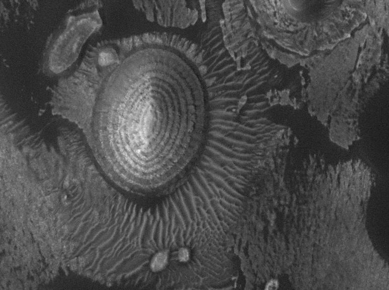
Mars Global Surveyor…R.I.P. (1996-2006)
 © 2006 by Malin Space Science Systems, Inc.
NASA lost contact with the Mars Global Surveyor (MGS) nearly a month ago. It appears it is now lost. MGS had a good run…orbiting the red planet taking high-res photos of the surface. It contributed to the success of the Rover mission by helping find landing spots.
The above photo shows flat-lying sedimentary rocks eroding into an oval-shaped hill that has linear sand dunes around it.
Check out the online database of MGS images.
~~~~~~~~~~~~~~~~~~~~~~~~~~~~~~~~~~~~~~~~~~~~~~~~~~~~~~
The view from Berkeley
 I snapped these on Thanksgiving evening. They are taken from the Berkeley hills looking west across the bay toward San Francisco. In the picture above San Francisco is a little right of center…you can bareley see the silhouettes of the buildings. The Golden Gate bridge is against the far right of the photo. Note crescent moon.
The picture below is zoomed in on the Golden Gate bridge. Alcatraz is in the foreground and you can see the Farallon Islands way in the background.
Click on images to see a high-res version.
Yes, it’s expensive to live here…but, sometimes you get what you pay for.

~~~~~~~~~~~~~~~~~~~~~~~~~~~~~~~~~~~~~~~~~~~~~~~~~~~~~~~~
RealClimate.org
 RealClimate is a blog-style website put together by several scientists who are actively study the Earth’s climate system. If you’re already a science geek then you can keep up with the latest misleading or just plain wrong information spewed out by editorialists. These guys are good at untangling the sometimes confusing or seemingly contradictory information that is given to the general public. Because it is a blog, there is a chance to reply to the topic and get a discussion going. A lot of the people that participate in this are also climate scientists…so you get a chance to “listen” in on the discussions they are having.
If you are new to the types of data thrown around and how the climate system works, in general, then check out the index page first. There’s a lot of good info in there.
~~~~~~~~~~~~~~~~~~~~~~~~~~~~~~~~~~~~~~~~~~~~~~~~~~~~~~~
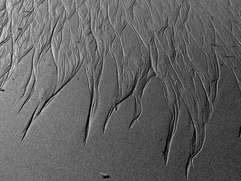
Friday Field Foto #4: Patterns in the beach
 A day late …
Here’s a photo I took this October while walking on a beach up near Eureka, CA. These little erosional rills formed in this one area of the beach. You can see how the sand was re-sedimented into some neat patterns just a few feet downhill (towards the top). The width of the frame is about 3 or 4 feet across.
Giant storm on Saturn
 nasa.gov
This hurricane-like storm is 5,000 miles across (about 2/3 the size of Earth) with estimated winds of 350 mph. Click here to read more about it. Also note in the blue and red images above…all those spots are smaller storms within the big one!
~~~~~~~~~~~~~~~~~~~~~~~~~~~~~~~~~~~~~~~~~~~~~~~~~~~~~~~~~
Tsunami in ancient Lake Tahoe
 This recent article in the San Francisco Chronicle discusses some geologic research that indicates there was a massive underwater landslide in the ancestral Lake Tahoe sometime between 8,000 and 15,000 years ago. This slide, possibly triggered by an earthquake, created a tsunami that, if it happened today, would flood the low-lying populated areas.
Keep this in mind if you’re planning a ski vacation to Tahoe!
Friday Field Foto #3: Big Sur coring cruise
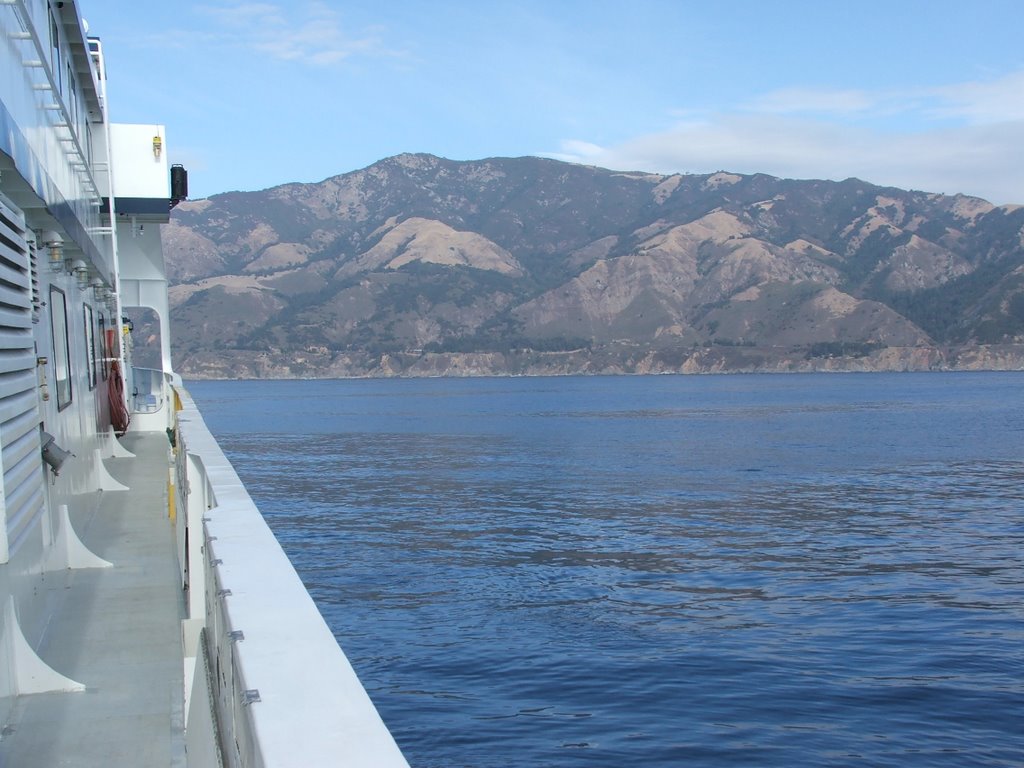 This week I had an opportunity to go out on a research cruise with the Monterey Bay Aquarium Research Institute (MBARI) to do some deep-sea exploration of submarine canyons offshore of the Big Sur coast south of Monterey.
This is different field work than I’m used to. I’ve mostly been studying ancient deep-sea sediments (now exposed in mountains) whereas this trip was looking at modern deep-sea sediments.
They drop an ROV attached to a cable from a ship. This ROV can fly around just above the sea floor, has a robotic arm to grab stuff, and a bunch of cameras for observation. The analogy one of the guys on the boat made was — imagine exploring the Grand Canyon by dropping a video camera in a Volkswagen beetle from a helicopter on a cable over a kilometer in length, during a moonless foggy night.
The image above was our view of the Big Sur coastline (you can even see Highway 1 if you look hard enough) while we were sampling one of the submarine canyons below.
The image below is an image of the sea-floor topography showing the canyons and channels cutting through the continental margin. The shelf edge is to the right in the orange color and the darker blue colors are getting to deeper depths (image courtesey of MBARI).

~~~~~~~~~~~~~~~~~~~~~~~~~~~~~~~~~~~~~~~~~~~~~~~~~~~~~~~~~
Rubber band in super slow-motion
Some physicists studying elasticity filmed rubber bands at super high speed capturing the process of “dynamic buckling instability”.
Check out the article and the links to the movies here.
~~~~~~~~~~~~~~~~~~~~~~~~~~~~~~~~~~~~~~~~~~~~~~~~~~~~~~~
Guaranteed to make you laugh
 Ahh…The Onion always makes me chuckle, but this recent article made me literally slap my knee. Click on image above to go to article.
Friday Field Foto #2: Shallow-marine strata

Sierra Dorotea, near town of Puerto Natales, Chile (© 2006 clasticdetritus.com)
This week, another photo from southern Chile. This is a ridge called Sierra Dorotea very close to the town of Puerto Natales. We climbed up this on the very last day of our field season last March. These rocks are shallow marine and deltaic deposits of the Dorotea Formation (~60-65 million years old). More photos of Chile are here.
