Field notebook for the office
Over the past few years I’ve gotten into the habit of writing down thoughts and ideas about research projects I’m working on (or want to work on) in a notebook.
When I started graduate school, I jotted things down in mulitple places … in notebooks for the individual classes I was taking, on post-it notes, or on random scraps of paper. When I transitioned from taking classes to working on my own research, I found that it was useful to have a ‘thesis notebook’. For my master’s thesis, it was a cheap, spiral notebook.
For my Ph.D., I took it up a notch and got a nice bound, hard-cover notebook … kind of looked like a sketch book, except that it was ruled. I went through two of these over the course of 4 1/2 years. I got into the habit of always having the book with me … you never know when you’ll think of something that you should check out, a reference you forgot to read, a bright idea (or, at least, what you think is a bright idea at the time), or, perhaps more mundane, a to-do list of various tasks. I take a lot of public transportation (trains and buses) and pulling out a laptop isn’t always efficient or easy. In some cases, I just want to make sure I get a thought down on paper before it flutters away.
I think of a book like this as a field notebook for the office. When in the field, you record all kinds of information … first and foremost is the actual data. But, many of us will also jot down thoughts, questions, ideas, and big-picture issues related to the particular project in our field notebooks.
As time goes by and I fill these notebooks, I appreciate the value of a quality notebook. I want to save the already-filled ones for future reference. Like a field notebook, I almost always put the date on there … and sometimes I’ll jot down that I’m traveling or at a conference … provide some context so later I can piece things together. The notebooks I have filled are now sitting on a bookshelf in my current office right next to the field notebooks.
 Since I’ve started a new job and my current notebook was nearly filled, I decided to get a new one. I’ve taken it up yet another notch and picked up a Moleskin notebook. If you’ve ever browsed a stationary store, you’ve certainly seen these. Yes, they are a tad expensive … but, hey, you get what you pay for. The older I get, the more I appreciate quality goods (plus, I’m sick of feeding a consumer economy based on purchasing cheap, crappy stuff frequently).
These are beautiful notebooks. I love the elastic band that keeps it closed and it has one of those strings to use as a marker. And the paper just “feels” nice. On the inside of the back cover there’s an expandable pocket too. They are a great size … about 5 1/2 by 8 1/2 inches … big enough to fit a lot on one page, but small enough to easily fit into a small bag.
So now … I need to start it off with a really good idea … hmm … yeah … it might be blank for a little while.
~~~~~~~~~~~~~~~~~~~~~~~~~~~~~~~~~~~~~~~~~~~~~~~~~~~~~~~~~~~~~~~~~~~~~~~~~
Sea-Floor Sunday #12: Submarine fault scarp, Scotian continental slope
This week’s image highlights some structural features on the sea floor. These images are from a 2004 paper by Mosher et al. titled Near-surface geology and sediment-failure geohazards of the central Scotian Slope.
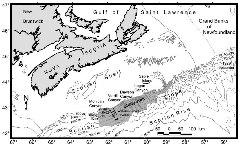
The first image (below) is a map showing the study area and some regional context. The Scotian continental slope is offshore Nova Scotia, Canada.
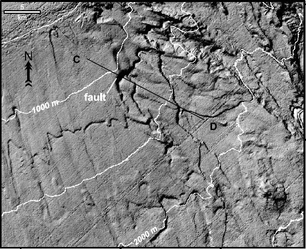
The image below is a multibeam sonar image of the sea floor (scale in upper left corner). Note the continuous escarpments cutting across the slope…roughly parallel to the bathymetric contours.
The image below is a seismic-reflection profile along line C-D denoted in map above. This type of normal faulting on steep submarine slopes is quite common. In some cases, complete and abrupt failure can create mass flows … in other cases, slower creep and/or faulting occurs.
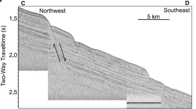
The Scotian Slope received abundant sediment during the Last Glacial Maximum, when sea level was out at the present shelf edge, and during post-glacial transgression from very active glacial outwash systems.
Check out the Mosher et al. (2004) here (subscription required).
~~~~~~~~~~~~~~~~~~~~~~~~~~~~~~~~~~~~~~~~~~~~~~~~~~~~~~~~~~~~~~~~
Best TV show theme song ever?
I agree with the folks over at Hidden Track … the theme song for the 1970s TV show “Barnery Miller” has always been my favorite.
If you like your theme songs nice and funky, then this has got to be your favorite as well.
Here’s a video someone put together with the song. Take a listen.
Good stuff.
~~~~~~~~~~~~~~~~~~~~~~~~~~~~~~~~~~~~~~~~~~~~~~~~~~~~~~~~~~~~~~~
Friday Field Foto #42: Destroyed Darwin Plaque in the Andes
I have a little different field photograph this week. In honor of Darwin Day the other day, I remembered I had this photograph I took a few years ago while on a field trip in the Andes near Mendoza, Argentina.
Mendoza, Argentina and Santiago, Chile are connected by Portillo Pass through Cordillera de los Andes. Charles Darwin used some time on land during his journey in 1835 to explore this pass. On the other side of the divide, on the Argentine side, he discovered a grove of petrified trees while exploring the geology of the region (I didn’t have time to look up the details of the fossils…if you know more, share it below).
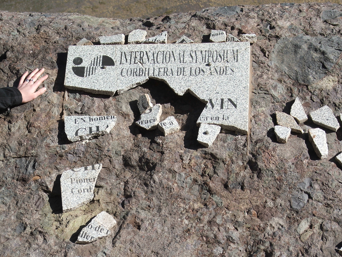
In 1959 a plaque along the road on the Argentine side of the divide was erected to commemorate the discovery.
Why is the plaque broken? According to our field trip leaders, religious extremists are responsible…presumably because they don’t appreciate Darwin’s work or the fact that he is being remembered.
…sigh…
~~~~~~~~~~~~~~~~~~~~~~~~~~~~~~~~~~~~~~~~~~~~~~~~~~~~~~~~~~~~~~~~~~~~~~~~~~~
A couple new geology-related blogs
As always … at least they are “new” to me.
I found a great, fairly new blog called The Dynamic Earth. And the best part is that so far it looks to be a sedimentary-rich blog. Sounds good to me. He’s got a sweet photo of some hummocky cross-stratification for the header image (Cretaceous of Utah?). Check it out.
Have you seen the blog for Earth Learning Idea? They are posting an Earth-related activity every week for the The International Year of Planet Earth (IYPE). They are designed to be cheap and relatively easy to set up.
I really enjoy watching my Geoscience Blogs list on the sidebar grow.
UPDATE: Also check out Ten Million Years of Solitude … so new there’s only two posts (as of 2/15/08).
UPDATE #2: One more thing … when can we get a new blog not using Blogger? You can get a blog hosted for free at WordPress.com (similar to blogspot). The software is better, in my opinion … just sayin’ :)
~~~~~~~~~~~~~~~~~~~~~~~~~~~~~~~~~~~~~~~~~~~~~~~~~~~~~~~~~~~~~~~
Coffee drinker quiz fun
Good ol’ internet quiz fun … it’s super fast.
I love coffee. Sometimes I think about not drinking it…because it would be healthier or something like that. No way, I love it.
~~~~~~~~~~~~~~~~~~~~~~~~~~~~~~~~~~~~~~~~~~~~~~~~~~~~~~~~~~~~~~
Sea-Floor Sunday #11: Continental slope, Makasser Strait, Indonesia
The sea-floor image this week is one of my favorites that I’ve seen in the published literature. It is from a paper by Saller et al. (2004) called Linked lowstand delta to basin-floor deposition, offshore Indonesia (find out more here). The Makasser Strait is between Kalimantan and Sulawesi in Indonesia. For some regional context, see this map.
You definitely should click on this to see the full-res version.

To orient you a bit … this is a perspective image looking west at the continental slope. The continental shelf edge of Kalimantan is near the top of the image and the base of the continental slope (~2000 m water depth) is at the bottom of the image. The image itself is a coherency map superimposed on the 3D bathymetry. In this image, the dark areas of the coherency attribute represent steep slopes or chaotic signal. When it is put together and then draped over the bathymetry, this image is similar to a shaded relief map.
What you should take away from looking at this image is how complex the continental slope bathymetry is. Gullies, channels, canyons, mass-wasting scars, and other features dominate the slope. This area is very near the Mahakam River delta and thus a supply-dominated slope. That is, there is a great abundance of clastic detritus delivered to the ocean during the last couple million years (at least) — the continental slope is trying to build out into the ocean basin.
Here are a couple images zoomed-in.

This image (above) is the uppermost slope — the current shelf edge is just off the top of the image. Note the multiple and deep canyons cutting through the upper slope. Sediment waves form as turbidity currents spill out of the canyons. That is, the height of the sediment-laden current is taller than the canyon is deep. We don’t quite understand the formation of sediment waves in great detail, but better imaging and monitoring are helping. I’ll put together a post about the “state of the art” regarding sediment waves another time.
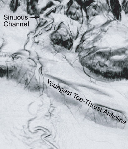
The next zoomed-in image (above) is a bit further down the slope. Here, the deep canyons are transitioning to channels. Note the sinuosity of the channel. Another common feature of supply-dominated margins like this are structural features related to large-scale gravity-induced movement. In this case, the toe-thrust anticline represents relatively slow failure of the entire slope — imagine the slope slowly falling towards the deep — you end up with extensional features on the upper slope and compressional features at the base of the slope. Note the margin-parallel trend (roughly) of the strike of the anticlinal features. It gets a bit more complicated since these are long-lived features that grow over time (i.e., they are not the product of a single “event”). What’s cool is that these structures can act as a “backstop” for sedimentation such that “mini-basins” are formed behind them. The mini-basin will eventually fill and then the subsequent gravity flows will find their way to the next lowest spot. This is generally analogous to the mini-basin physiography of the Gulf of Mexico that I showed in this post. Those structures, however, are created by salt movement.
The Saller et al. (2004) paper goes into a lot more detail regarding both the features on the modern sea floor as well as the evolution of the shallow subsurface and history of sedimentation on the margin during the Pleistocene sea-level cycles.
~
See all Sea-Floor Sunday posts here.
~~~~~~~~~~~~~~~~~~~~~~~~~~~~~~~~~~~~~~~~~~~~~~~~~~~~~~~~~~~~~~
Friday Field Foto #41: Armored mudball (eroded out)
Realizing how fun posting a geopuzzle can be, this week I asked the readers to tell me what they think the photo is all about. I got some great responses fairly quickly. See answer and analysis below.
Click on photo for a bigger version.

It is from the Eocene Grès d’Annot Formation of southeastern France.
Unfortunately, I don’t have any fun prizes to give away…maybe I should get some ClasticDetritus.com t-shirts made. For now, if you win you get to brag to your friends!
Happy Friday!
~
ANSWER:
Essentially, Gary gets it right with the first comment.
First things first … this is a cross-sectional view of part of thick (~1.5 m) turbidite bed. The thing that used to be there was an armored mudball (is that one of the best terms or what?).
Here’s the deal: mud/clay “clumps” are commonly ripped up from the sea floor as sand-laden turbidity currents come by. Since the mud is more cohesive, they can remain in clumps as they are being transported. Think about trying to make a mudball with your hands compared to making a sandball … the sandball will fall apart. Then, the mudball probably saltated on the sandy substrate (or grains in suspension just stuck to it?) picking up the grains as it went. Now, think about rolling a log of cheese in some chopped nuts … they’re gonna stick to the cheese (mmm…cheese log). The mudball becomes “armored” with very coarse to granule-sized grains just as the cheese log becomes armored with pecans. The armored mudball is deposited when the high-density turbidity current transporting it loses its momentum for one reason or another and drops its sediment load. The sediment becomes sedimentary rock, the area is uplifted and exposed to the surface and, finally, the mudstone preferentially erodes out of the sandstone leaving only the armor behind.
Callan gets the process kind of right … replace the jellyfish with mud, and replace the windstorm with a submarine turbidity current. :)
Andrew…had this been a bedding plane as you postulated, and not a cross section…I would’ve guessed exactly what you did as well. You can imagine the coarser material collecting in the pit similar to what’s seen in modern stream lag deposits.
Mathias brings up some interesting details regarding the composition of the material. Honestly, when I was there taking this shot I didn’t look at the grains very closely. So, unfortunately, I can’t answer you precisely. But, it does look like a bunch of quartz and feldspathic grains with perhaps some meta-sedimentary grains (dark ones near top?). As for slightly larger grains in the bottom…my guess is they simply fell from the top and have collected in there as the pit eroded bit by bit (remember, this is a vertical cross-sectional view).
Yet another interesting detail alluded to by both Mathias and Andrew is why such a large clast (pebble to cobble) is “floating” in a sand matrix. There are a couple of ways to do this. First, depending on the state of lithification of the mudball when it was ripped up and suspended in the turbidity current, it is could’ve been quite a bit lighter. That is, hydrodynamically it behaved similar to the medium-grained sand. We see this all over the place with unarmored mud clasts (or, mudstone rip-up clasts)…they’ll be “floating” within a matrix of sand. In this case, however, the armor may have precluded such a process. Another option is that the armored mudball simply rolled along the sandy substrate. Think of large pebbles/small cobbles on a beach…they are large enough that they can be rolled along the sand surface by the waves. This bimodality in grain size is seen quite often (e.g., pebbly sandstones). One thing not evident in the photo is that the grain size of the armor is present in the very lower part of this turbidite bed (~40 cm below bottom edge of photo) and in other beds stratigraphically below and above.
I’m not sure of the exact answer for this particular example … we could go to the French Alps and check it out? Any takers?
If you want to read a bit more about armored mudballs, this page talks about them a bit more (and I found this very short reference to the largest known armored mudball from 1982 Mt. St. Helens mudflows).
~~~~~~~~~~~~~~~~~~~~~~~~~~~~~~~~~~~~~~~~~~~~~~~~~~~~~~~~~~~~~~
Search terms that lead to this blog
Every once in a while it is fun to look at the search terms that lead people to your blog. I even think this went around as a meme some months ago.
Here’s what I got the last couple of days:

These are the terms as shown by the basic stats on blogs using WordPress.com.
I especially like “3d volcano cakes”.
~~~~~~~~~~~~~~~~~~~~~~~~~~~~~~~~~~~~~~~~~~~~~~~~~~~~~~~~~~~~~~~
