Friday Field Foto #93: Permian debris flow deposit in Death Valley
This week’s Friday Field Foto is from the Death Valley region in California and shows a very nice debris flow deposit (note the hand in the lower right of photo for scale).

Permian debris flow deposit, near Death Valley, California (© 2009 clasticdetritus.com)
This is from the Permian section in a location called Darwin Canyon (I forgot the name of the formation).
This particular deposit at this location was nearly 10 meter thick and sandwiched in between turbidite successions many tens of meters thick stratigraphically above and below. This example exhibits some of the key criteria for recognizing a debris flow deposit:
- muddy matrix (in these rocks it has weathered to that light brownish color)
- clasts of variable size and shape “floating” in the matrix (i.e., matrix-supported conglomerate)
- lack of internal organization (i.e., no discernible trends like normal grading, for example)
- lack of sedimentary structures that indicate traction sedimentation (e.g., cross-bedding)
Happy Friday!
Word clouds for two upcoming conference presentations
As I mentioned last week (as have others as well) it is abstract-writing and presentation-preparation season. Thankfully, the deadline for abstracts for the April 2010 AAPG conference in New Orleans has been extended a couple of weeks.
I’m presenting a talk at the GSA meeting in Portland next month about some work I did for my Ph.D. looking at the tectonic influence of sedimentation in the Magallanes Basin in southern Chile. A paper for this work is now in press for Basin Research and should be out early 2010. This talk is in in this session on Tuesday afternoon. Here is the wordle.net word cloud for that abstract:

I was also invited to present at the AGU meeting in December (which is in San Francisco as always). This is going to be a very cool session focused on discussing how external (allogenic) factors and internal factors (autogenic) interact to produce the sedimentary record. Some work I did looking at a Holocene deep-marine record compared with paleoclimate records is out in GSA Bulletin this month (I hope to finish a blog post about it very soon). The program is not finalized yet, so check back for details of when the session is. Here is the wordle.net word cloud for that abstract:

I’m looking forward to sharing this work with others and checking out what others are doing!
Sea-Floor Sunday #55: MBARI’s Benthic Rover

credit: mbari.org
This week’s Sea-Floor Sunday is a link to a recent post on Wired Science blog (which is a fantastic site, by the way) about Monterey Bay Aquarium Research Institute’s (MBARI) Benthic Rover.
What is cool about the Benthic Rover is that it is designed for long-term deployments — it just finished a month-long mission and will be doing longer and longer missions in the future.
The term ‘benthic’ refers to the ecological zone near and on the sea floor. Geologists commonly refer to the distinction of benthic foraminifera and planktonic foraminifera in the rock record — the former representing micro-critters that lived on the sea floor and the latter at or near the sea surface.
What does the Benthic Rover do?
About the size of a compact car, the new robot carries equipment to measure the amount of oxygen being consumed by organisms on the ocean floor, as well as the amount of food that filters down from surface waters. For the first time, scientists will be able to track how changes on the surface of the ocean affect marine communities down below.
This is super cool — and the fact that it will be doing longer deployments in the future means it can collect data continuously for weeks or even months in a row.
The Wired post has a great video of the rover in action on the sea floor — check it out.
Also check out this press release about the rover from MBARI’s website.
On this day eight years ago …
… I was in the mountains of west Texas helping run a geology field trip with my master’s degree adviser.

Delaware Mountains, west Texas (© 2009 clasticdetritus.com)
We were driving down a lonely road in a caravan of five vehicles from the ranch house where we were staying to the first field stop of the day. We had two-way radios in each vehicle so we could give directions and point out geologic features on our way to the field. One of the field trip participants came on the walkie-talkie and said “Hey, you guys might want to turn on your radio … apparently a small plane crashed into one of the twin towers in New York.”
I remember thinking “Whoa, that’s crazy … how does a pilot not see the twin towers?” About five minutes later the NPR announcer confirmed that it wasn’t a small plane — it was a commercial airliner. The radio announcers were trying to collect information from reporters to determine what had happened. I remember sitting shotgun and my adviser driving — we just looked at each other very confused. A few minutes later the second tower was hit. This information came through the radio in real time … as it happened. I will never forget the next 10-20 seconds as my brain went into overdrive attempting to figure this out. Looking back now, this seems like a long time to realize what was transpiring.
The following 2-3 hours aren’t as crisp in my memory — we finally got to our destination, where we would start hiking, but simply stood around the vehicles listening to the radio broadcast. We had a few satellite phones and people, including myself, were trying to reach family and friends.
We decided as a group to head out to the outcrops … at least for a little while. It was a good choice, I remember being thankful for the walk and how it cleared my head a little bit. But here I was, hiking in a remote and beautiful desert — while my country was under attack — it was surreal. We spent a bit of time looking at the rocks but then headed back to the vehicles and made it back to the ranch house by mid-afternoon. The caretakers were kind enough to move their TV into the common room and we all watched — seeing the visuals for the first time after only hearing it on the radio all day.
Because all commercial flying was grounded and everyone on the trip had traveled here by plane we decided to go on with the field trip. Almost all of the participants were from Houston and a group of them decided after a couple more days that they’d rather spend a day driving across Texas and get home than wait to hear about when we could fly. My adviser and I ended up flying back to Colorado when we were scheduled to … the following weekend.
I don’t know why I felt like sharing this story this year — I guess it’s just one of those events where people remember the details of exactly what they were doing and exactly how they felt.
Abstracts are like sculptures … and sometimes trees
The last month or so has been abstract-writing season. For me, there are three upcoming conferences in the U.S. that include sessions appropriate for my interests and expertise — GSA, AGU, and AAPG.
GSA is appropriate for my tectonic interests — I will be presenting the results of this work, which is now in press. AGU can be hit or miss for me, but this year there is a fantastic session about external vs. internal forcings on stratigraphic patterns that I was invited to present at (plus it’s local for me, which makes it a no-brainer). AAPG is inherently more applied as a whole, but the meeting usually includes at least a few sessions that delve into basic sedimentary research so it is definitely worth attending.
The deadlines for abstracts for these three meetings are all within a month of each other — the last one, AAPG, is due next week — so I’ve been fairly busy writing my own and reviewing those on which I’m a coauthor.
My strategy for writing conference abstracts has changed over the years. I used to be more concerned with getting the wording exactly right from the start. These days, I tend to go for the ‘brain dump’ method — I just start writing thoughts in a more prose-like way. It is certainly a giant mess at first. Sometimes I still find myself bogged down on details and wordsmithing at this stage, but I try to snap myself out of that. Instead of the blank canvas analogy, I think of it as putting all the clay into a pile before making a sculpture (note: I have no actual experience sculpting, so I could be way off with this analogy). You gotta have something to work with first! You need a lump of ‘stuff’ that can be thrown around and shaped into a general form. And you don’t want to spend time working on nuanced finishing touches at this stage … who knows, the entire thing might need to be reformed. As the form takes shape and looks like something recognizable, the rough edges can be smoothed out and, hopefully, a worthwhile product is created.
For abstracts on which I’m a coauthor I think of them as trees that need some pruning. If it’s in a good shape, just a bit of small-scale pruning around the edges — you know, to make it look a little prettier. If the abstract needs more work, I might modify more significantly — in some cases, I’ll bring out the chainsaw and get rid of substantial limbs. Very rarely do I need to chop the tree down and plant a new one.
International Vulture Awareness Day — Andean Condors
 One of the great things about the blogosphere is that it alerts you to an event that may have slipped under your radar — yesterday (Sept 5) was International Vulture Awareness Day. Many others in the geoblogosphere have already posted (Geotripper, Looking for Detachment, The Ethical Paleontologist, and Geogypsy)
So, a day late, here is my post about Andean condors (which is actually repost from a while back).
The Andean condor is huge … wingspan can reach 3 m (10 ft). On average, this is longer than its North American cousin, the California condor (although they are longer from beak to tail).
Because Andean condors like to take advantage of rising warm air to soar, you typically find them along mountainsides and big vertical cliff faces. As it turns out, this is also where you can find geologists … that’s where the rocks are.
The photo below zooms in on one while it is flying … although it is difficult to get a sense of scale of the bird against the blue sky.
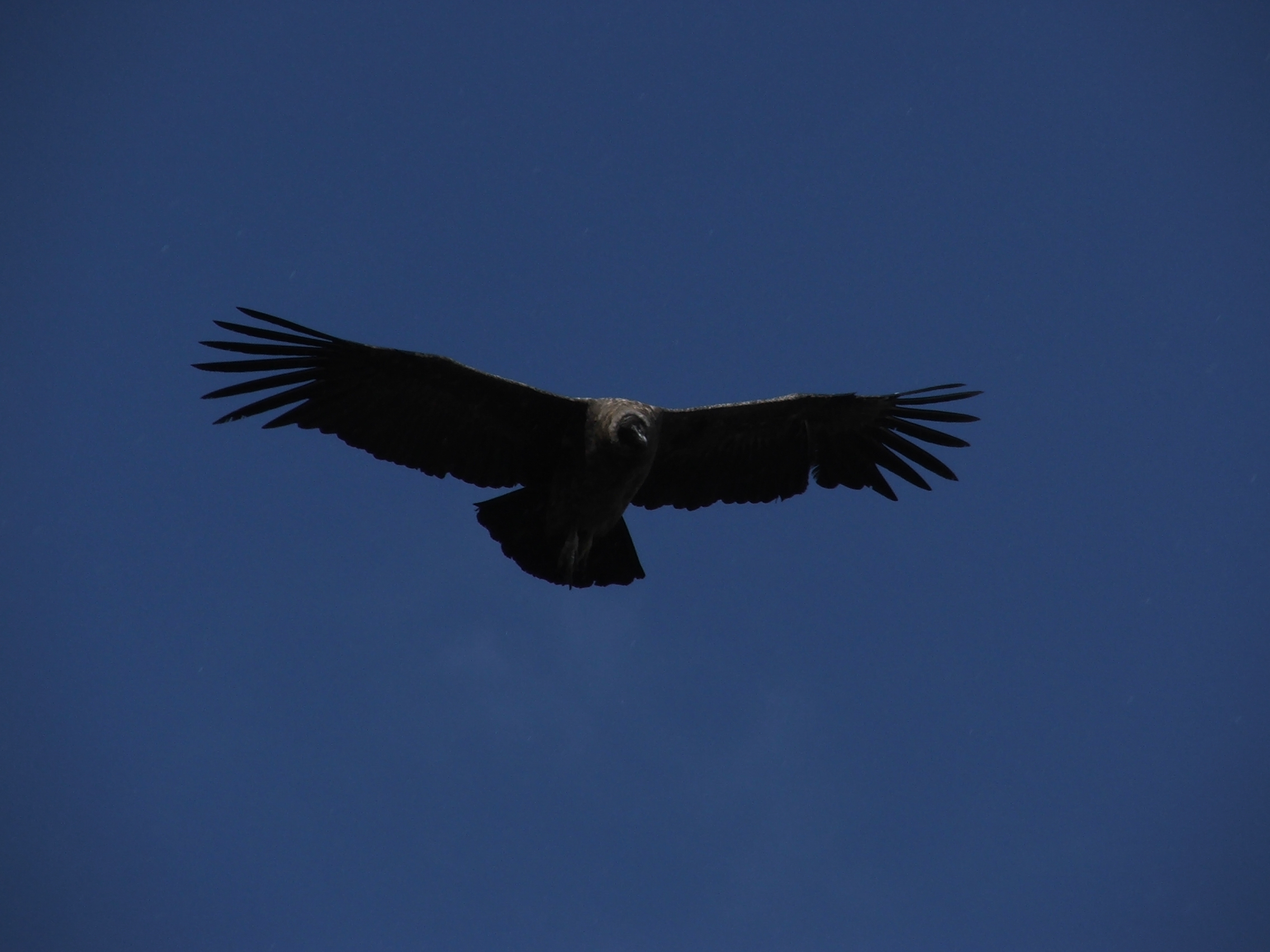
Andean condor, The Sierra Contreras, Chile (© 2009 clasticdetritus.com)
The next photo below was taken a little bit later that same day. Condors are scavengers, part of the vulture family, and often circle around you (presumably waiting for something bad to happen to you). Once one or two start circling, many more show up. It may be a bit tough to see in this photo, but there are about 10 or so in this shot. We ended up counting 25 at one point!
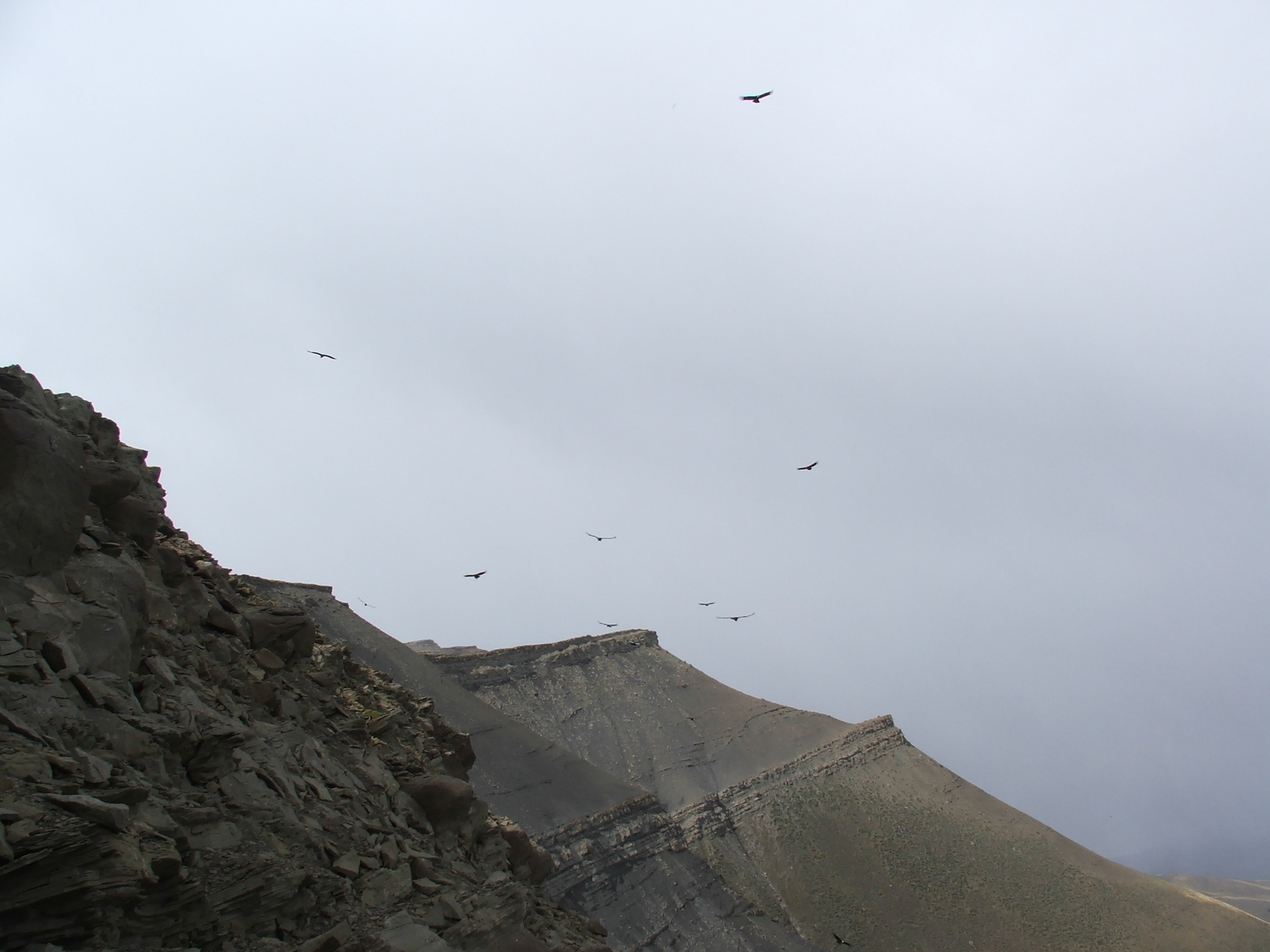
Andean condor, The Sierra Contreras, Chile (© 2009 clasticdetritus.com)
Even though they are scavengers, they will sometimes fly only a few meters above your head checking you out … it’s a bit disconcerting when your precariously perched on a cliff trying to collect some data.
Finally, the photo below is the best close-up I have of a Andean condor not flying. Note the nice white ‘collar’, very preppy … also, note the Cretaceous conglomerate on which it is perched.
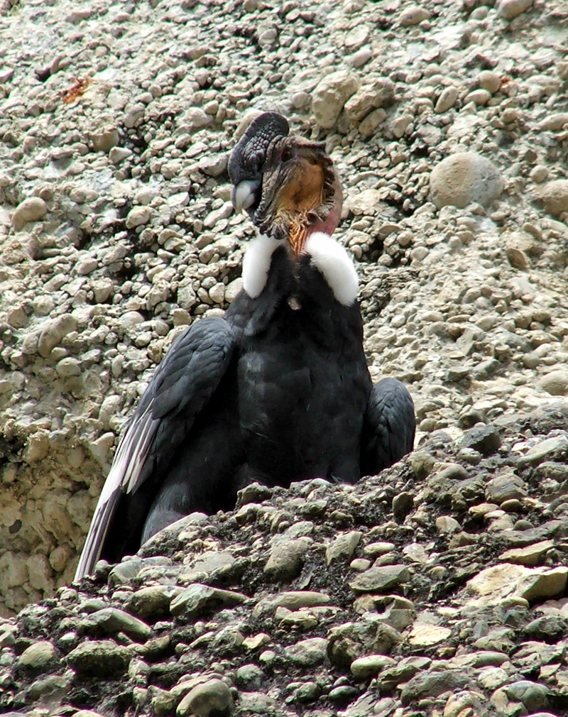
Andean condor, Cerro Benitez, Chile (© 2009 clasticdetritus.com)
Sea-Floor Sunday #54: Bathymetry of the Adriatic Sea
This week’s Sea-Floor Sunday image is a perspective image of the Adriatic Sea. The warm colors are shallower waters and the cool colors are deeper; it’s also highly vertically exaggerated to emphasize the changes in water depth.

Bathymetry of the Adriatic Sea (credit: http://engineering.dartmouth.edu/adriatic/index.html)
I found this image on this site from Dartmouth that summarizes physical oceanography research. They are looking at the dynamics of various currents in the sea — having a good map of the sea floor is key for understanding these currents.
Friday Field Foto #92: Miocene sedimentary rocks, Tierra del Fuego
This week’s Friday Field Foto is from some Miocene sedimentary rocks exposed along the Atlantic coast of Tierra del Fuego.
The bottom part, from base of visible section to just above the top of the hammer handle, is alternating siltstone and fine-grained sandstone — most of it plane-laminated with some ripple-laminated beds. Above the hammer is alternating granule-pebble conglomerate beds (brown) and fine- to medium-grained sandstone (beige). The conglomerate beds are normally graded with some faint horizontal stratification. The sandstone beds are also normally graded with plane-lamination near base.

Miocene sedimentary rocks, Tierra del Fuego (© 2009 clasticdetritus.com)
Load structures, flame structures, and other soft-sediment deformation features are abundant, especially along bedding planes.
The light gray features sticking out of outcrop are silty concretions — they are a bit more indurated and thus more resistant to erosion.
What environment do these rocks represent? Essentially, this succession is a mix of traction (i.e., bed load) and suspension fall-out sedimentary structures. So, it’s an environment where at least silt and sand (and possibly granules) are transported in suspension. The general interpretation for these rocks is that they are in a delta-front area. I think that is a pretty good interpretation — river mouths/delta fronts can be extremely active areas with high sediment flux. When I was there looking at these, the coarse-grainedness made me think of a submarine fan delta — maybe something like this.
But, I was only there for a day … need more data … who wants to go?!
Happy Friday!
Friday Field Foto #91: Snow-covered outcrops in the distance
In my head it seems like a lot of my Friday Field Fotos are from my PhD field area in Patagonia, but I was looking through the list and realized I haven’t shown one of the actual outcrops in about a year.
Today’s photo is a bit dark, but it was a dark day … it was taken looking to the north while standing on top of this outcrop. The snow-covered mountain in the distance is called Cerro Divisadero and was my field site for some detailed work, which became this paper. There are no roads to get to that mountain — read about how to get there on this post.

Tres Pasos Formation, northern Magallanes Basin, Chile (© 2009 clasticdetritus.com)
The outcrop from which this photo is taken is generally the same stratigraphic level. Note how the strata are dipping to the right in the river valley and on mountainsides. Basically, you are looking along strike.
Cerro Divisadero is infamous for the bad weather — even when other areas further south are quite nice. For example, on this particular day the mountain on which this photo was taken was free of snow even though they are similar elevations. The Patagonian ice sheet is off to the west (left in this photo) about 30 km away and it always seemed the winds simply picked up a bunch of snow and then dumped it on that mountain.
Happy Friday!
Sea-Floor Sunday #53: Deep-sea erosional scours
This week’s Sea-Floor Sunday image is from last week’s issue of AGU’s EOS newsletter. I’m always thrilled to open up my copy of EOS and see articles related to the exploration and mapping our ocean floor.
Using state-of-the-art technology, researchers from the National Oceanography Centre in Southampton, UK have mapped erosional scours offshore northwest Africa. These erosional features are created by powerful sediment-laden gravity flows, called turbidity currents.

credit: AGU EOS, v. 90, no. 32; http://www.agu.org/pubs/eos/eo0932.shtml
These features are not small … check out the scale on the map. Individual scours are hundreds of meters across, kilometers in length, and >10 meters deep. This particular field of scours is located at the mouth of the Agadir submarine canyon.
The more we map the ocean floors the more interesting, and sometimes unexpected, features we discover. The advent of meter-scale resolution multibeam mapping technology is leading to the rise of a ‘new’ discipline — submarine geomorphology. Think about how much we’ve learned about the surface of the Earth on land from high-resolution aerial photos and DEMs. A tiny fraction of the sea floor has been mapped at this resolution — we are essentially at the beginning of a new age of exploration and discovery. It’s a very exciting time.
