I was looking at the always-awesome Earth Observatory website from NASA and came across an interesting comparison of images of a river delta over time.
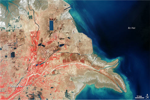
The first image below is the Huange He delta in 2000.
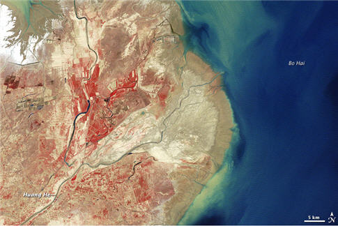
The comparison image below is from 1979.
Here’s the blurb from the EarthObservatory site:
Compared to the earlier image, the 2000 shot shows an increase in developed land and a slight decrease in vegetation. The most striking difference between the two images, however, is the shape of the coastline. A steady supply of sediment expanded the Yellow River delta until it pushed into Bo Hai like a giant hook. Sediment colored the coastal waters bright blue. This delta-building process has added several hundred square kilometers of land to China’s coast.
I wonder if the change from a “smoother” coastline to the more “birdsfoot” river-dominated morphology has mostly to do with the land use changes? That is, a more restricted river course would preclude frequent avulsions and construction of the distributive dispersal pattern. A more restricted river course would result in more spatially focused growth. I don’t know … just thinking out loud.
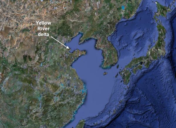
In case you are wondering where this delta is along the China coast, here is a regional GoogleEarth image.
–
There’s a similar comparison from the same time periods of aquaculture development along the shores of Bo Hai Bay
~~~~~~~~~~~~~~~~~~~~~~~~~~~~~~~~~~~~~~~~~~~~~~~~~~
Photos of fieldwork in Patagonia
I am back in the States and very slowly reconnecting myself to the internet. The contrast from little to no connectivity while traveling and doing field work to full connectivity back at home is a bit overwhelming . It may take me a week or so to get back into the swing of things.
To get things started, here are some photos from this recent trip. I’ve chosen photos that I think nicely portray what it is like to hike around some of these mountains.
The main goal of the field work that me and a colleague did for the five days following our conference was to put some detailed work into a regional context. So instead of measuring a lot of section and doing very detailed stratigraphic characterization, we spent our time looking at some rocks we had not visited before to test some ideas about regional correlation. The rocks weren’t spectacularly exposed but good enough address our concerns about the stratigraphy of the basin at the scale of 10s of km.
First, here is our trusty camioneta (pick-up truck) on a gravel road.

The road to Chingue (© 2009 clasticdetritus.com)
For two days we hiked up a pretty big hill to see the rocks exposed at the top, which gave us a spectacular view of the landscape.

Rio de las Chinas from Cerro Cazador (© 2009 clasticdetritus.com)
What never comes through in these photos is the Patagonian wind … I nearly fell over trying to take this photo (and many others that day).

Looking north to Sierra Dorotea (© 2009 clasticdetritus.com)
On the very top of one of the mountains we hiked up.

On top of Cerro Cazador (© 2009 clasticdetritus.com)
The week had very typical Patagonia weather … partly cloudy and extremely windy. One of the good things about the wind is that it makes it difficult for any precipitation to set up — the clouds are blown away too quickly. When the wind stops, the clouds build up and it can get nasty. Luckily, this didn’t happen to us last week.

Looking south to Cerro Sol (© 2009 clasticdetritus.com)
I obviously show a lot of photos of exposed rock on this blog but we spend a lot of time hiking across the grass-covered hills just to get to the rocks.

Cerro Cazador (© 2009 clasticdetritus.com)
The Rio de las Chinas is a beautiful meandering river that one can only see if they spend the time hiking up the adjacent hills. This view is to the west with the Patagonian Andes proper off in the distance.

Rio de las Chinas from Cerro Cazador (© 2009 clasticdetritus.com)
The typical inhabitants of the area.

Sheep on Cerro Cazador (© 2009 clasticdetritus.com)
Finally … our standard lunch in the field: salami and mustard on semi-stale bread … yum! That reminds me, I need to clean my knife now. Last time I forgot and found some salami fat still embedded in it when I opened the blade months later.

Lunch in the field (© 2009 clasticdetritus.com)
I did not take any photos during the conference — was WAY too busy. This was the first time I have run a conference that included days in the field. It was a lot of work making sure all the logistics were always lined up correctly each day. In the field, I was either leading the group to the outcrop, but more often I let my co-convenors lead the group while I was the “sweeper” in the back of the pack. At some points I felt like a sheep dog rounding up the strays. More about the conference in later posts.
–
Note: Zoltan attended the conference — check out a few of his photos (including a gigapan!).
~~~~~~~~~~~~~~~~~~~~~~~~~~~~~~~~~~~~~~~~~~~~~~~~~~
Conference is over, time to relax
Right now I am in southern Chile sitting in a hotel lobby decompressing after running a week-long field conference. Man am I exhausted. I along with two colleagues have been planning for this thing for over a year … I can’t believe it’s over. I am very excited to not have to plan anymore!
It was a success — nearly everybody went out of their way to tell us they got a lot out of it. Nobody got hurt and there were only a few very minor glitches behind the scenes.
It was a pretty small conference (~30 attendees) focused on deep-marine sedimentary deposits. I went to a field conference last year that had 3 days of talks and then 2 days of field trips. It felt a bit disconnected to me — so we decided to have talks in the morning and then go out in the field in the afternoon. It was a bit of an experiment but I think it worked. We organized it such that the talks in the morning were generally within the theme of the rocks we looked at in the afternoon. For example, on the day we were to look at possible submarine channel levee deposits, we had a few talks from attendees about similar deposits from around the world.
I’ll be down here for another 5 days to do a bit of field work with my co-worker and our colleague and his students who are starting field projects down here. I’m looking forward to not being the pied piper leading 30 people across a mountainside and worrying about people turning an ankle or something … oh yeah, and explaining the geology clearly as well. The next 5 days I can relax and get my head into collecting some data.
Looks like I’ve missed a lot in the geoblogosphere … maybe I’ll have a chance to catch up soon.
~~~~~~~~~~~~~~~~~~~~~~~~~~~~~~~~~~~~~~~~~~~~~~~~~~
Papers I’m Reading – February 2009
I haven’t done a papers-I’m-reading post since November of last year. Not because I haven’t been reading papers … mostly because I’ve simply forgotten to post about it.
–
Here’s the list for February:
~~~~~~~~~~~~~~~~~~~~~~~~~~~~~~~~~~~~~~~~~~~~~~~~~~
Sea-Floor Sunday #41: Bathymetric map of Mediterranean Sea
Although the release of the ‘Ocean’ feature in newest GoogleEarth was last week, I still have a few other draft posts with great bathymetric images I wanted to get out. Plus, I haven’ t had the time to really explore the GoogleEarth sea-floor features. I will certainly be including those images in this series in the coming months so stay tuned.
–
This week’s Sea-Floor Sunday is a really nice synthesis map of bathymetry of the Mediterranean Sea. Click on the map below or here to go to the page where you can see more.
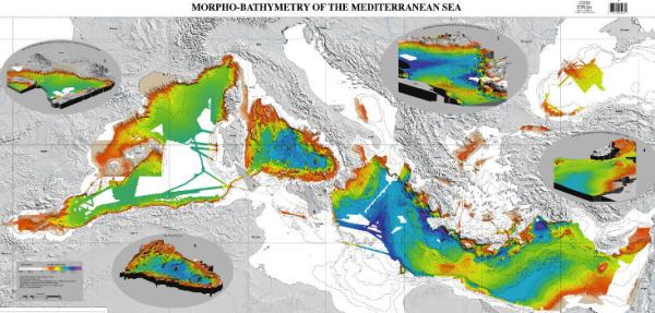
credit: Loubrieu B., J. Mascle & MediMap Group (N. Chamot-Rooke), 2007. Morpho-Bathymetry of the Mediterranean Sea, CIESM and Ifremer Special Publications (http://www.ciesm.org/marine/morphomap.htm)
This is a nice resource if you are interested in the complex plate tectonics of the Mediterranean area. The map also includes a few nice perspective images as well.
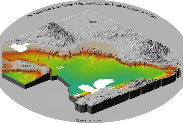
Perspective image of northwestern Mediterranea Sea (credit: http://www.ciesm.org/marine/morphomap.htm)
Look at all those submarine canyons cutting across the shelf edge … very cool.
~~~~~~~~~~~~~~~~~~~~~~~~~~~~~~~~~~~~~~~~~~~~~~~~~~
Friday Field Foto #77: Liesegang banding in cross-bedded sandstone
This week’s Friday Field Foto is from the Valley of Fire area in southern Nevada. In 2004 I went on a trip with several other graduate students to this and surrounding areas.
The photo below shows the chemical/diagenetic banding knowns as Liesegang bands.
The rocks above are (if I remember correctly) within Jurassic eolian units, which are great rocks for seeing some of the most beautiful expressions of the Liesegang phenomenon. In some cases, the banding will follow primary stratification, in other cases, it will cross-cut it.
See Hindered Settling’s post about Liesegang features.
Happy Friday!!
~~~~~~~~~~~~~~~~~~~~~~~~~~~~~~~~~~~~~~~~~~~~~~~~~~
I need to get out of the office
In 10 days I leave for a three-week trip to Patagonia. I can’t wait.
I haven’t spent multiple consecutive days in the field since last April, which is way too long! I’ve been looking at “digital rocks” since then and need to see some actual rocks in their natural habitat. There’s also something nice about the field in that you only have to worry about the basics … eating, sleeping, not falling off a cliff, not getting eaten by a puma, and — oh yeah — correctly interpreting Earth history.
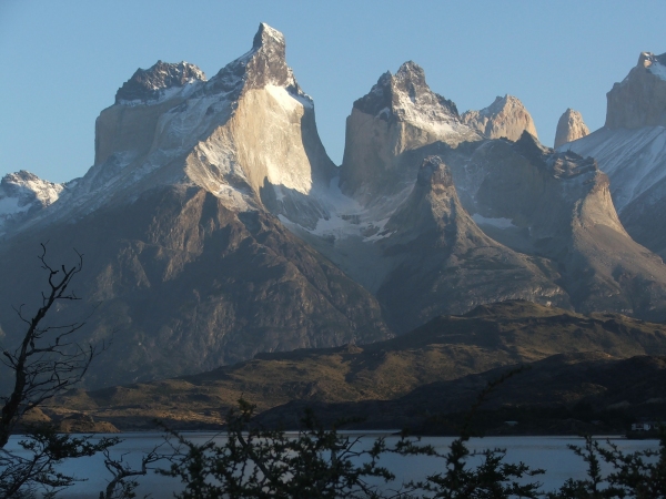
I just need to get through the next week and a half … and then I’ll be here:
~~~~~~~~~~~~~~~~~~~~~~~~~~~~~~~~~~~~~~~~~~~~~~~~~~
The Accretionary Wedge #15: Pondering the geological future of Earth
Unfortunately there were not many submissions to this months Accretionary Wedge geoscience blog carnival. But, what this month’s installment lacks in quantity it makes up for in quality.
–
First, Michael Welland of the blog Through the Sandglass ponders far into the Earth’s future — 100 million years — and, inspired by Zalasiewicz’s book The Earth After Us, discusses what future geologists/anthropologists might infer from a single layer in the stratigraphic record.
Essentially none of our infrastructure, creations, and artifacts will survive 100 million years of erosion, burial, diagenesis, and tectonics in their original compositional and structural form, and we ourselves, inhabiting the erosional land rather than the depositional marine realms are poor fossil candidates – think of the extent (or lack of it) of the record of our ancestors in the African Rift Valleys.
At the end of his post reviewing and discussing Zalasiewicz’s book, Michael poses a question to the reader:
So, here’s the question, given that our appreciation of plate tectonic processes was a long time coming, difficult, and highly controversial even while their work was going on all around us, in a post plate tectonics world, how would we discern that those processes had ever happened? What would be the evidence revealed to and by geologists of the future that plate motions and plate margin dynamics had sculpted the appearance of our planet? Something to think about as we gaze more closely at other planets?
Head on over to join the discussion.
Next, Hypocentre at the blog Hypo-theses looks at just the next few decades and proclaims that global warming will cause large earthquakes to completely disappear by 2035. Don’t believe it? Well, you better go check out his post.
Silver Fox at the blog Looking For Detachment investigates where, how much, what kind, and under what conditions ore deposits might be explored for in the future:
I recommend drilling for gold in 1 to 5 million years in the Mendocino, CA, area, with 2 to 3 million years being my best estimate of the proper timing. For proper and exact placement of drill rigs, I would wait for the future, when faults and fractures controlling future ore deposits will be identifiable, and when rocks will be available for sampling.
That’s just one of several specific predictions.
MJC Rocks at the blog Geotripper doesn’t pick a certain interval of time in the future, but ponders the basic processes and relationships of processes that both cause and are affected by the evolution of the Earth within the context of Black Mesa in northern Arizona:
I have no doubt that a layer will be discovered that represents a mass extinction event wherein a vast number of organisms disappeared forever, including the mammalian megafauna, and perhaps many oceanic species, especially at the top of the food chain, such as many kinds of sharks and whales. Will we be identified as the cause of the catastrophe? Who knows? Someone or something might figure it out. Or maybe not; it might be another of those mysteries that nag and bother the psyches of those who study the earth and it’s past.
Kevin from the blog The GeoChristian discusses some events and processes that will occur over four orders of temporal magnitude (from 1,000 to 1,000,000 years) and ponders them within the context of his own faith.
Finally, is my own post that speculates and discusses a million years worth of deposition.
UPDATE: Chris from Highly Allochthonous addresses the question many of ponder about our magnetic field — when will the polarity reverse? And how long does it take? Read the post to learn more.
–
I thank all those who participated in this month’s Accretionary Wedge … for others, if you didn’t quite finish your submission in time, go ahead and submit it late. I’ll update this post.
~~~~~~~~~~~~~~~~~~~~~~~~~~~~~~~~~~~~~~~~~~~~~~~~~~
