Another GoogleEarth data portal
It seems each week, another online database provides a way to find their information spatially via GoogleEarth. Earlier today, I posted about a new ocean drilling vessel for the IODP (Integrated Ocean Drilling Program). I found myself surfing around their website and found that IODP now offers a GoogleEarth link for a comprehensive map of all boreholes.
Check this out…here are a couple global-scale views of the database.


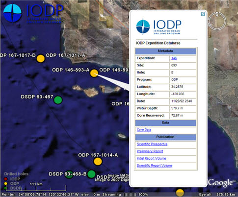
And, similar to other GoogleEarth data portals, when you zoom in and click on a certain location, you get a dialog box that will link you to the online database.
Here’s the link again…and note that this is a .kml file (not a .kmz). Go to “Add > Network Link…” in GoogleEarth and paste the link into the appropriate field.
Awesome! If I didn’t have a dissertation to finish, I would start planning a new research project tonight!!
Does anyone out there know of a website/blog that has a list of geoscience-related GoogleEarth data portals? If one doesn’t exist, we should make one.
~~~~~~~~~~~~~~~~~~~~~~~~~~~~~~~~~~~~~~~~~~~~~~~~~~~~~~~~~~~

Well, this is cool:
http://www.shapes.com.au/GoogleEarthServer/index.html
Kent…yeah, that one is indeed very cool